Cloud top height retrieval method based on satellite tri-linear array CCD (charge coupled device) image

A height inversion and three-line array technology, applied in the field of remote sensing, can solve problems such as the impact of high-precision measurement

Active Publication Date: 2013-09-18
PLA UNIV OF SCI & TECH
View PDF4 Cites 13 Cited by
  • Summary
  • Abstract
  • Description
  • Claims
  • Application Information

AI Technical Summary

Problems solved by technology

However, in the process of detecting cloud top heights using satellite three-line array CCD images, the movement of clouds has a great impact on the measurement accuracy, see appendix figure 1 [Huang Yunxian, Ma Shuo, Bai Heng. Error Analysis of Cloud Top Height Detection by Stereo Observation Method. Journal of Infrared and Millimeter Waves), 2012,31(4):43-48]
At present, there is no report on the specific inversion method for cloud top height detection based on satellite three-line array CCD images. Therefore, it is necessary to find a cloud top height inversion method based on satellite three-line array CCD images

Method used


Image

  • Cloud top height retrieval method based on satellite tri-linear array CCD (charge coupled device) image
  • Cloud top height retrieval method based on satellite tri-linear array CCD (charge coupled device) image
  • Cloud top height retrieval method based on satellite tri-linear array CCD (charge coupled device) image

Examples


Embodiment Construction

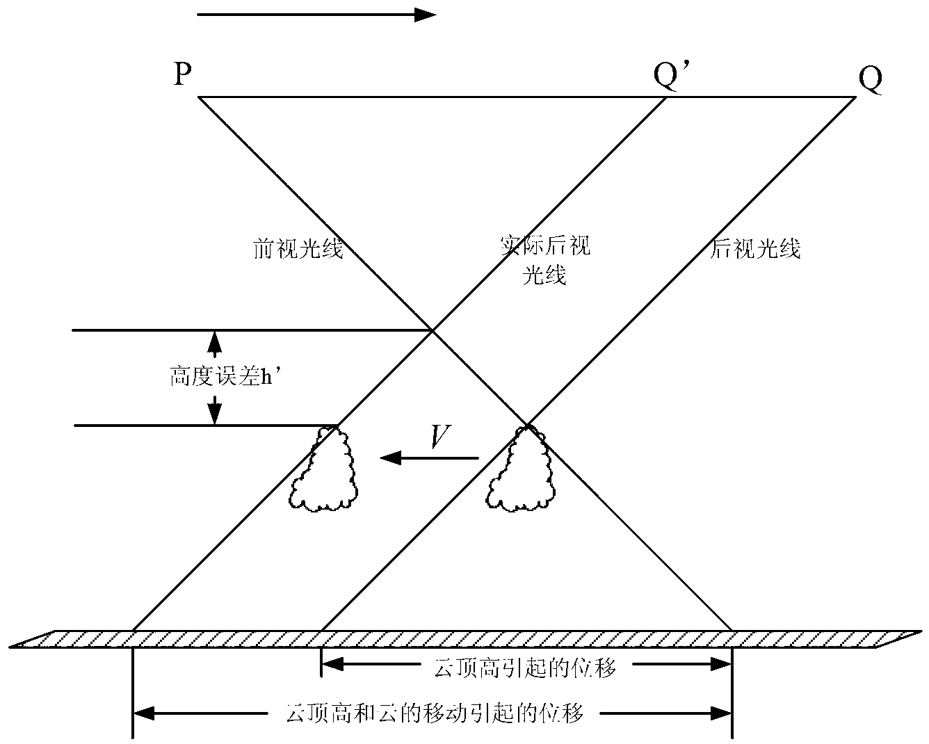
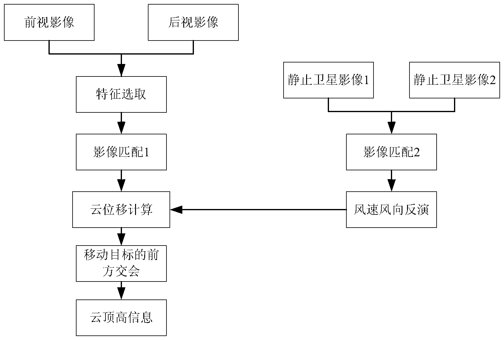
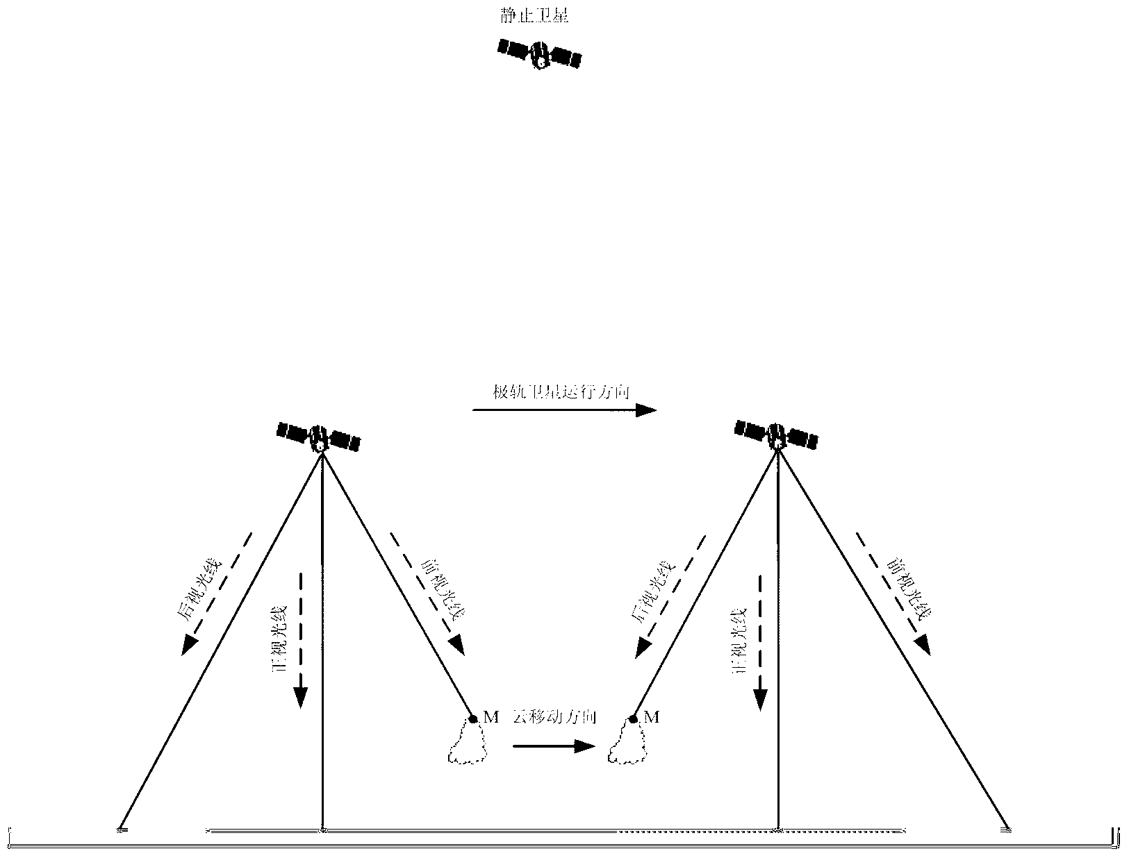
[0027] The cloud top height inversion method based on the satellite three-line array CCD image of the present invention takes the displacement of the cloud into consideration and derives the forward rendezvous formula, through the inversion of the wind speed and wind direction in the same area of ​​the static satellite cloud image, reducing the detection caused by the displacement of the cloud The greater impact of cloud top height. to combine figure 2 , the method is specifically:

[0028] 1. Feature selection

[0029] Select the cloud area for inversion cloud top height in the forward-looking image data.

[0030] 2. Image matching 1

[0031] The present invention uses cross-correlation technology [Leese J A, Novak C S, Clark B B. An Automated Technique for Obtaining Cloud Motion from Geosynchronous Satellite Data Using Cross Correlation. Journal of Applied Meteorology, 1971, 10: 118-132] in the rear view image Find the matching points of the cloud points in the forward-...


PUM


Abstract

The invention discloses a cloud top height retrieval method based on satellite tri-linear array CCD (charge coupled device) image. The method comprises the following steps: firstly selecting a cloud region in a foresight image, carrying out image matching to obtain a corresponding matching point in a back-sight image; secondly, obtaining the continuous static satellite image of adjacent time sections of the foresight image, and retrieving the wind speed and direction in the corresponding region; then, obtaining the time interval of cloud points in the foresight image and the back-sight image, and computing the displacement of the cloud points; and finally inferring the forward interaction formula of a moving target and combining the relative information of cloud point displacement and matching pair to obtain the cloud top height information. In the process of detecting the cloud top height by using the tri-linear array detector, the defects that height detection of the cloud tope height is greatly influenced caused by the moving of the cloud are compensated.

Description

technical field [0001] The invention belongs to the technical field of remote sensing, in particular to a cloud top height inversion method based on a satellite three-line array CCD image. Background technique [0002] Cloud top height information can be obtained through active or passive remote sensing. In active remote sensing, the millimeter-wave cloud measuring radar CloudSat can accurately detect the height of cloud tops, but its detection range is small. In passive remote sensing, cloud top height retrieval methods mainly include approximation method, climatology method, window channel temperature method, multi-channel cloud height measurement, carbon dioxide (CO 2 ) multi-channel method, stereo observation method, etc. When the first five methods invert cloud top heights, indirect measurements such as cloud emissivity and atmospheric temperature and humidity profiles are needed. The errors of these measurements will have a great impact on the inversion accuracy of c...

Claims


Application Information

Patent Timeline
Patent Type & Authority Applications(China)
IPC IPC(8): G01C5/00
Inventor 严卫马烁黄云仙王蕊陆文
Owner PLA UNIV OF SCI & TECH
Why Eureka
Try Eureka