Navigator and navigation method

A navigation method and a technology for a navigator, which are applied in the field of satellite navigation, can solve the problems that the navigator is difficult to distinguish the specific position of the vehicle and the generality of the circuit is not high, and achieves the effect of improving the effectiveness and safety.

Inactive Publication Date: 2013-10-02
周眉 +2
View PDF6 Cites 32 Cited by
  • Summary
  • Abstract
  • Description
  • Claims
  • Application Information

AI Technical Summary

Problems solved by technology

[0005] The technical problem to be solved by the present invention is to provide a navigator and its navigation method, which solves the problem that in the prior art it is difficult for the navigator to distinguish the specific position of the vehicle relative to the overhead, or the problem that the complicate circuit is required and the universality is not high

Method used


Image

  • Navigator and navigation method
  • Navigator and navigation method
  • Navigator and navigation method

Examples


Embodiment Construction

[0022] The specific implementation of the navigator and its navigation method provided by the present invention will be described in detail below in conjunction with the accompanying drawings.

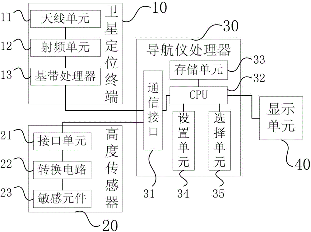
[0023] figure 1 It is a schematic structural diagram of the navigator of the present invention, including a satellite positioning terminal 10 , an altitude sensor 20 , a navigator processor 30 and a display unit 40 . Said navigator of the present invention can be Beidou navigator, GPS navigator and other satellite navigators.

[0024] The satellite positioning terminal 10 receives navigation satellite signals, calculates terminal positioning information and sends it to the navigator processor 30, wherein the terminal positioning information includes longitude, latitude, and height information of the satellite positioning terminal. The satellite positioning terminal 10 includes an antenna unit 11 , a radio frequency unit 12 and a baseband processor 13 connected in sequence, and is conn...


PUM


Abstract

A navigator comprises a satellite positioning terminal, an altitude sensor, a navigator processor and a display unit. The satellite positioning terminal receives navigation satellite signals, calculates out terminal positioning information, and transmits the positioning information to the navigator processor, wherein the terminal positioning information comprises the latitude, altitude and longitude information of the terminal. The altitude sensor senses the altitude change and transmits the terminal altitude value to the navigator processor. The navigator processor, which is used for obtaining terminal position information by the way of matching the terminal positioning information and the terminal altitude value with the pre-stored electronic map information, is respectively connected to the satellite positioning terminal and the altitude sensor. The navigator and the navigation method can realize that a car navigator can automatic judge whether a terminal is driving on an elevated section in a road containing elevated sections, so that the navigator can provide effective route plans and driving advices, through adding a simple altitude sensor and performing corresponding software process.

Description

technical field [0001] The invention relates to the technical field of satellite navigation, in particular to a navigator capable of distinguishing elevated driving and a navigation method thereof. Background technique [0002] With the development of urban traffic and the popularization of vehicles as means of transportation, navigators have become an important auxiliary tool for driving. Viaducts in urban traffic play a significant role in relieving traffic pressure, and are gradually being widely used in large and medium-sized cities. When the vehicle is driving on the elevated section, it is difficult for the ordinary navigator to identify whether the vehicle is driving on the viaduct or under the viaduct, which often leads to route planning errors. This is because of the satellite layout of the satellite navigation system and signal occlusion, etc., which lead to the height and direction positioning of the navigator positioning terminal. The accuracy is poor, and gener...

Claims


Application Information

Patent Timeline
Patent Type & Authority Applications(China)
IPC IPC(8): G01C21/26G01C21/34
Inventor 周眉陈晓挺马陆
Owner 周眉
Why Eureka
Try Eureka