Precise inversion method for soil dielectric constant through global navigation satellite system (GNSS) satellite reflection signal

A technology of reflected signal and dielectric constant, applied in the field of microwave remote sensing, can solve the problem of inaccurate inversion method, and achieve the effect of accurate inversion and accurate soil moisture

Active Publication Date: 2013-10-02
北京卫信杰科技发展有限公司
View PDF8 Cites 12 Cited by
  • Summary
  • Abstract
  • Description
  • Claims
  • Application Information

AI Technical Summary

Problems solved by technology

[0005] The purpose of the present invention is to solve the problem that the actual inversion method is inaccurate when using the GNSS satellite reflection signal to invert the soil dielectric constant in the prior art, and propose a GNSS satellite reflection signal for accurate inversion of the soil dielectric constant. play method

Method used


Image

  • Precise inversion method for soil dielectric constant through global navigation satellite system (GNSS) satellite reflection signal
  • Precise inversion method for soil dielectric constant through global navigation satellite system (GNSS) satellite reflection signal
  • Precise inversion method for soil dielectric constant through global navigation satellite system (GNSS) satellite reflection signal

Examples


Embodiment Construction

[0020] The present invention will be further described in detail below in conjunction with accompanying drawings and examples.

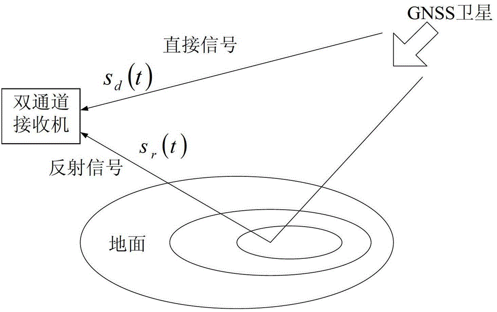
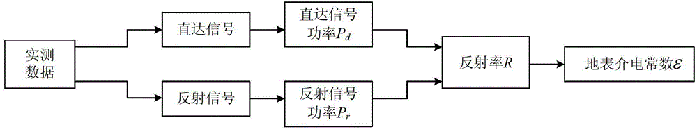
[0021] The present invention provides the accurate inversion method of soil dielectric constant that GNSS satellite reflection signal is used, such as figure 1 with figure 2 As shown, first use figure 1 The GNSS bistatic radar of GNSS receives the direct signal s of the GNSS satellite at time t respectively through the dual-channel receiver d (t), and the reflected signal s reflected by the ground r (t). Let the local signal at time t be s c (t), when the local signal completely tracks the direct signal, use the local signal s c (t) and direct signal s d (t) Carry out correlation calculations, and take its peak value as the power P of the direct signal d , the local signal s c (t) and reflected signal s r (t) Carry out correlation calculations, and take its peak value as the power P of the reflected signal r .

[0022] Then use the defini...


PUM


Abstract

The invention discloses a precise inversion method for a soil dielectric constant through a global navigation satellite system (GNSS) satellite reflection signal and belongs to the technical field of microwave remote sensing. The method comprises the following steps of: receiving a direct signal and a reflection signal of a GNSS satellite by utilizing a GNSS bistatic radar, acquiring the power of the direct signal and the reflection signal, and further acquiring the soil reflectance R; acquiring a relationship between a surface reflection coefficient and a relative soil dielectric constant; and determining the corresponding reflection coefficient and soil reflectance according to the different received reflection signals, setting an intermediate parameter, converting the formula of the soil reflectance into a quartic equation with one unknown quantity, solving the solution of the equation, and determining the soil dielectric constant. The method is wide in application range and high in inversion precision, and the soil dielectric constant can be accurately inversed, so that accurate soil humidity is obtained.

Description

technical field [0001] The invention belongs to the field of microwave remote sensing technology, and mainly relates to the inversion of soil moisture, ice and snow cover and other parameters, the inversion of marine meteorological parameters (such as sea breeze, sea wave, seawater salinity, etc.) and the detection of moving targets, etc., specifically An accurate inversion method for soil permittivity using GNSS satellite reflection signals. Background technique [0002] With the increase of GNSS satellites, its scope of application has become wider and wider. Since the end of the 20th century, some foreign research institutes have carried out remote sensing research work in the fields of ocean, soil, atmosphere, ice and other fields using GNSS. However, when using the reflection signal of the GNSS signal to invert the dielectric constant of the soil, for the sake of calculation, in the actual inversion process, only the reflectivity obtained by the vertical polarization co...

Claims


Application Information

Patent Timeline
Patent Type & Authority Applications(China)
IPC IPC(8): G01N33/24
Inventor 孙国良白永星刘嘉俊
Owner 北京卫信杰科技发展有限公司
Why Eureka
Try Eureka