Method for selecting satellite-to-ground matched data through water-color remote sensing

A technology of satellite-ground matching and data, which is applied in measuring devices, instruments, surveying and navigation, etc., can solve problems such as the inability to ensure the reliability of satellite-ground matching data, turbid water, etc., and achieve the goal of easy implementation, simple implementation, and guaranteed reliability Effect

Inactive Publication Date: 2015-06-17
NANJING UNIV OF INFORMATION SCI & TECH
View PDF2 Cites 0 Cited by
  • Summary
  • Abstract
  • Description
  • Claims
  • Application Information

AI Technical Summary

Problems solved by technology

[0006] The weather changes over the offshore sea area are more complex than the ocean, and the water body is relatively turbid. The complex hydrodynamic process causes the optical properties of the water body and the components of the water body to show high temporal and spatial changes. The existing technology is only applicable to the optical properties of the water body. In waters with relatively stable components, the reliability of star-ground matching data cannot be guaranteed in offshore waters

Method used


Image

  • Method for selecting satellite-to-ground matched data through water-color remote sensing
  • Method for selecting satellite-to-ground matched data through water-color remote sensing
  • Method for selecting satellite-to-ground matched data through water-color remote sensing

Examples


Embodiment Construction

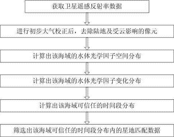
[0025] The technical scheme of the present invention will be further described in detail below in conjunction with the accompanying drawings:

[0026] Such as figure 1 As shown, this embodiment discloses a method for selecting aqua remote sensing satellite-ground matching data. The East China Sea is selected as the research area. The specific steps are as follows:

[0027] Step 1) Obtain the satellite remote sensing reflectivity data of the GOCI satellite for at least three consecutive hours in the sea area;

[0028] Step 2) After performing preliminary atmospheric correction (Rayleigh correction) on the obtained satellite remote sensing reflectance data, remove the land and pixels affected by clouds;

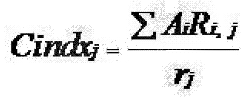
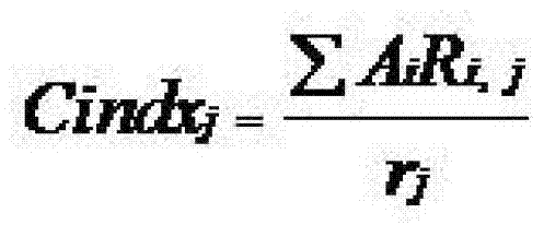
[0029] Step 3) For each satellite remote sensing reflectance data, select the data of the first band, the second band, the 4th band, the 6th band and the 8th band to calculate the spatial distribution of the water optical factor in the sea area, the water optical factor Cindx The calc...


PUM


Abstract

The invention discloses a method for selecting satellite-to-ground matched data through water-color remote sensing. The method comprises the following steps: aiming at a certain sea area, acquiring satellite remote sensing reflectance data of a static orbit satellite within a period of at least continuous three hours in the sea area; calculating the spatial distribution of optical water body factors in the sea area according to each satellite remote sensing reflectance datum; calculating the change distribution of the optical water body factors in the sea area by adopting a feature extraction algorithm to obtain credible time periods of different regions in the sea area, and further determining the satellite-to-ground matched data. The method disclosed by the invention is simple and easy to implement and capable of effectively ensuring the reliability of the satellite-to-ground matched data.

Description

Technical field [0001] The invention relates to the technical field of ocean remote sensing, in particular to a method for selecting satellite-ground matching data for water color remote sensing. Background technique [0002] Ocean water color remote sensing can simultaneously obtain information on the concentration of a wide range of water components, such as chlorophyll, suspended solids, etc. It plays an irreplaceable important role in the research and application of marine fisheries, marine ecosystems, and marine water environment. It is used for ocean surface detection. Important means. At present, the commercial operation of aqua remote sensing is mostly open oceans or water bodies with relatively uniform optical properties. In offshore waters with turbid water bodies, the application capacity and degree are relatively low, which is mainly limited by authenticity verification, that is, the selection of star-ground matching Data, compare the results of remote sensing invers...

Claims


Application Information

Patent Timeline
Patent Type & Authority Patents(China)
IPC IPC(8): G01C11/00
Inventor 丘仲锋张彪何宜军
Owner NANJING UNIV OF INFORMATION SCI & TECH
Why Eureka
Try Eureka