Unmanned aerial vehicle remote sensing image quick splicing method

A fast splicing and machine-based remote sensing technology, which is applied in image enhancement, image data processing, graphics and image conversion, etc., can solve the problems of large accumulation errors, slow processing speed, and large memory consumption, and achieve the effect of improving efficiency and speed

Active Publication Date: 2013-12-04
广州中科云图智能科技有限公司
View PDF2 Cites 9 Cited by
  • Summary
  • Abstract
  • Description
  • Claims
  • Application Information

AI Technical Summary

Problems solved by technology

[0005] In view of the above-mentioned mass sequence image stitching of UAVs, the feature-based matching method has the disadvantages of slow processing speed, large memory consumption, large accumulation errors, and poor stitching e

Method used


Image

  • Unmanned aerial vehicle remote sensing image quick splicing method
  • Unmanned aerial vehicle remote sensing image quick splicing method

Examples


Embodiment

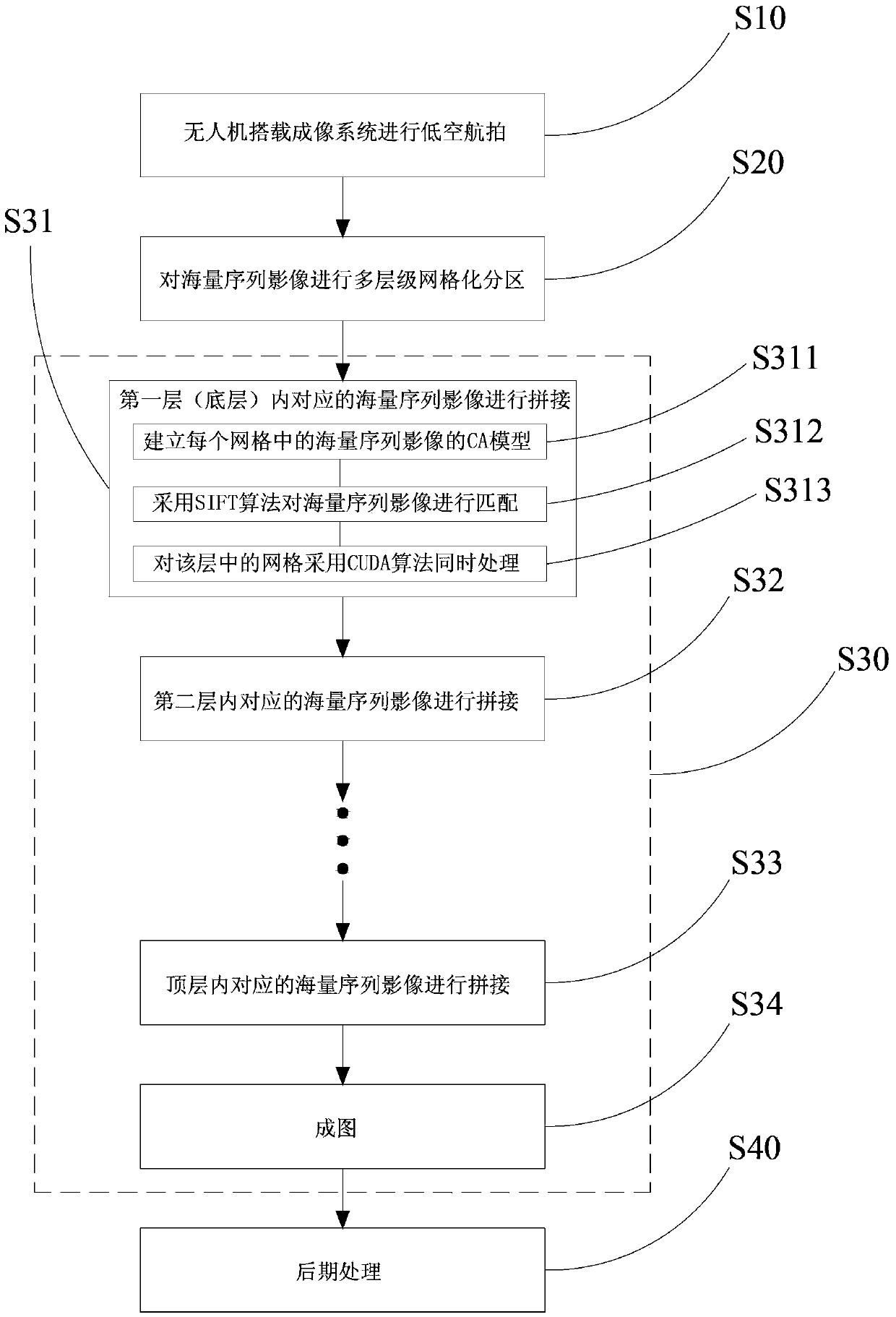
[0031] Please refer to figure 1 As shown, a method for fast stitching of UAV remote sensing images, which includes the following steps:

[0032] S10. The drone is equipped with an imaging system for low-altitude aerial photography to obtain multiple aerial photographs with massive sequence images.

[0033] Before performing step S20, pre-processing (such as geometric correction and coordinate registration, etc.) must be performed on the original aerial photographs to improve the efficiency and accuracy of mass sequence image matching.

[0034] S20. Carry out multi-level grid partitioning based on the tile pyramid model for the massive sequence images taken by aerial photography. The multi-levels are arranged in order from the bottom layer to the top layer, and each level includes at least one grid.

[0035]For aerial pictures of large areas, due to the large amount of data, the simple stitching method is not only inefficient, but also causes a very large error in the position...


PUM


Abstract

The invention discloses an unmanned aerial vehicle remote sensing image quick splicing method and relates to the technical field of image processing. The method includes the following steps: step 1, performing low-altitude aerial photographing by an imaging system mounted on an unmanned aerial vehicle; step 2, performing multilevel grid partitioning on a mass of sequence images; step 3, splicing and mapping corresponding sequence images in each level in a level-by-level manner; step 4, processing at a later stage. A CUDA (compute unified device architecture) algorithm is introduced, so that image splicing speed can be greatly increased; a CA (cellular automaton) model is utilized to optimize an SIFT (scale invariant feature transform) feature point algorithm, so that image matching efficiency and accuracy are improved.

Description

technical field [0001] The invention relates to image processing technology, in particular to a fast splicing method for remote sensing images of drones. Background technique [0002] Compared with satellite remote sensing and manned aerial remote sensing, UAV low-altitude remote sensing is faster and more flexible, especially for disaster emergency and other fields, and has incomparable advantages in satellite remote sensing and manned aerial remote sensing. UAV low-altitude remote sensing can provide the most timely high-resolution remote sensing information for earthquake relief, especially for monitoring the occurrence of secondary disasters (such as barrier lake monitoring), and provide information guarantee and data support for earthquake relief decision-making. Due to factors such as the large number of UAV remote sensing images, large and irregular inclination angles, irregular heading overlap, and large coordinate position errors, it is difficult, slow, and low-prec...

Claims


Application Information

Patent Timeline
IPC IPC(8): G06T5/50G06T3/40
Inventor 李勇张南峰杨敬锋
Owner 广州中科云图智能科技有限公司
Why Eureka
Try Eureka