Multi-source data-based urban land space information identification method

A technology of spatial information and multi-source data, applied in the field of urban land spatial information identification, can solve the problem of lack of urban land spatial information

Active Publication Date: 2013-12-11
HENAN UNIVERSITY
View PDF4 Cites 13 Cited by
  • Summary
  • Abstract
  • Description
  • Claims
  • Application Information

AI Technical Summary

Problems solved by technology

Since 1990, the Ministry of Land and Resources of China has released statistical data on the area of ​​urban land in Mainland China every year. This data reflects the total amount of urban land in each administrative unit in Mainland China. However, this data lacks spatial information on urban land, that is, urban Spatial raster data for districts
A large number of studies have shown that using satellite remote sensing image data to obtain urban land spatial information through digital image processing is an effective method for monitoring urban spatial expansion, but there is no method that can quickly and accurately obtain the required urban land spatial information.

Method used


Image

  • Multi-source data-based urban land space information identification method
  • Multi-source data-based urban land space information identification method
  • Multi-source data-based urban land space information identification method

Examples


Embodiment Construction

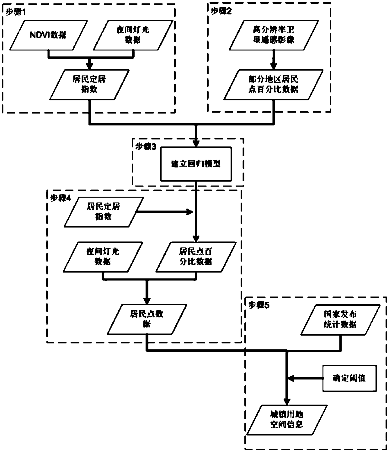
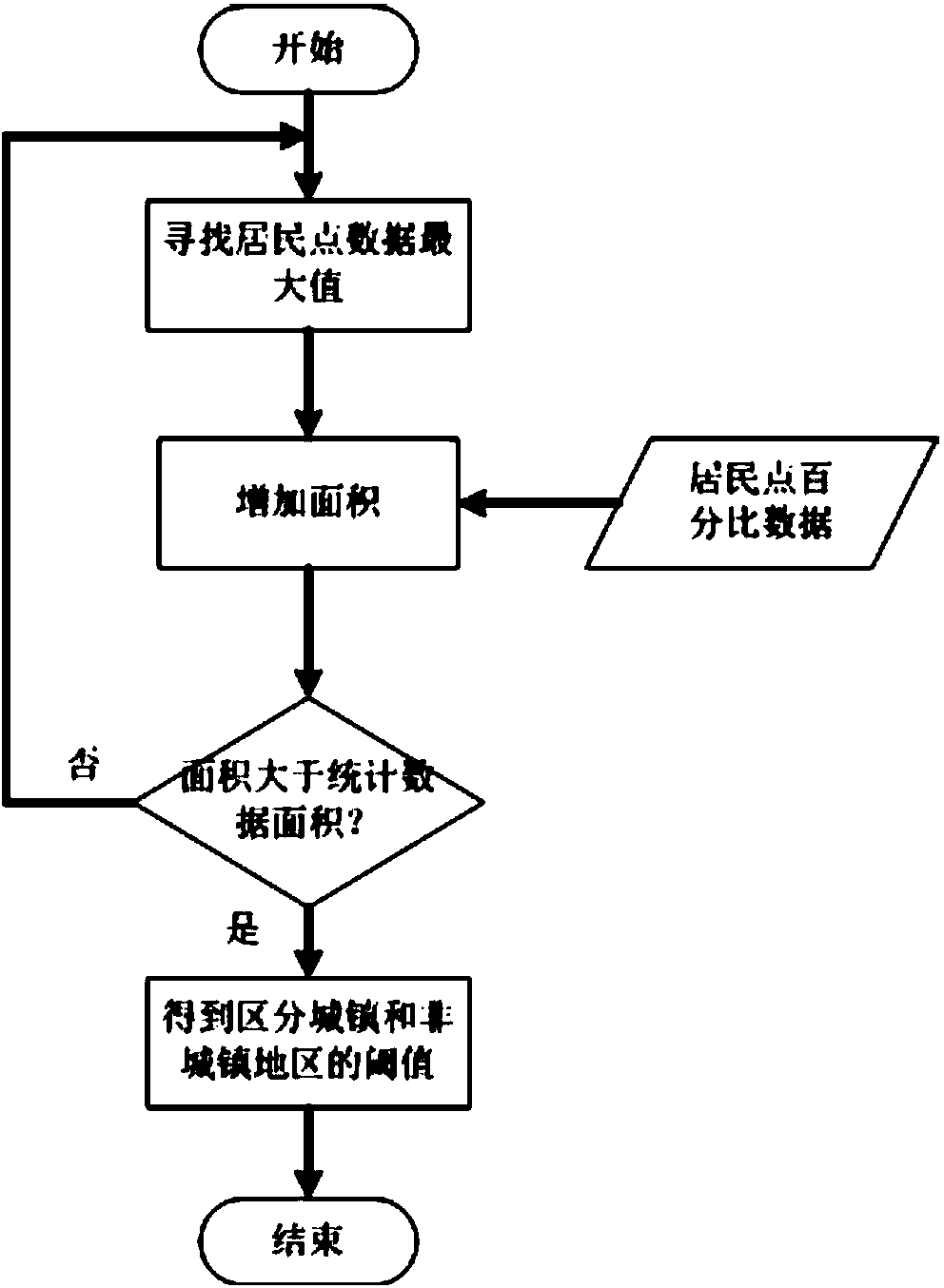
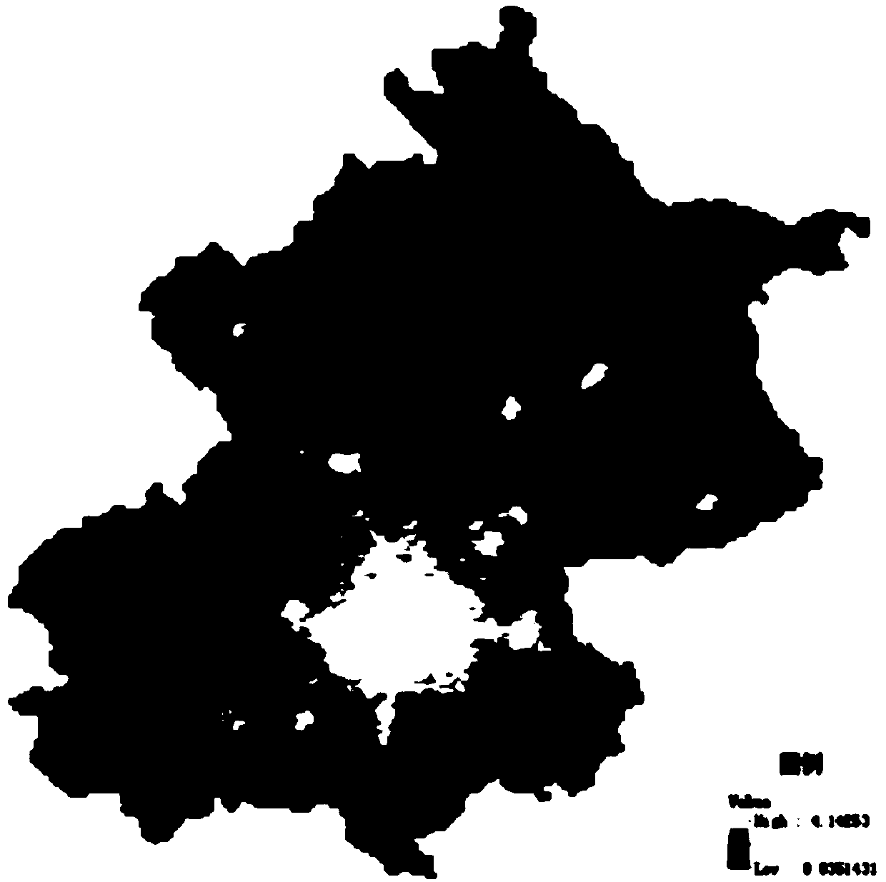
[0020] The urban land use spatial information identification method based on multi-source data first uses low-resolution satellite remote sensing images that reflect residents’ settlement information: night light and vegetation index to construct the residential settlement index; at the same time, uses high-resolution satellite remote sensing images to interpret Obtain accurate residential area percentage data based on urban land use information; on the basis of these two sets of data, establish a regression model between the residential settlement index and the residential area percentage data, and use the readily available residential settlement index to invert the residential area percentage data for the entire region , and get the residential data according to the percentage data of the residential area and the night lights; finally, the residential data is processed based on the statistical data of the urban land area released by the Ministry of Land and Resources. Such as...


PUM


Abstract

The invention relates to a multi-source data-based urban land space information identification method which comprises the following steps of: firstly, constructing a resident settlement index through night light and a vegetation index; meanwhile, interpreting urban land information by using high-resolution satellite remote sensing images in partial regions to obtain accurate settlement percentage data; based on the two sets of data, establishing a regression model of the resident settlement index and the settlement percentage data, inverting settlement percentage data in all regions by using easily available resident settlement indexes and obtaining settlement data according to the settlement percentage data and the night light; finally, processing the settlement data on the bases of standard urban land area statistical data. According to the multi-source data-based urban land space information identification method, rapid calculation is carried out by using the easily-available low-resolution data such as the night light and the vegetation index and the error between the identified urban land area and the standard urban land area statistical data is very little, thus space information of urban land can be rapidly and accurately obtained.

Description

technical field [0001] The invention relates to a method for identifying spatial information of urban land based on multi-source data. Background technique [0002] Accurately obtaining urban land use information is of great significance for understanding and understanding the process of urban evolution, improving the efficiency of land use in the process of urbanization, and reducing the risks encountered in the process of urbanization. At the same time, due to the impact of urbanization on the ecological environment around the city, timely and effective acquisition of urban land use information is also of great significance for controlling the scale of urban land use and protecting limited land resources and ecological environment. Since 1990, the Ministry of Land and Resources of China has released statistical data on the area of ​​urban land in Mainland China every year. This data reflects the total amount of urban land in each administrative unit in Mainland China. Howe...

Claims


Application Information

Patent Timeline
Patent Type & Authority Applications(China)
IPC IPC(8): G06F19/00
Inventor 卢鹤立刘桂芳
Owner HENAN UNIVERSITY
Why Eureka
Try Eureka