Method for establishing underwater landform digital elevation based on Kriging method

A digital elevation and underwater terrain technology, applied in 3D modeling, image data processing, instruments, etc., can solve problems such as unreasonable selection of water depth interpolation data and no error compensation for interpolation results.

Active Publication Date: 2014-01-22
SOUTHEAST UNIV
View PDF2 Cites 13 Cited by
  • Summary
  • Abstract
  • Description
  • Claims
  • Application Information

AI Technical Summary

Problems solved by technology

[0004] The purpose of the present invention is to: in view of the problems that existing methods directly complete the establishment of underwater terrain digital elevation from initial water depth data through interpolation methods, there are unreasonable selection of water depth interpolation data, and there is no error compensation for interpolation results. The underwater terrain digital elevation establishment method of the golden method, the underwater terrain digital elevation established by the present invention has the advantage of high precision

Method used


Image

  • Method for establishing underwater landform digital elevation based on Kriging method
  • Method for establishing underwater landform digital elevation based on Kriging method
  • Method for establishing underwater landform digital elevation based on Kriging method

Examples


Embodiment Construction

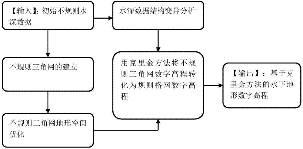
[0080] Below in conjunction with specific embodiment and accompanying drawing, further set forth the technical scheme of the present invention, should be understood that these embodiments are only used to illustrate the present invention and are not intended to limit the scope of the present invention, after having read the present invention, those of ordinary skill in the art understand this Modifications of various equivalent forms of the invention all fall within the scope defined by the appended claims of the present application.

[0081] A method for establishing digital elevation of underwater terrain based on kriging method, characterized in that:

[0082] Step 1 adopts the well-known multi-beam bathymetry method to measure the water depth value and obtain the water depth data

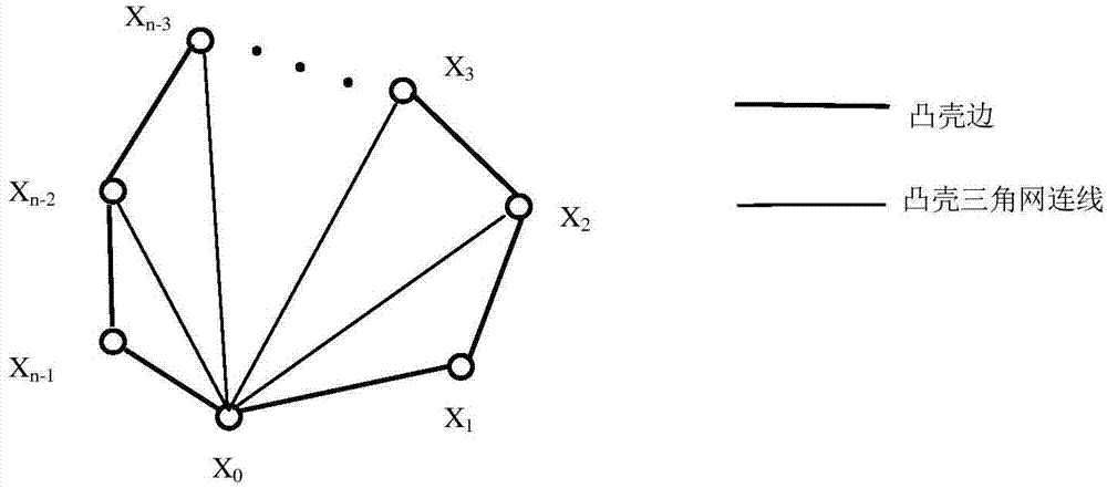
[0083] The water depth data Indicates the location A with longitude i and latitude j ij The water depth value at , step 2 to establish an irregular triangular network

[0084] From the ini...


PUM


Abstract

The invention discloses a method for establishing underwater landform digital elevation based on a Kriging method, which mainly aims to solve the problem that bigger water depth errors exist in some position points in a digital elevation establishing process when the water depth value change amplitude of the water depth data is large. The method comprises the following steps: loading initial water depth data; establishing underwater irregular triangular network landform according to the initial water depth data; performing space optimization on the irregular triangular network landform; analyzing the variable structure of the initial water depth data; performing the water depth Kriging interpolation process of the irregular triangulation network landform; performing error compensation on the water depth interpolation result. Compared with the method for directly generating regular grid digital elevation through initial water depth data interpolation, the method provided by the invention is used for selecting Kriging interpolation data to generate regular grid digital elevation through the topographic inequality of the irregular triangulation network landform, so that the problem of bigger regular grid digital elevation errors caused by large water depth value change amplitude of water depth data is solved.

Description

technical field [0001] The invention mainly relates to the field of digital elevation models of underwater topography, in particular to a method for establishing digital elevations of underwater topography based on a kriging method. Background technique [0002] The existing digital elevation establishment of underwater terrain is based on the initial water depth data, which is completed directly by interpolation method. Water depth terrain database is often directly applied to terrain-assisted navigation. Since underwater GPS signals are unreachable, the accuracy of navigation requires high accuracy of water depth terrain database. Due to the complexity of the bathymetry environment, there are systematic errors and random errors in the bathymetry data, and the initial bathymetry data after gross errors are eliminated are irregularly distributed. In the process of completing regular grid digital elevation directly from the initial water depth data interpolation, there are p...

Claims


Application Information

Patent Timeline
Patent Type & Authority Applications(China)
IPC IPC(8): G06T17/05
Inventor 徐晓苏徐胜保吴剑飞王立辉李佩娟豆嫚
Owner SOUTHEAST UNIV
Why Eureka
Try Eureka