Multispectral remote sensing image land feature classification method based on spectrum and textural features

A texture feature and feature classification technology, applied in instruments, character and pattern recognition, computer parts and other directions, can solve the problems of high noise in the classification area, difficult to classify areas, coarse texture granularity, etc., and achieve complete and good texture feature extraction. Robust, well-tolerated effects

Active Publication Date: 2014-02-05
BEIHANG UNIV
View PDF5 Cites 35 Cited by
  • Summary
  • Abstract
  • Description
  • Claims
  • Application Information

AI Technical Summary

Problems solved by technology

[0004] The existing multi-spectral remote sensing image classification methods can better classify the ground objects with small texture granularity and relatively uniform spectrum, but in high-resolution images, the texture granularity of residential areas and mountainous areas is relatively coarse and mixed. A small number of other types of ground objects are not easy to form a large classification area, and the classification area contains a lot of noise and poor consistency

Method used


Image

  • Multispectral remote sensing image land feature classification method based on spectrum and textural features
  • Multispectral remote sensing image land feature classification method based on spectrum and textural features
  • Multispectral remote sensing image land feature classification method based on spectrum and textural features

Examples


Embodiment Construction

[0036] The present invention will be further described below in conjunction with the accompanying drawings and specific embodiments.

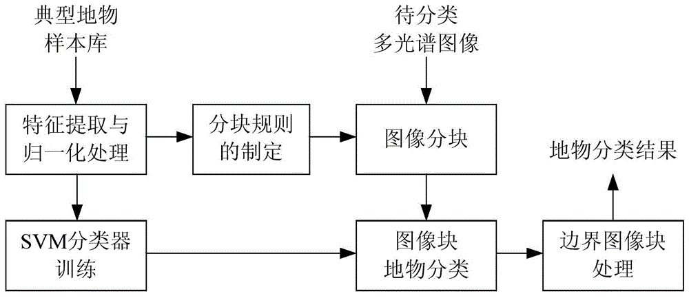
[0037] Such as figure 1 As shown, the realization of the present invention is divided into seven main steps, which are respectively: the establishment of a typical feature sample library, typical feature feature extraction and normalization processing, block feature selection and rule formulation, and image classification to be classified. Block processing, SVM classifier training, SVM-based image block classification and boundary block processing. The specific implementation steps of the present invention will be described in detail below by taking the Quickbird multi-spectral remote sensing image classification of vegetation, buildings, water bodies and other types of ground features as an example.

[0038] (1) Establishment of sample database of typical features

[0039] For the multispectral images of the same satellite to be classified, ...


PUM


Abstract

The invention discloses a multispectral remote sensing image terrain classification method based on spectrum and textural features. A quadtree partitioning technology is adopted in the method to carry out multistage partitioning processing on images, spectrum and textural features of land features are extracted in an image block mode, an SVM classifier is adopted to conduct land feature classification on image blocks, and classification marginal regions of the image blocks are processed through a region growing method. Compared with the prior art, the multispectral remote sensing image terrain classification method has the advantages that anti-noise performance of spectral signatures and textural features in land feature classification is improved, the problem of sizes of textural feature extraction windows is avoided, and classification result regions are high in consistency and low in noise.

Description

technical field [0001] The invention belongs to the technical field of digital image processing, and relates to a classification method for multi-spectral remote sensing images, in particular to a method for classifying multi-spectral remote sensing images based on spectral and texture features. A classification method for typical ground objects in high-resolution multispectral remote sensing images. Background technique [0002] Remote sensing images can reflect the situation of ground features in a large area. The classification of ground features based on remote sensing images can be applied to many aspects such as environmental monitoring, resource investigation, land planning, disaster prevention, and ground feature surveying and mapping. Multispectral remote sensing images usually have 4-7 bands. Compared with single-band panchromatic remote sensing images, more information on ground objects in blue, green, red, and near-infrared bands can be obtained, which is conduci...

Claims


Application Information

Patent Timeline
Patent Type & Authority Applications(China)
IPC IPC(8): G06K9/62
Inventor 李波胡蕾侯鹏洋
Owner BEIHANG UNIV
Why Eureka
Try Eureka