
Plotting method of fast situation plotting system based on gis platform and touch screen equipment

A touch screen and plotting technology, which is applied in the plotting field of the rapid situation plotting system, can solve the problems of single plotting content, complicated and unfavorable map plotting operation, etc., and achieve simple plotting operation, fast plotting, and rounded curves Effect

Inactive Publication Date: 2016-06-29
CLOUD COMPUTING CENT CHINESE ACADEMY OF SCI
View PDF3 Cites 0 Cited by
  • Summary
  • Abstract
  • Description
  • Claims
  • Application Information

AI Technical Summary

Problems solved by technology

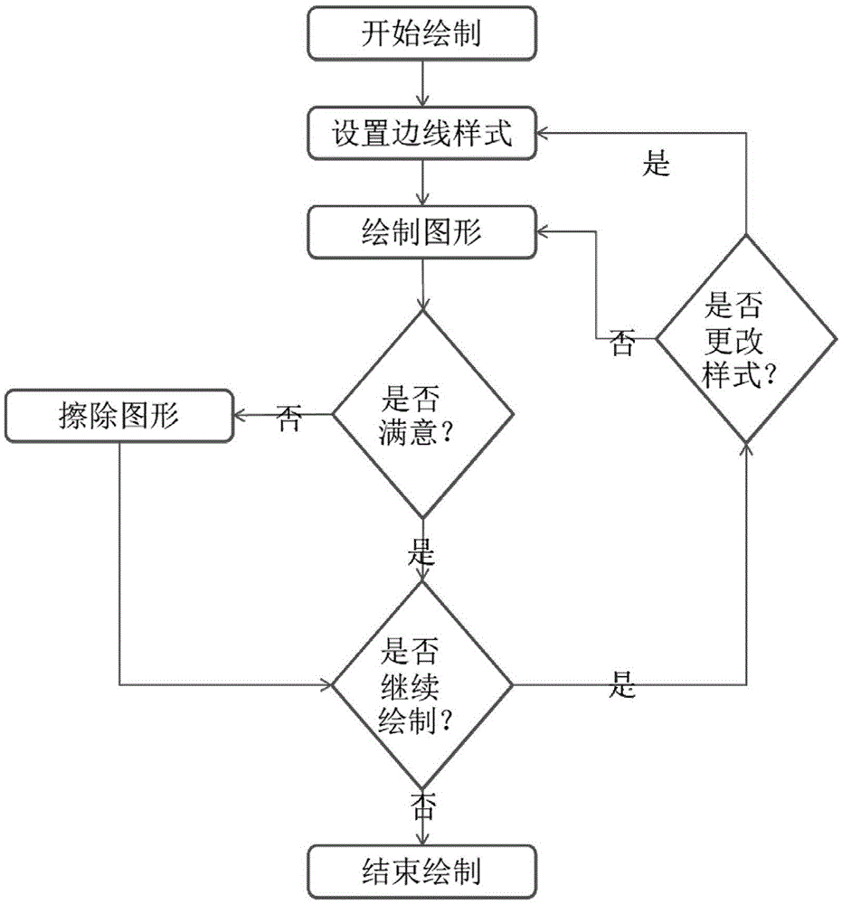
[0007] The technical problem solved by the present invention is to provide a plotting method based on a GIS platform and a touch-screen device for a fast situation plotting system, which can effectively solve the disadvantages of complex map plotting operations and single plotting content on the current geographic information platform. Operators perform real-time and intuitive graphic plotting and other issues at the emergency command site

Method used


Image

  • Plotting method of fast situation plotting system based on gis platform and touch screen equipment
  • Plotting method of fast situation plotting system based on gis platform and touch screen equipment

Examples


Embodiment Construction

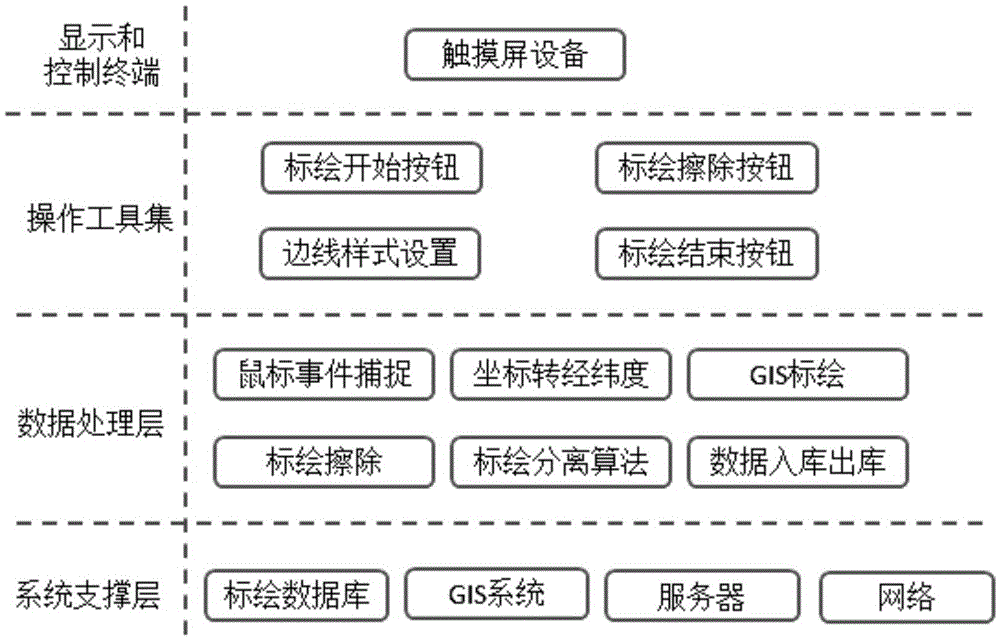
[0058] Such as figure 1 As shown, the rapid situation plotting system of the present invention is divided into 4 layers, which are display and control terminal, operation tool set, data processing layer and system support layer.

[0059] The display and control terminal is mainly used to display the GIS system and plotting content on the screen and complete the touch operation to draw graphics. The display and control terminal can be a touch operation screen or a mobile touch device.

[0060] The operation tool set mainly completes the key steps of the entire drawing process, including the start and end function buttons, the erase function button and the drawing edge style setting button.

[0061] The data processing layer lists several key plotting processing algorithms and technologies, including mouse event capture algorithm, screen coordinates and latitude and longitude mutual conversion algorithm, GIS plotting algorithm, plotting erasure processing algorithm, multiple p...


PUM


Abstract

The invention relates to the technical field of urban comprehensive emergency management, in particular to a rapid situation plotting system and method based on a GIS platform and a touch screen device. The present invention includes a display and control terminal, an operation tool set, a data processing layer and a system support layer; the display and control terminal mainly displays the GIS system and plotting content on the screen and completes touch operation to draw graphics; the operation tool set mainly completes The key steps of the entire drawing process; the data processing layer is responsible for processing the key plotting processing algorithms and technologies; the system support layer mainly includes the plotting database, GIS system, GIS server, and the network for communication between the touch screen and the server. The invention solves the problems of complicated map drawing operation and the like; it can be used for fast situation drawing of the geographical information platform.

Description

technical field [0001] The invention relates to the technical field of urban comprehensive emergency management, in particular to a plotting method of a rapid situational plotting system based on a GIS platform and a touch screen device. Background technique [0002] In recent years, all kinds of public emergencies have occurred frequently in our country. Every year, the casualties caused by public emergencies are more than one million, and the comprehensive economic loss is as high as hundreds of billions of yuan, which has caused adverse effects and serious harm to the public safety environment. Public emergencies bring heavy losses to people's lives and property, and restrict the comprehensive, coordinated and sustainable development of the national economy. Undoubtedly, a strong emergency response capability for public emergencies is the key to reducing losses and creating a good social environment. [0003] The comprehensive emergency platform based on the geographic i...

Claims


Application Information

Patent Timeline
Patent Type & Authority Patents(China)
IPC IPC(8): G06F3/0484G06F3/0488
Inventor 贺忠堂韩鸿哲李新安赵锋伟李智勇
Owner CLOUD COMPUTING CENT CHINESE ACADEMY OF SCI
Learn More