GNSS baseline solution reference satellite selecting method

A technology of reference satellite and baseline solution, applied in satellite radio beacon positioning system, radio wave measurement system, measurement device and other directions, can solve problems such as affecting feasibility and effectiveness, complex observation environment, affecting positioning results

Active Publication Date: 2014-03-12
CENT SOUTH UNIV
View PDF3 Cites 19 Cited by
  • Summary
  • Abstract
  • Description
  • Claims
  • Application Information

AI Technical Summary

Problems solved by technology

However, when the reference satellite has abnormal observations, this effect will be brought into all double-difference observation equations, thereby affecting the positioning results
The observation environment in deformation monitoring is relatively complex, which will seriously affect the feasibility and effectiveness of the method

Method used


Image

  • GNSS baseline solution reference satellite selecting method
  • GNSS baseline solution reference satellite selecting method
  • GNSS baseline solution reference satellite selecting method

Examples


Embodiment Construction

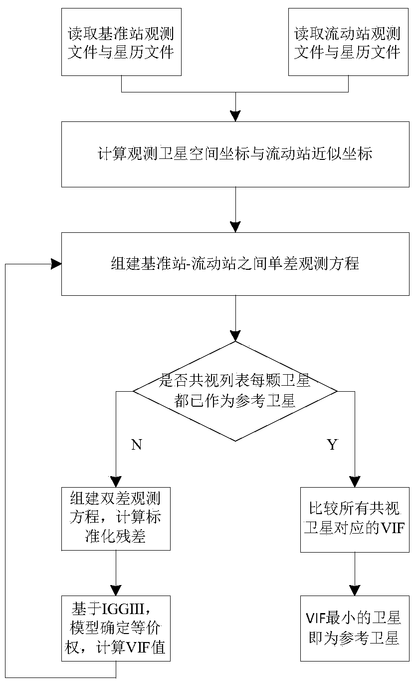
[0035] Such as figure 1 Shown, the concrete steps of the present invention are as follows:

[0036] 1) Use the base station and rover observation data and ephemeris files collected by the GNSS receiver, use the ephemeris files to solve the observation satellite space coordinates, use the pseudo-range positioning method to calculate the approximate coordinates of the rover, and establish the base station and rover Phase observation equation, as shown in formula (1):

[0037] L I p = ρ I p + c · ( dts p - dtr ...


PUM


Abstract

The invention discloses a global navigation satellite system (GNSS) baseline solution reference satellite selecting method. The method mainly comprises the steps of establishing an inter-station difference single-difference model according to a GNSS carrier phase observation equation, and weakening influence from spatial correlation error; selecting a satellite according to base station and moving station common-view observation satellite list to construct a dual-difference model, resetting weight of each dual-difference observation value through an equivalent weight model based on an IGGIII model, and inhibiting influence from observation abnormity through a robust estimation model; calculating a variance inflation factor corresponding to each common-view satellite as a reference satellite according to the established dual-difference model; and calculating a VIF value to determine the reference satellite. The method, compared to an existing method, not only takes distribution structure of a spatial satellite into consideration but also focuses on quality of the observation value; therefore, the method can determine the most reasonable reference satellite and greatly improve both positioning accuracy and reliability.

Description

technical field [0001] The invention relates to a method for selecting a reference satellite for GNSS baseline calculation, in particular to a method for selecting a reference satellite for GNSS relative positioning. Background technique [0002] When calculating the GNSS baseline, the selection of reference satellites is an important issue. The selection of reference satellites directly affects the accuracy and reliability of positioning. The general strategy for selecting reference satellites is to select the satellite with the largest satellite elevation angle. Due to the highest altitude angle of the satellite, theoretically, the satellite observation data is least affected by error sources such as atmospheric delay and multipath effect, and the error introduced by the reference satellite when constructing the double-difference model is also the smallest. However, the altitude angle is not the only factor affecting the satellite distribution structure, so it is not appr...

Claims


Application Information

Patent Timeline
Patent Type & Authority Applications(China)
IPC IPC(8): G01S19/28
CPCG01S19/28G01S19/42
Inventor 戴吾蛟高晓匡翠林陈玉林
Owner CENT SOUTH UNIV
Why Eureka
Try Eureka