Vehicle navigation system and vehicle navigation method

A vehicle navigation system and vehicle navigation technology, applied in navigation, surveying and mapping and navigation, road network navigator, etc., can solve the problem that navigation rules cannot meet user navigation in time, and achieve the effect of saving driving time and reducing vehicle energy consumption

Inactive Publication Date: 2014-04-09
SHANGHAI ONSTAR TELEMATICS
View PDF3 Cites 37 Cited by
  • Summary
  • Abstract
  • Description
  • Claims
  • Application Information

AI Technical Summary

Problems solved by technology

Changes in these dynamic restriction policies and rules require the support of a dynamic restric...

Method used


Image

  • Vehicle navigation system and vehicle navigation method
  • Vehicle navigation system and vehicle navigation method

Examples


Embodiment 1

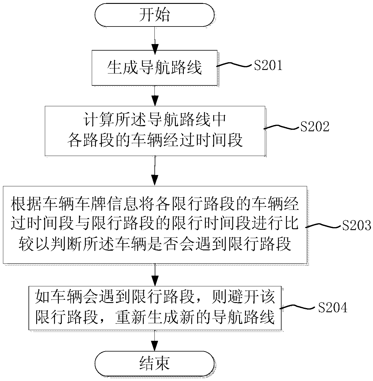
[0034] figure 2 It is a schematic diagram of the vehicle navigation flow in the embodiment of the present invention.

[0035] See figure 2 , the vehicle navigation steps provided by the present invention are as follows:

[0036] Step 201, generating a navigation route.

[0037] First, the navigation server will create user information data in the vehicle owner registration information management system during user registration, including vehicle information such as name, city, license plate number, and vehicle frame number. At the same time, a traffic restriction policy database will be established on the server, including the traffic restriction area (a collection of road sections in the area), the traffic restriction time period, the registration place of the traffic restriction license plate, the tail number of the traffic restriction license plate and other traffic restriction rule information. The database may have recorded the owner's vehicle information as the defa...

Embodiment approach

[0058] Example 1

[0059] First, the navigation server will create user information data in the vehicle owner registration information management system during user registration, including vehicle information such as name, city, license plate number, and vehicle frame number. At the same time, a traffic restriction policy database will be established on the server, including the traffic restriction area (a collection of road sections in the area), the traffic restriction time period, the registration place of the traffic restriction license plate, the tail number of the traffic restriction license plate and other traffic restriction rule information. The database may have recorded the owner's vehicle information as the default vehicle information when the user registered. In this embodiment, the default license plate number attribution information is used as the owner's vehicle information.

[0060] When the vehicle makes a route calculation request, it will request the voice...

Embodiment 2

[0068] The generation of the navigation route is the same as described in Embodiment 1, and the final generated route is estimated to travel for 100 minutes. The travel time limit is 60 minutes. Assuming that the vehicle needs to pass through the restricted area completely, the start time is 50 minutes before the start of the restricted area. It is estimated that it will take 20 minutes to reach the entrance of the restricted area.

[0069] After the system generates the original route, it will compare the starting time interval of the route with the restricted time interval, and it will be concluded that 20 minutes after the trigger, there will be at least 40 minutes of restricted travel. At this time, the tolerance value preset by the system is greatly exceeded, and the road section will be avoided. But for the new route that avoids the restricted area, the travel time of the new route will be calculated again, and the 40-minute restricted section will be subtracted. After...


PUM


Abstract

The invention discloses a vehicle navigation system and a vehicle navigation method. The vehicle navigation method comprises the following steps: generating a navigation route; calculating vehicle passing time periods of all road sections in the navigation route; according to vehicle license information, comparing the vehicle passing time periods of vehicles at traffic control roads with the traffic control time periods of the traffic control roads so as to judge whether the vehicles can encounter the traffic control roads; if yes, keeping off the traffic control road and regenerating a new navigation route; when judging whether the vehicles can encounter the traffic control roads, combining the departure time point, a preset city traffic control time period and a preset city traffic control road of the navigation route, so as to judge whether the route in the current time can encounter the traffic control limit. According to the vehicle navigation system and the vehicle navigation method, the traffic control roads can be timely kept off according to the traffic control information of the roads, route planning can be aided more reasonably and effectively so as to save the traveling time of a user, and reduce the energy consumption of an automobile.

Description

technical field [0001] The invention relates to vehicle navigation technology, in particular to a vehicle navigation system and a vehicle navigation method. Background technique [0002] The current urban congestion problem is becoming more and more serious, and some cities have to introduce vehicle restriction measures. For the vehicle restriction policy, there is currently a simple method in the market to avoid special road sections before navigating, but when encountering a road that is far away from the entrance of the restricted area Situations, such as inter-city driving routes, or want to be more flexible to partially evade according to the traffic restriction policy, still lack a smarter navigation method to meet the needs of improving driving efficiency. [0003] If you are new to an unfamiliar city and are not familiar with traffic restrictions, or the navigation device cannot plan a reasonable driving route when you encounter traffic restrictions during the local ...

Claims


Application Information

Patent Timeline
IPC IPC(8): G01C21/34
CPCG01C21/3461G01C21/3415
Inventor 洪杰俞云
Owner SHANGHAI ONSTAR TELEMATICS
Why Eureka
Try Eureka