City navigation system construction method based on positioning two-dimensional codes and city navigation system based on positioning two-dimensional codes

A navigation system and construction method technology, applied in the field of navigation, can solve the problem of accurate data (a large amount of micro-navigation data, which cannot effectively meet the user's short-distance, precise positioning and navigation needs, hand-held navigators, mobile phones to find people and ask directions, etc. question

Active Publication Date: 2014-04-09
深圳华科育成科技开发有限公司
View PDF4 Cites 29 Cited by
  • Summary
  • Abstract
  • Description
  • Claims
  • Application Information

AI Technical Summary

Problems solved by technology

Although various navigation devices and mobile phone navigation software are becoming more and more popular, at the micro level, they cannot effectively meet users' short-distance and precise positioning and navigation needs, resulting in the situation where hand-held navigators and mobile phones are still constantly looking for people to ask for directions
The main reason is that users cannot obtain accurate data of their own current accurate spatial location and surrounding places, roads and facilities (the amount of micro-navigation data is large, and it is impossible to download and store it in the user terminal at one time), so that they cannot obtain information about their location and target. Efficient and precise navigation guidance for directions
On the other hand, for indoor and underground places, due to the lack of positioning signals such as GPS, it is difficult to effectively carry out navigation services

Method used


Image

  • City navigation system construction method based on positioning two-dimensional codes and city navigation system based on positioning two-dimensional codes
  • City navigation system construction method based on positioning two-dimensional codes and city navigation system based on positioning two-dimensional codes

Examples


Embodiment Construction

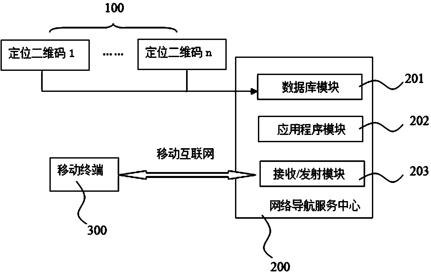
[0030] As mentioned above, the purpose of the present invention is to solve the problem that the city navigation service in the prior art cannot effectively meet the user's short-distance, precise positioning and navigation needs at the micro level, and proposes a location-based two-dimensional code The construction method of the urban navigation system and the corresponding navigation system use the QR code scanning method to accurately locate the user itself, and at the same time obtain the detailed spatial data around the user's current location through the wireless Internet, and perform microcosmic precise navigation according to the target input by the user.

[0031] The present invention will be further described below with reference to the accompanying drawings.

[0032] refer to figure 1 , a flow chart of the steps of a method for constructing a city navigation system based on a positioning two-dimensional code provided in this embodiment. Such as figure 1 As shown, ...


PUM


Abstract

The invention discloses a city navigation system construction method based on positioning two-dimensional codes. The method comprises steps that: (a), multiple positioning two-dimensional codes are arranged in a city, and the positioning two-dimensional codes are numbered; (b), space plotting for each positioning two-dimensional code is carried out to acquire accurate space coordinate information and geography environment information, and the space coordinate information relates to longitude and latitude coordinates; (c), the space coordinate information and the geography environment information are inputted to a database, and integration of the information is carried out to form an application program; and (d), a mobile terminal is utilized by a user to scan the positioning two-dimensional codes to acquired the space coordinate information and the geography environment information of corresponding positions. The invention further provides a city navigation system based on the positioning two-dimensional codes, and the city navigation system corresponds to the method. According the method and the system, accurate self-positioning of the user is carried out through a two-dimensional code scanning mode, detailed space data around the present position of the user is acquired simultaneously through the mobile Internet, and accurate navigation of a microscopic environment is carried out according to an object inputted by the user.

Description

technical field [0001] The invention relates to the technical field of navigation, in particular to a method for constructing a city navigation system based on a positioning two-dimensional code and a navigation system. Background technique [0002] At present, the development of electronic map has been very fast, and it has replaced the traditional physical map in many places. The existing electronic map can not only show the regional distribution and route diagram of the location to the user, but also has the function of navigation, that is, after the user enters the starting location and destination location, the electronic map can plan the route and display it to the customer, which can be applied in the city navigation service. The current city navigation service is suitable for the macro level, but lacks effectiveness for the micro level (within 200 meters). Although various navigation devices and mobile phone navigation software are becoming more and more popular, a...

Claims


Application Information

Patent Timeline
Patent Type & Authority Applications(China)
IPC IPC(8): G06K7/10G01C21/00
Inventor 修文群
Owner 深圳华科育成科技开发有限公司
Why Eureka
Try Eureka