Farmland operation area boundary point and unmanned helicopter position point drawing method

A technology for unmanned helicopter, work area

Active Publication Date: 2014-04-16
CENT SOUTH UNIV
View PDF9 Cites 33 Cited by
  • Summary
  • Abstract
  • Description
  • Claims
  • Application Information

AI Technical Summary

Problems solved by technology

[0010] The outline map of the farmland operation area drawn by remote sensing map-assisted surveying and mapping technology is just a static map. For the operator of the unmanned helicopter, the auxiliary function of this map can only provide a rough reference. In most cases, there is no Human helicopter operators can only judge whether the unmanned helicopter has flown out of the border of the farmland work area through their own experience and intuition or by arranging manpower at the border of the farmland work area, which is neither intuitive nor reliable

Method used


Image

  • Farmland operation area boundary point and unmanned helicopter position point drawing method
  • Farmland operation area boundary point and unmanned helicopter position point drawing method
  • Farmland operation area boundary point and unmanned helicopter position point drawing method

Examples


Embodiment Construction

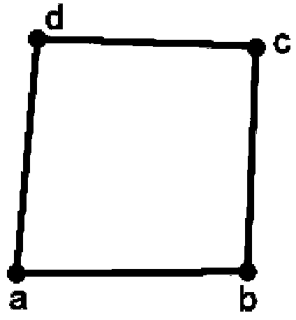
[0038] Such as figure 1 As shown, the present invention takes the quadrilateral farmland boundary of any shape to draw the farmland operation area as an example, assuming that the farmland operation area is as figure 1 shown. Where a, b, c, d are boundary points.

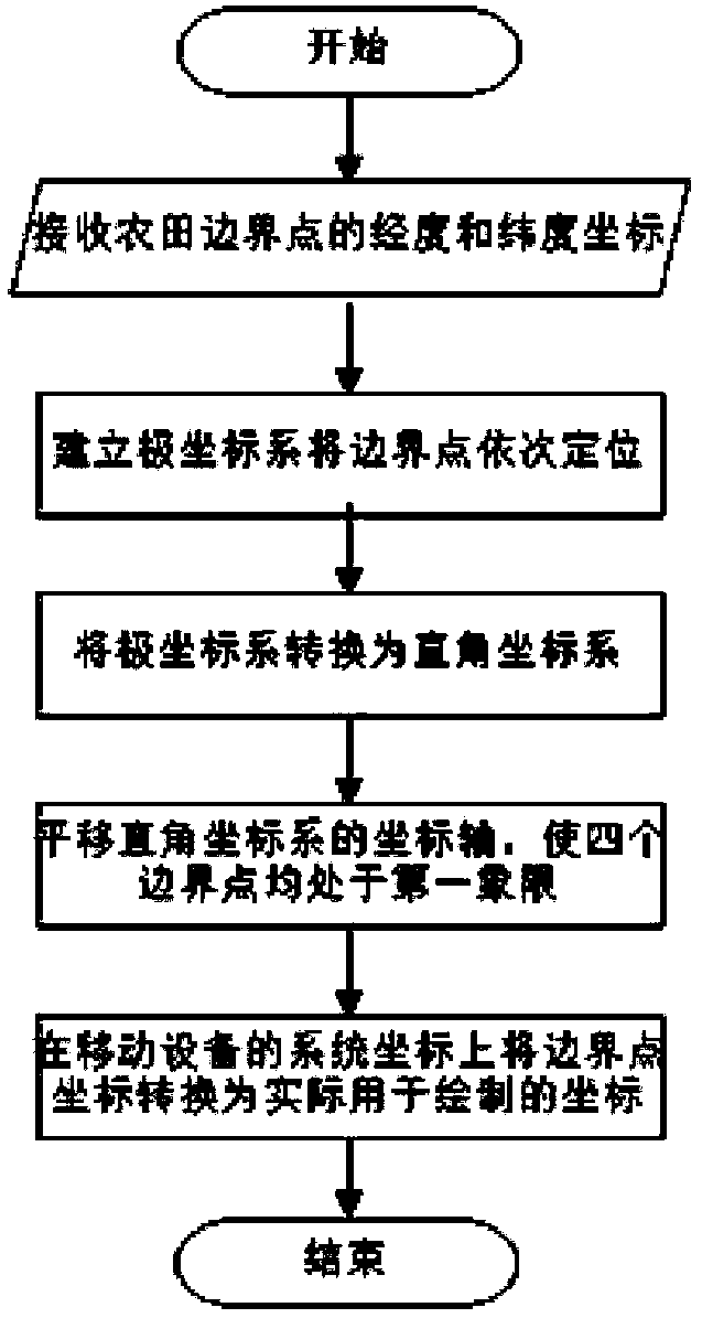
[0039] Method flow chart of the present invention is as figure 2 As shown, it is divided into the following four steps:

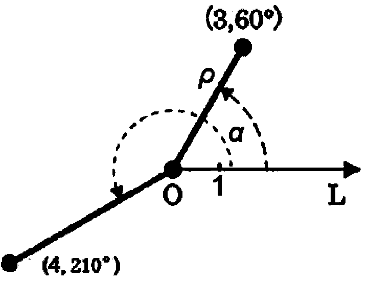
[0040] Step 1: Receive the longitude and latitude coordinates of the farmland boundary points uploaded from the handheld GPS device to the mobile device, and establish a polar coordinate system based on this to position the boundary points sequentially, and record it as coordinate system A.

[0041] Determining a point in the polar coordinate system requires two parameters: f(ρ,α)=0. Among them, ρ represents the distance (polar distance) between a point and the origin O of polar coordinate A, and α represents the angle between a point and the origin O and the polar axis in the counterclockwi...


PUM


Abstract

The invention discloses a farmland operation area boundary point and unmanned helicopter position point drawing method. The method includes the steps of determining an appropriate coordinate transformation system according to longitude and latitude information uploaded to a mobile device through a GPS module and a handheld GPS device which are carried by an unmanned helicopter, correctly expressing a farmland operation area boundary point, represented by the longitude transmitted by the handheld GPS device and the latitude transmitted by the handheld GPS device, as a coordinate point in a two-dimensional rectangular coordinate system with scales, drawing a farmland operation area boundary on a screen display program of the mobile device, converting the point represented by the longitude transmitted by the handheld GPS device of the unmanned helicopter and the latitude transmitted by the handheld GPS device of the unmanned helicopter into the coordinate point in the two-dimensional rectangular coordinate system where a farmland operation area is located, and drawing the real-time flight path of the unmanned helicopter. The farmland operation area boundary drawn through the method is extremely high in accuracy, good in instantaneity and high in reliability; the operation difficulty of an unmanned helicopter controller is greatly lowered, the air safety coefficient of the unmanned helicopter is increased, and the mechanical work efficiency is improved.

Description

technical field [0001] The invention relates to a method for drawing boundary points of farmland operation areas and position points of unmanned helicopters. Background technique [0002] Under the vigorous promotion of the Ministry of Agriculture, the level of mechanization of plowing, sowing, and harvesting in my country has been significantly improved in recent years, but pesticide spraying (especially rice pesticide spraying) is basically still a traditional manual operation. my country is a large agricultural country. How to effectively prevent agricultural pests has become one of the important goals of my country's agricultural production. Especially in the process of promoting green agriculture and precision agriculture, the low-cost, accurate and high The mechanization and automation of environmentally friendly pesticide spraying has become an essential technology, and the use of small unmanned helicopters for pesticide spraying is the best choice for mechanized pesti...

Claims


Application Information

Patent Timeline
Patent Type & Authority Applications(China)
IPC IPC(8): G01S19/39G01S19/42
CPCG01S19/42
Inventor 谭冠政刘振焘肖斯诺胡建中黄宇李凯旷世
Owner CENT SOUTH UNIV
Why Eureka
Try Eureka