Multi-information fusion positioning method and apparatus

A technology of multi-information fusion and positioning method, applied in satellite radio beacon positioning systems, measurement devices, instruments, etc., can solve the problems of expensive inertial devices, time error accumulation effect, map matching failure, etc., to expand positioning coverage Scope, effect of high commercial value

Inactive Publication Date: 2014-04-23
BEIJING UNIV OF POSTS & TELECOMM
View PDF4 Cites 24 Cited by
  • Summary
  • Abstract
  • Description
  • Claims
  • Application Information

AI Technical Summary

Problems solved by technology

The problem with this solution is that the output of ordinary inertial devices has an error accumulation effect over time, and the high-precision inertial devices are expensive, which is not suitable for civilian use; at the same time, the current map matching technology cannot output satellite positioning results. Map matching will then fail

Method used


Image

  • Multi-information fusion positioning method and apparatus
  • Multi-information fusion positioning method and apparatus
  • Multi-information fusion positioning method and apparatus

Examples


Embodiment Construction

[0030] The technical solutions of the present invention will be further elaborated below with reference to the accompanying drawings and specific embodiments.

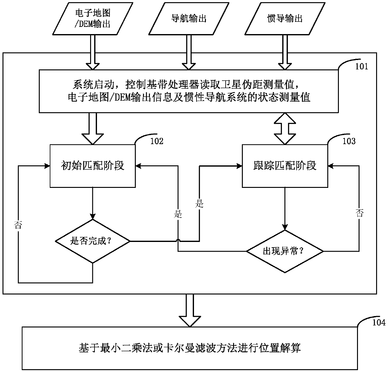
[0031] figure 1 It is a schematic flowchart of the multi-information fusion positioning method of the present invention, such as figure 1 As shown, the method includes the following steps:

[0032] Step 101, read satellite data, inertial navigation, and map data. Specifically:

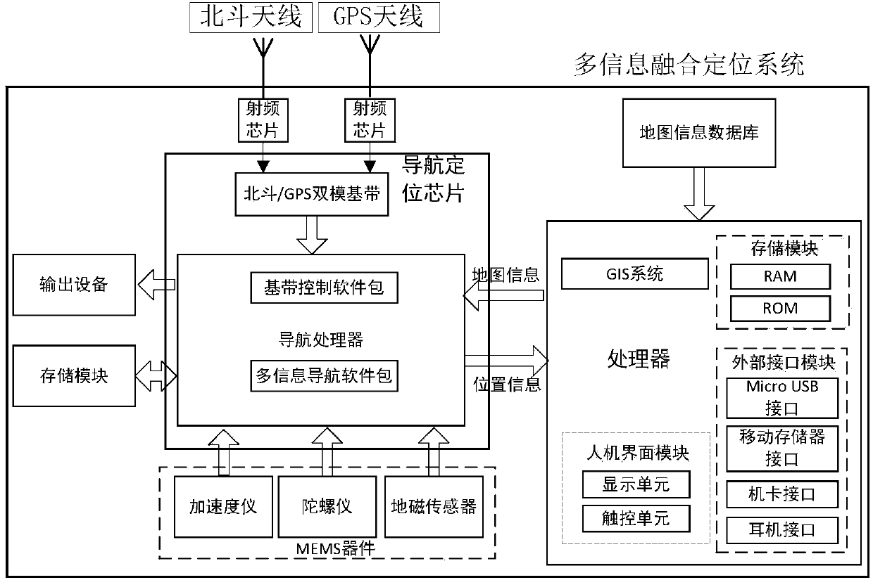
[0033] When the system starts, the satellite processing module receives the satellite signal, and after the tracking channel is ready for the measurement value, it sends an interrupt to the processor. The processor reads measurement values ​​from the tracking channel, and the measurement values ​​include code measurement values ​​and carrier measurement values. Read inertial navigation data and map data; select the positioning method according to the number of satellites and user settings, including satellite positioning, inertial navigatio...


PUM


Abstract

The invention discloses a multi-information fusion positioning method. A satellite observation value is read from a satellite signal processor so as to generate a pseudo-range equation; and dynamic information including a direction vector, a speed, an accelerated speed, and a jerk and the like is read from an inertial navigation system and data including a road topology structure, a road direction vector, a road length, and electronic elevation and the like are read from a digital map and an elevation database. Initial matching is completed according to the pseudo range as well as the dynamic information, direction information, the road topology and direction that are outputted by the inertial navigation device; and a positioning model is formed based on the initial matching result, wherein the positioning model includes the pseudo-range equation, the road vector equation and the electronic elevation constraint equation and the like; and position calculation is carried out by using the least square method or the Kalman filtering algorithm. In addition, the invention also provides an apparatus for realizing the method. Therefore, a positioning problem of a satellite signal in a shielded environment can be effectively solved; and the positioning coverage range of the satellite navigation is expanded. And thus the method and the apparatus have the high commercial value.

Description

technical field [0001] The invention relates to the technical field of satellite positioning and inertial navigation, in particular to a method and a device for positioning by fusing satellite pseudoranges, inertial navigation data and maps. Background technique [0002] After more than 30 years of development of satellite navigation technology, especially the research and application of high-sensitivity navigation signal reception technology, the usable range of satellite navigation has been greatly expanded. In areas where satellite signal occlusion is not too serious, satellite navigation can meet general navigation and positioning needs. However, in urban canyons or other areas where the signal is severely blocked, the satellite signal can be attenuated by 20-40 dB or even disappear completely. At this time, satellite navigation will encounter great challenges: first, the attenuation of the signal makes it difficult to capture and track the signal, and causes a large bi...

Claims


Application Information

Patent Timeline
Patent Type & Authority Applications(China)
IPC IPC(8): G01S19/42G01S19/45G01S19/49
CPCG01C21/165G01S19/49
Inventor 路卫军刘利权
Owner BEIJING UNIV OF POSTS & TELECOMM
Why Eureka
Try Eureka