Block adjusting method of satellite image of three-line array

A technology of block network adjustment and satellite imagery, applied in photogrammetry/video metrology, measuring devices, instruments, etc., can solve the problem that parameters do not have strict geometric meaning

Active Publication Date: 2014-04-30
SATELLITE SURVEYING & MAPPING APPL CENTSASMAC NAT ADMINISTATION OF SURVEYING MAPPING & GEOINFORMATION OF CHINANASG
View PDF7 Cites 31 Cited by
  • Summary
  • Abstract
  • Description
  • Claims
  • Application Information

AI Technical Summary

Problems solved by technology

The RPC-based model has the advantages of high simulation accuracy, good versatility, convenient a

Method used


Image

  • Block adjusting method of satellite image of three-line array
  • Block adjusting method of satellite image of three-line array
  • Block adjusting method of satellite image of three-line array

Examples


Embodiment Construction

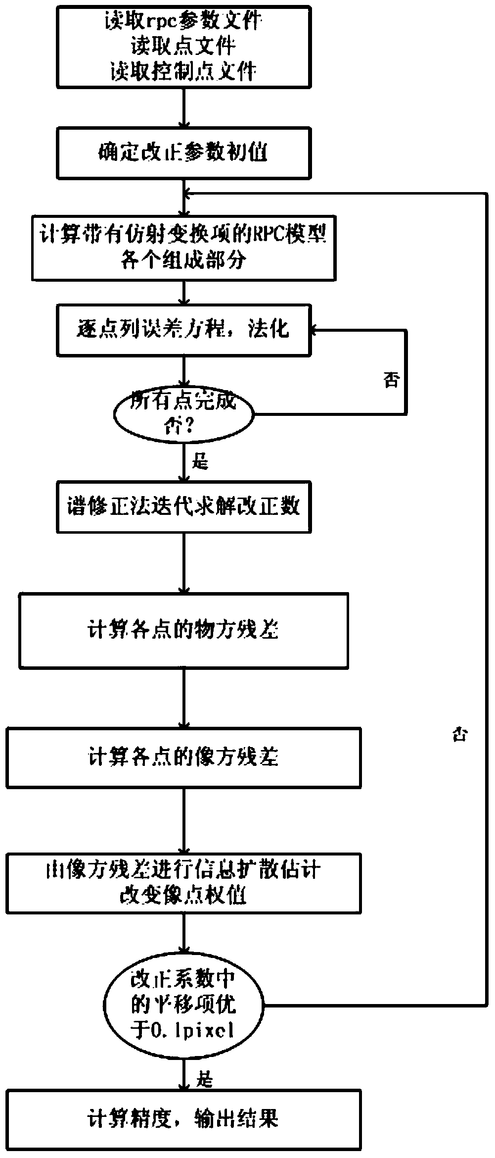
[0035] The present invention will be described in detail below in conjunction with the accompanying drawings and embodiments.

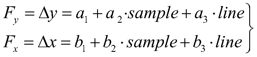
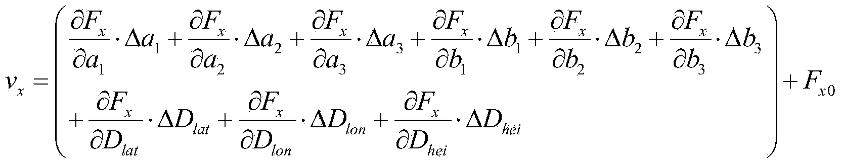
[0036] Such as figure 1 As shown, the three-line array satellite image block adjustment method of the present invention is aimed at the CCD linear array push-broom optical satellite image, and uses scarce (lack) control points to perform block adjustment. While solving the image square correction model, it solves The ground point coordinates of all pending points (checkpoints), which include the following steps:

[0037] 1) Read the satellite CCD array image, use matching technology or manual collection to select the same-name point in the overlapping area of ​​adjacent satellite images as the connection point between the images, and puncture the control points and Checkpoints, and save the coordinate information of connection points, control points and checkpoints into corresponding point files; among them, the principle of control point layout shou...


PUM


Abstract

The invention relates to a block adjusting method of a satellite image of a three-line array. The method comprises the following steps: (1) reading the satellite image and storing coordinate information of all types of points as corresponding point documents; (2) reading the documents to obtain an RPC (Remote Position Control) model as well as ground coordinates and image coordinates of a control point and a check point and image point coordinates of a connecting point; (3) determining the initial value of a ground point coordinate and image space conversion model; (4) constructing an error equation point by point and normalizing; (5) solving a corrected parameter and coordinates of a ground point for a normal equation by means of spectral correction by iterative estimation; (6) calculating the object space precision achieved after adjusting iteration at the time; (7) calculating the image space precision after adjusting iteration at the time, and determining the weight P of a coordinate observation value of an iterative image point at the next time by means of an information diffusion model through image space residue; (8) when translation parameters in orientation parameters are less than a threshold value, finishing adjusting iteration; if the predetermined condition is not satisfied, continuing iterating till iteration is finished; and (9) when the whole balancing iteration is finished, outputting a precision report on the most adjusting object space and image space precisions.

Description

technical field [0001] The invention relates to the technical field of photogrammetry, in particular to a three-line array satellite image block adjustment method. Background technique [0002] High-resolution push-broom sensors can acquire high-resolution remote sensing images. Current high-resolution satellite remote sensing images are basically acquired based on this special imaging method. Since the beginning of the 21st century, more and more high-resolution commercial satellites have been successfully launched, providing users with a variety of data source options. However, due to the different design of each satellite sensor, the practicability of the acquired satellite images is greatly limited. Therefore, in order to establish a strict one-to-one correspondence between image coordinates and ground coordinates, it is necessary to establish an imaging geometric model of the image. At present, the commonly used imaging geometric models are mainly divided into two typ...

Claims


Application Information

Patent Timeline
IPC IPC(8): G01C11/00
CPCG01C11/04
Inventor 张过唐新明汪韬阳高小明潘红播王霞胡芬
Owner SATELLITE SURVEYING & MAPPING APPL CENTSASMAC NAT ADMINISTATION OF SURVEYING MAPPING & GEOINFORMATION OF CHINANASG
Why Eureka
Try Eureka