Image generating method and system based on infrared remote sensing data

A technology for remote sensing data and remote sensing images, applied in the field of aerospace remote sensing, can solve problems such as high cost, remote sensing images cannot meet demand, and remote sensing images cannot be obtained.

Active Publication Date: 2014-04-30
BEIJING INST OF ENVIRONMENTAL FEATURES
View PDF2 Cites 12 Cited by
  • Summary
  • Abstract
  • Description
  • Claims
  • Application Information

AI Technical Summary

Problems solved by technology

[0005] However, the remote sensing images in the infrared band taken by a single space-borne camera sometimes cannot meet the demand: suppose that the infrared remote sensing images with a resolution of 10m are required, then the HRV carried by the French SPOT satellite is the satellite that meets the resolution requirements. However, since HRV has fewer infrared bands fo

Method used


Image

  • Image generating method and system based on infrared remote sensing data
  • Image generating method and system based on infrared remote sensing data
  • Image generating method and system based on infrared remote sensing data

Examples


Embodiment Construction

[0046] In order to make the object, technical solution and advantages of the present invention clearer, the present invention will be described in further detail below with reference to the accompanying drawings and preferred embodiments. However, it should be noted that many of the details listed in the specification are only for readers to have a thorough understanding of one or more aspects of the present invention, and these aspects of the present invention can be implemented even without these specific details.

[0047] As used herein, terms such as "module" and "system" are intended to include computer-related entities such as, but not limited to, hardware, firmware, a combination of hardware and software, software, or software in execution. For example, a module may be, but is not limited to being limited to being, a process running on a processor, a processor, an object, an executable, a thread of execution, a program, and / or a computer. For example, both an applicatio...


PUM


Abstract

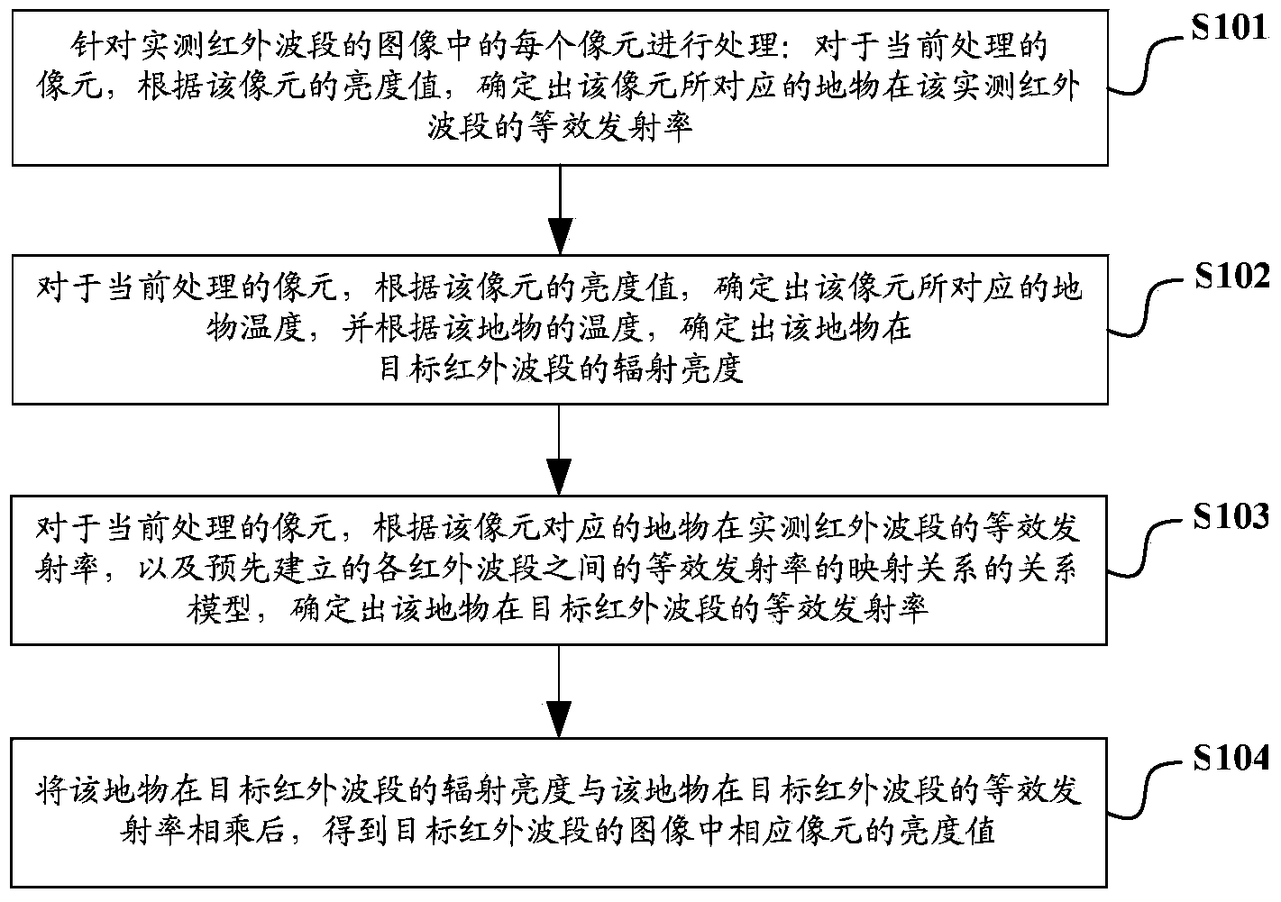
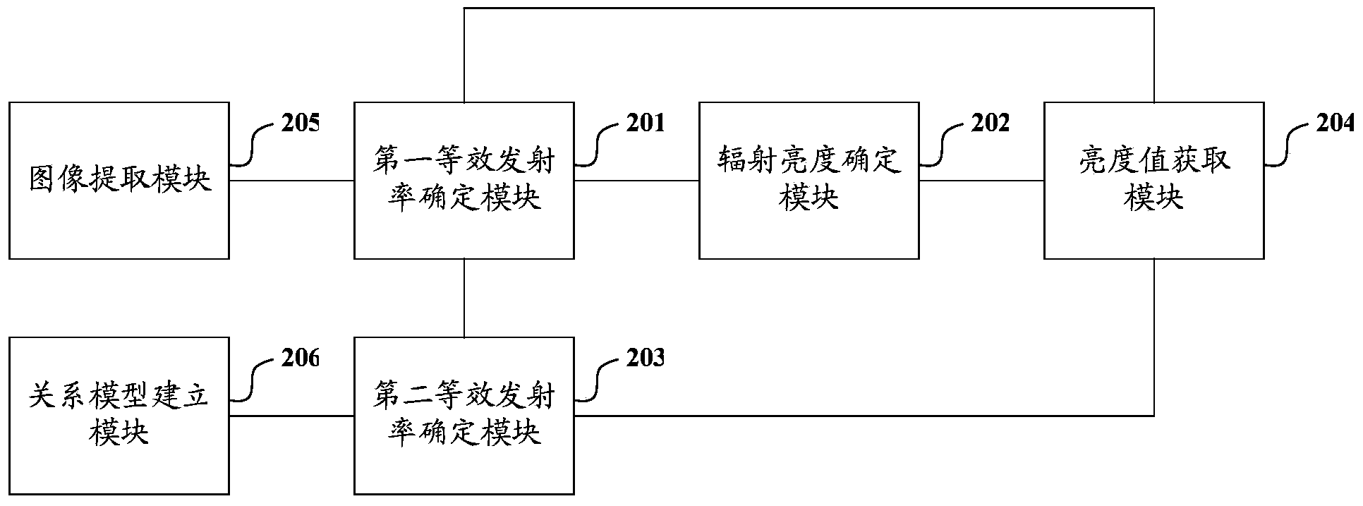
The invention discloses an image generating method based on infrared remote sensing data. The method comprises the steps that as for each picture element of an image of an actually measured infrared band, according to the brightness value of the picture element, the temperature of a ground object corresponding to the picture element is determined, and the equivalent emissivity of the ground object in the actually measured infrared band is determined; according to the temperature of the ground object, the radiation brightness of the ground object in a target infrared band is determined; according to the equivalent emissivity of the ground object in the actually measured infrared band, and a pre-built relation model of mapping relations of the equivalent emissivities of all the infrared bands, the equivalent emissivity of the ground object in the target infrared band is determined; the brightness value of the corresponding picture element in the image of the target infrared band is obtained by multiplying the radiation brightness of the ground object in the target infrared band by the equivalent emissivity of the ground object in the target infrared band. By applying the image generating method, utilization efficiency of image data of an existing infrared band can be improved, and cost is low.

Description

technical field [0001] The invention relates to aerospace remote sensing technology, in particular to an image generation method and system based on infrared remote sensing data. Background technique [0002] At present, the commonly used remote sensing image data are mainly provided by the TM (Thematic Mapper, thematic mapper) carried by Landste of the United States, and the HRV (High Resolution Visible, high-resolution visible light) carried by the French SPOT (satellite positioning and tracking, satellite positioning and tracking) satellite. ) sensor, MODIS (Moderate Resolution Imaging Spectrometer) carried by Tylenol Terra satellite, and AVHRR (Advanced Very High Resolution Radiometer) carried by NOAA (National Oceanic and Atmospheric Administration) satellite Type very high resolution radiometer), and the infrared scanner carried by my country's Fengyun series satellites. [0003] Among them, TM can shoot infrared remote sensing images in 4 bands, the spectral ranges are...

Claims


Application Information

Patent Timeline
IPC IPC(8): G06T1/00
Inventor 李霞王俊张文娟高连如
Owner BEIJING INST OF ENVIRONMENTAL FEATURES
Why Eureka
Try Eureka