Method for automatically extracting road information in vehicle-mounted laser scanning point cloud

A technology for vehicle-mounted laser scanning and road information, which is applied in the field of automatic extraction of road information from vehicle-mounted laser scanning point clouds, and can solve the problems of not considering road surface roughness, large amount of calculation, and reduced data accuracy and resolution.

Active Publication Date: 2014-05-07
QINGDAO XIUSHAN MOBILE SURVEYING CO LTD
View PDF3 Cites 46 Cited by
  • Summary
  • Abstract
  • Description
  • Claims
  • Application Information

AI Technical Summary

Problems solved by technology

The vehicle-mounted mobile laser measurement system can quickly obtain massive point cloud data on the road and both sides without affecting traffic conditions, but how to quickly and automatically extract road information from it is still a difficulty
[0003] In the process of realizing the present invention, the inventor found that the existing methods have the following deficiencies: 1) The effective information recorded by the on-board measurement system has not been mined and applied, such as the laser scanning angle; 2) Based on the grid data processing method in the point cloud grid 3) The classification method based on the point cloud distribution characteri

Method used


Image

  • Method for automatically extracting road information in vehicle-mounted laser scanning point cloud
  • Method for automatically extracting road information in vehicle-mounted laser scanning point cloud
  • Method for automatically extracting road information in vehicle-mounted laser scanning point cloud

Examples


Embodiment Construction

[0049] Below in conjunction with accompanying drawing and specific embodiment the present invention is described in further detail:

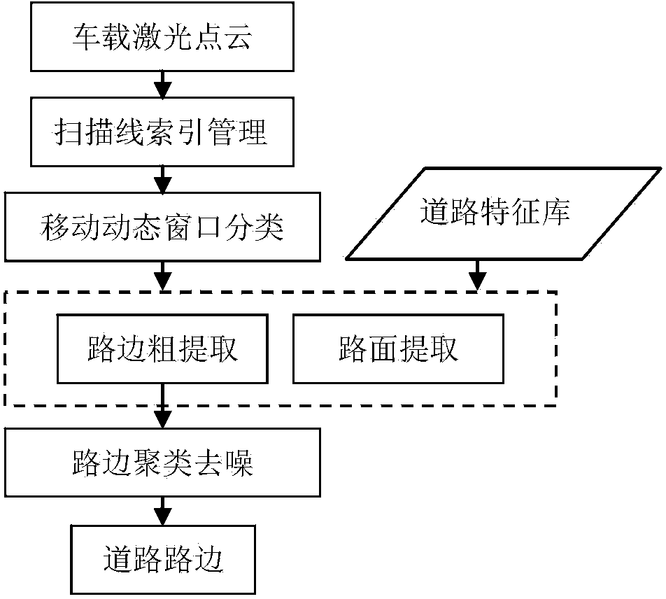
[0050] combine figure 1 As shown, a method for automatic extraction of road information in a vehicle-mounted laser scanning point cloud includes the following steps:

[0051] a. According to the driving track, laser point scanning angle and scanning time information recorded by the vehicle system, each scanning line is extracted from the discrete point cloud, and a half-scanning line index suitable for data processing is established; specifically, the following sub-steps are included:

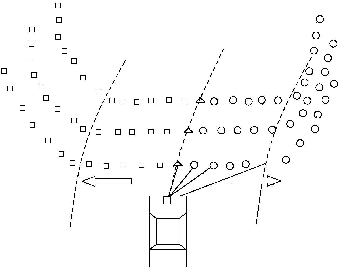
[0052] a1. Extract information such as driving trajectory, laser point scanning angle and scanning time during the entire data collection process recorded by the on-board system, perform a series of coordinate transformations on the point cloud data, and convert them into plane coordinates in the corresponding coordinate system. The time difference or angle diff...


PUM


Abstract

The invention discloses a method for automatically extracting road information in a vehicle-mounted laser scanning point cloud. The method for automatically extracting the road information in the vehicle-mounted laser scanning point cloud comprises the steps that all scanning lines are extracted from the discrete point cloud according to the information, such as the traveling track, the laser point scanning angle and the scanning time, which is recorded by a vehicle-mounted system, and a half scanning line index suitable for data processing is established; the spatial relation between two adjacent points is analyzed, laser point generation clustering is conducted, and dynamic window point sets which can describe the type characteristics of certain types of ground objects are generated; the main geometrical characteristic factors, comprising elevation difference factors and horizontal projection distance factors, of the different ground object window point sets are analyzed; window starting point types are judged according to the main geometrical characteristic factors of the window point sets, movement type dynamic window classification is conducted from a central angle point to the two sides according to the half scanning line index until a non-road-surface point is found; clustering and denoising are conducted on roadside points according to the distribution relation of bottom points of roadside stones and by the adoption of the principle of consistency between the scanning angle and the distance.

Description

technical field [0001] The invention belongs to the technical field of vehicle-mounted laser scanning point cloud data processing, and in particular relates to a method for automatically extracting road information from a vehicle-mounted laser scanning point cloud. Background technique [0002] High-precision, accurate and up-to-date urban road information plays an important role in road maintenance, traffic management and urban planning. At present, basic road information is mainly obtained through traditional manual measurement methods. The update cycle is long and difficult, which can no longer meet the data needs of urban construction and management. As an advanced measurement method, the vehicle-mounted mobile laser measurement system has the characteristics of fast, non-contact with the measurement object, real-time, dynamic, active, high density and high precision. The vehicle-mounted mobile laser measurement system can quickly obtain massive point cloud data on the ...

Claims


Application Information

Patent Timeline
IPC IPC(8): G06K9/46
Inventor 卢秀山田茂义刘如飞吴玮许君一王冬石波景冬
Owner QINGDAO XIUSHAN MOBILE SURVEYING CO LTD
Why Eureka
Try Eureka