Robust remote sensing image feature point pair extraction method for nonlinear radiation distortion
A remote sensing image and feature point pairing technology, applied in the field of remote sensing image processing, can solve the problems of low accuracy of satellite uncontrolled positioning and difficulty in fusion of heterogeneous information.
- Summary
- Abstract
- Description
- Claims
- Application Information
AI Technical Summary
Problems solved by technology
Method used
Image
Examples
Embodiment Construction
[0070] In order to better understand the contents of the present invention, an example is given here.
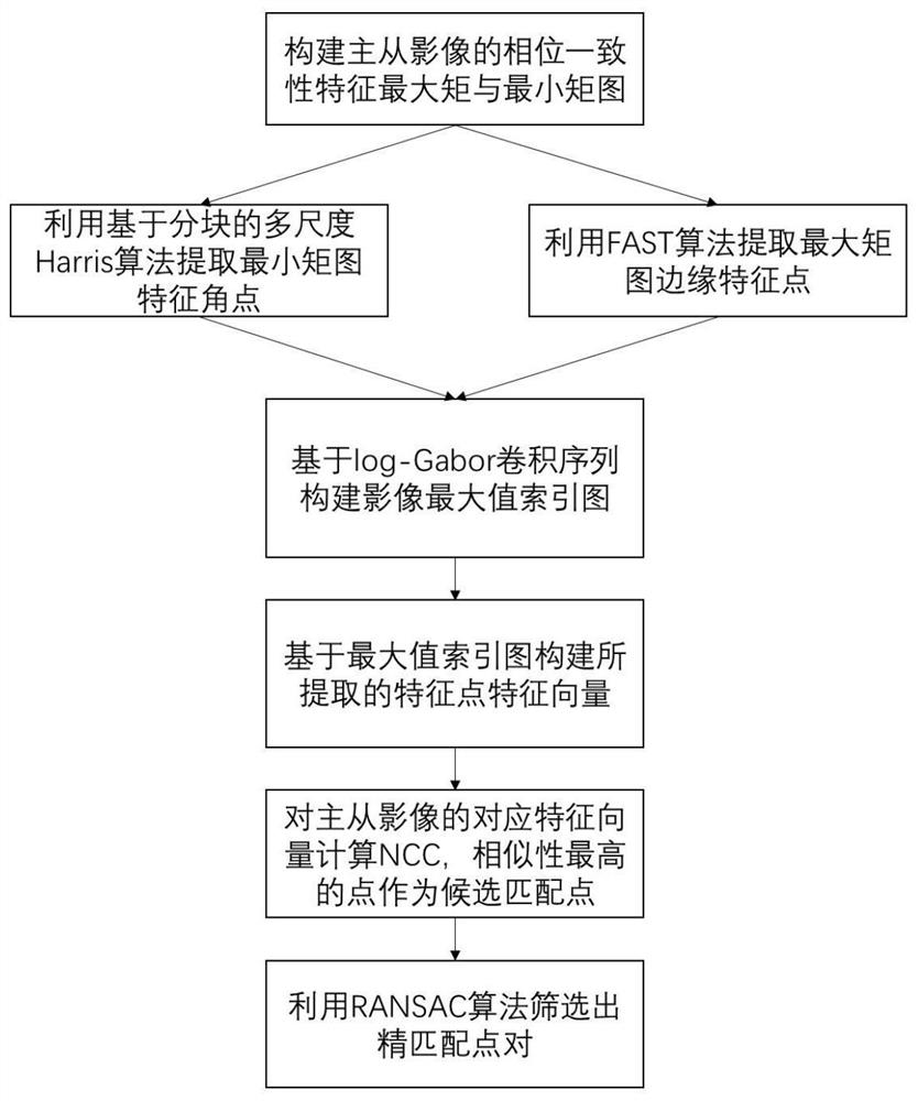
[0071] figure 1 It is a flow chart of the steps of the method for extracting accurate and robust feature points from multi-modal remote sensing images according to an embodiment of the present invention, as shown in figure 1 As shown, this embodiment discloses a robust remote sensing image feature point pair extraction method for nonlinear radiation distortion, and its specific steps are as follows:
[0072] S1. Perform image preprocessing on the two acquired multimodal remote sensing images, including:
[0073] S11, judging whether the acquired multi-modal remote sensing image is full-color black-and-white, if yes, transfer to S12, otherwise weighting the multi-modal remote sensing image into a black-and-white image;
[0074] S12, setting one image in the multimodal remote sensing image as the master image, and the other image as the slave image;
[0075] S13, respective...
PUM
 Abstract
Description
Claims
Application Information
 - R&D
- Intellectual Property
- Life Sciences
- Materials
- Tech Scout
- Unparalleled Data Quality
- Higher Quality Content
- 60% Fewer Hallucinations
Browse by: Latest US Patents, China's latest patents, Technical Efficacy Thesaurus, Application Domain, Technology Topic, Popular Technical Reports.
© 2025 PatSnap. All rights reserved.Legal|Privacy policy|Modern Slavery Act Transparency Statement|Sitemap|About US| Contact US: help@patsnap.com


