Urban impervious layer rate information extraction method based on multi-source remote sensing data

A technology of remote sensing data and extraction methods, which is applied in the directions of instruments, calculations, character and pattern recognition, etc., and can solve the problems of small number of bands, adverse effects of extraction accuracy, and insufficient fineness of results

Active Publication Date: 2014-05-28
WUHAN UNIV
View PDF1 Cites 24 Cited by
  • Summary
  • Abstract
  • Description
  • Claims
  • Application Information

AI Technical Summary

Problems solved by technology

[0007] The first type of pixel-based extraction methods are susceptible to the spectral confusion of ground objects. In recent years, the development of high-resolution remote sensing technology has made it possible to extract impermeable layers with high precision in local areas. However, due to the small number of bands, ground objects The problem of spectral confusion still exists. At the same time, the shadow of tall buildings in the image will also adversely affect the extraction accuracy; the second type of mixed pixel decomposition model is based on the assumption that there is no cross-reflection between the various components of the surface, which is not suitable for the non-existent surface. The actual situation of Lambertianity, and the accuracy of pixel decomposition largely depends on the accuracy of endmember selection, so this method has certain instability; the third type of indirect extraction metho

Method used


Image

  • Urban impervious layer rate information extraction method based on multi-source remote sensing data
  • Urban impervious layer rate information extraction method based on multi-source remote sensing data
  • Urban impervious layer rate information extraction method based on multi-source remote sensing data

Examples


Embodiment Construction

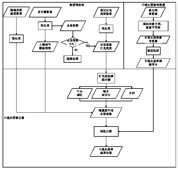
[0042] During specific implementation, the process provided by the technical solution of the present invention can be automatically run by those skilled in the art using computer software technology. In order to better understand the technical solution of the present invention, the present invention will be further described in detail below in conjunction with the accompanying drawings and embodiments.

[0043] see figure 1 , the embodiment of the present invention includes the following steps:

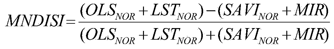
[0044] Step a, first crop the acquired night light brightness image and re-project it into the WGS84 coordinate system. According to the night light brightness image, the light brightness of each pixel is obtained and recorded as OLS; then the normalized light brightness is calculated with the administrative area (such as district / county) as the regional unit, and the landscape area is segmented on the urban surface based on the threshold segmentation method. The normalized light br...


PUM


Abstract

The invention discloses an urban impervious layer information extraction method based on multi-source remote sensing data. The method comprises the following steps: calculating normalized light brightness and performing area type segmentation on the urban surface based on a threshold segmentation method according to a night light brightness image; constructing enhanced normalized impervious layer indexes by utilizing the light brightness, the land surface temperature and normalized soil regulation vegetation indexes; and performing extraction operation on the impervious layer by constructing a linear quantitative relation between the enhanced normalized impervious layer indexes MNDISI in each type segmentation area and the impervious layer rate. The advantages of the multi-source remote sensing data are well combined, an adverse effect of spectral confusion on an estimation result of the impervious layer rate is effectively inhibited, and a novel way is provided for urban land utilization and environmental change monitoring.

Description

technical field [0001] The invention belongs to the field of information extraction of remote sensing image data, and relates to a method for extracting urban impermeable layer information based on multi-source remote sensing data. Background technique [0002] With the acceleration of economic development and urbanization, various production and construction activities of human beings are increasingly changing the natural environment and land cover types in and around cities. The impermeable layer is defined as an impermeable non-natural ground surface composed of various artificial buildings, roads, airports, etc. The impermeable layer rate refers to the percentage of the impermeable layer in a unit area. The large-scale impermeable layer in the city will affect the heat absorption and release of the underlying surface under solar radiation, causing the "heat island" phenomenon. Around cities, expansion of impervious layers inhibits vegetation response to atmospheric CO ...

Claims


Application Information

Patent Timeline
IPC IPC(8): G06K9/46
Inventor 邵振峰刘冲
Owner WUHAN UNIV
Why Eureka
Try Eureka