Wireless sensor network search-and-rescue target location method based on maritime environment self-adaptation RSST distance measurement

A wireless sensor network and target positioning technology, applied in the field of wireless sensor network search and rescue target positioning algorithm, can solve the problems of low RSSI ranging and positioning accuracy

Active Publication Date: 2014-06-25
SHANGHAI MARITIME UNIVERSITY
View PDF2 Cites 32 Cited by
  • Summary
  • Abstract
  • Description
  • Claims
  • Application Information

AI Technical Summary

Problems solved by technology

[0005] The purpose of the present invention is to provide a positioning method based on the maritime search and rescue environment adaptive RSSI ranging algorithm, in order to solve the problem of low RSSI ranging and positioning accuracy due to the complex dynamic environment at sea

Method used


Image

  • Wireless sensor network search-and-rescue target location method based on maritime environment self-adaptation RSST distance measurement
  • Wireless sensor network search-and-rescue target location method based on maritime environment self-adaptation RSST distance measurement
  • Wireless sensor network search-and-rescue target location method based on maritime environment self-adaptation RSST distance measurement

Examples


Embodiment Construction

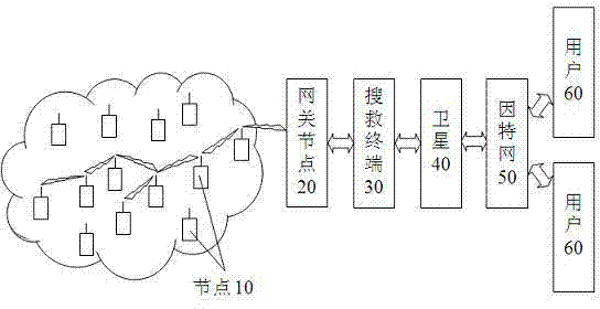
[0049] Such as figure 1 As shown, the wireless sensor network suitable for the search and rescue target positioning method described in the present invention includes a large number of nodes 10 on the sea, and these nodes 10 can be various types of survival equipment pre-installed on ships, survival craft, lifejackets and life buoys, etc. The sensor nodes, these nodes 10 are artificially turned on or activated when encountering seawater when a shipwreck occurs, and can self-organize into a wireless sensor network through the ZigBee protocol. Any node 10 can directly send information such as its own location to the gateway node 20, or forward it to the gateway node 20 through other nodes 10; these nodes 10 can also receive and forward information from the gateway node 20. The gateway node 20 can communicate bidirectionally with the search and rescue terminal 30, and the search and rescue terminal 30 can access the Internet 50 through means such as satellite 40, so that users 60...


PUM


Abstract

The invention provides a wireless sensor network search-and-rescue target location method based on maritime environment self-adaptation RSST distance measurement. Wireless sensor network application and maritime search and rescue are combined to change the situation that maritime search-and-rescue targets can only wait for rescue. A easily operated and arranged RSST distance measurement algorithm which is not required to be supported by additional hardware is selected, mobile anchor nodes are introduced based on shielding models, required parameters are calculated by utilizing mutual coordination of the anchor nodes, and optimized paths loss models can meet maritime search and rescue application environments at the moment. Gaussian filter are utilized to perform filtering on measured RSST number values, accordingly accurate RSST number values are obtained, the optimized paths loss models are substituted to obtain accurate distances between the anchor nodes ad unknown nodes. Finally, maritime search-and-rescue targets are positioned by utilizing a wireless sensor network triangular centroid algorithm, and target location accuracy and search-and-rescue success rate are improved.

Description

technical field [0001] The invention relates to a maritime search and rescue positioning method, in particular to a wireless sensor network search and rescue target positioning algorithm based on adaptive RSSI ranging in the marine environment. Background technique [0002] With the continuous development of the global shipping industry, the number of ships at sea continues to increase, and the safety of ships has been increasingly challenged. Shipwrecks and accidents occur frequently. Once an accident occurs, the most important thing is to search and rescue people floating at sea to protect their lives and properties. Safety. The traditional search and rescue method is mainly to dispatch a large number of search and rescue ships, helicopters, etc. to conduct a blanket search, which not only wastes a lot of manpower and material resources, but also has poor search and rescue results. Although technologies such as radar and machine vision are currently applied to maritime se...

Claims


Application Information

Patent Timeline
Patent Type & Authority Applications(China)
IPC IPC(8): H04W64/00H04W84/18
Inventor 吴华锋杨磊
Owner SHANGHAI MARITIME UNIVERSITY
Why Eureka
Try Eureka