
A Remote Sensing Identification Method for Surface Water System Around Coal Mine

A remote sensing recognition and surface technology, applied in character and pattern recognition, instruments, computer parts, etc., can solve problems such as uncommon use, complex methods, changes in spectral characteristics, etc. Effect

Active Publication Date: 2017-09-19
青岛星科瑞升信息科技有限公司
View PDF2 Cites 0 Cited by
  • Summary
  • Abstract
  • Description
  • Claims
  • Application Information

AI Technical Summary

Problems solved by technology

However, around the coal mining area, the terrain is relatively complex, and the water body has a significant change in the spectral characteristics due to the pollution of dust and wastewater generated by mining mining, and the difference between the water body and the surrounding land features is reduced.
Simply extracting the water body through the threshold method, the effect is not ideal, and the confusion between the water body and the shadow is more serious
The threshold-based water index and spectral relationship method, after many attempts, can remove some shadows to a certain extent, but the choice of the threshold is the key. It will remove some water bodies with similar spectral characteristics while removing shadows. Additional Design how to realize the re-extraction of lost water bodies, the method is complicated and not universal, which is not conducive to the fine extraction of water sources and subsequent change monitoring

Method used


Image

  • A Remote Sensing Identification Method for Surface Water System Around Coal Mine

Examples


Embodiment Construction

[0019] The present invention provides a remote sensing identification method for surface water systems around coal mines. In order to make the purpose, technical solutions and effects of the present invention clearer and clearer, the present invention will be further described in detail below. It should be understood that the specific embodiments described here are only used to explain the present invention, not to limit the present invention.

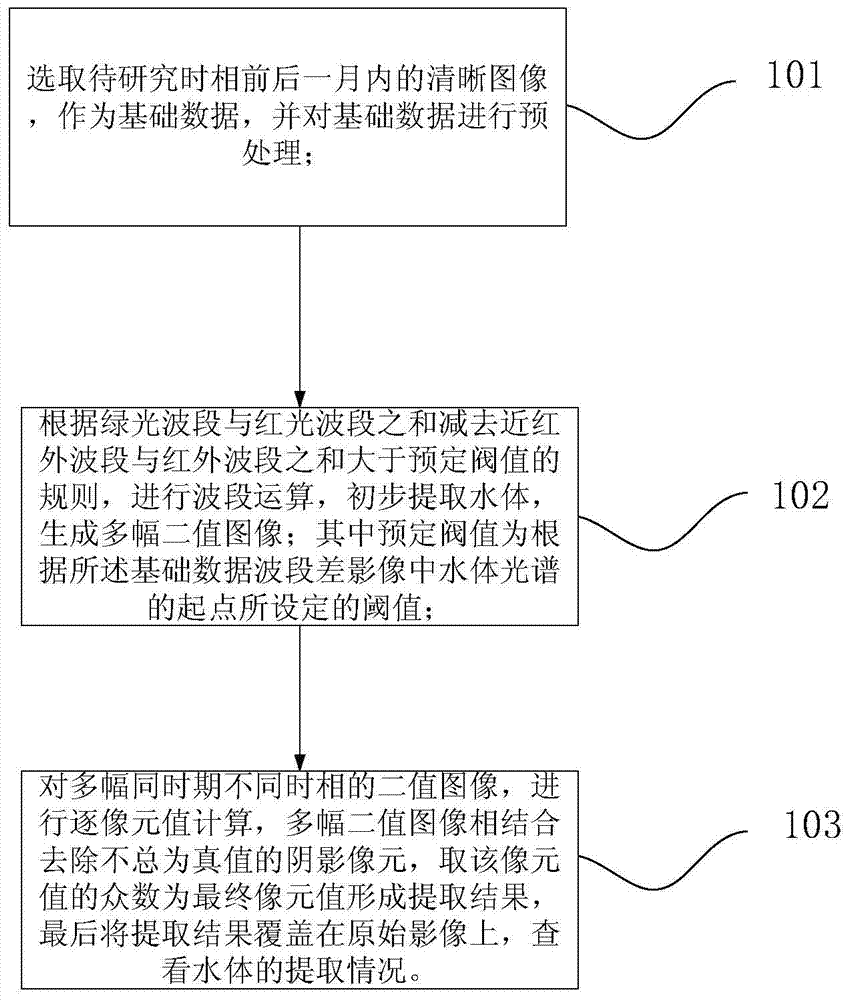
[0020] The invention provides a remote sensing identification method for the surface water system around the coal mine, such as figure 1 As shown, it includes the following steps:

[0021] Step 101: Select clear images within one month before and after the time phase to be studied as the data source, and preprocess the data source;

[0022] Step 102: According to the rule that the sum of the green light band and the red light band minus the sum of the near-infrared band and the infrared band is greater than the predetermined threshold...


PUM


Abstract

The invention discloses a remote sensing identification method for surface water systems around coal mines, which comprises the following steps: selecting a clear image within one month before and after the time phase to be studied as a data source, and preprocessing the data; The sum of the red band minus the sum of the near-infrared band and the infrared band is greater than the predetermined threshold, and the band calculation is performed to initially extract the water body and generate multiple binary images; the predetermined threshold value is based on the water body spectrum in the band difference image The threshold set by the starting point; multiple binary images of the same period and different time phases are combined to perform pixel-by-pixel calculations, and the mode of the pixel value is taken as the final pixel value to remove shadows that are not always true The pixel forms the extraction result, and finally the extraction result is overlaid on the original image to check the extraction situation of the water body. The public water body part of the multi-temporal image is retained, which can effectively remove shadows and improve the accuracy of water body recognition.

Description

technical field [0001] The invention relates to a method for extracting water bodies around coal mines by using satellite remote sensing images, in particular to a remote sensing identification method for surface water systems around coal mines. Background technique [0002] Water resources are an important restrictive factor for social and economic development and ecological environment stability. How to quickly and accurately determine the distribution of water resources has attracted more and more attention. Mining activities around the coal mining area have caused serious changes to the underground environment, affecting the surface runoff and thus affecting the surrounding ecological environment. Therefore, it is of great significance to accurately extract the surface water system around the coal mining area to accurately evaluate the impact of mining activities on the surface ecology. Due to the characteristics of large-area synchronous observation, real-time, and eco...

Claims


Application Information

Patent Timeline
Patent Type & Authority Patents(China)
IPC IPC(8): G06K9/00
Inventor 孙林翟秋萍
Owner 青岛星科瑞升信息科技有限公司
Learn More