Spatio-temporal dynamic analysis method of soil erosion in meso-scale watershed based on GIS

A soil erosion, space-time dynamic technology, applied in soil material testing, material inspection products, etc., can solve the problems of not being able to provide references for the configuration of water and soil conservation measures, and not being able to reflect differences in water and soil loss

Inactive Publication Date: 2014-07-23
NORTHWEST A & F UNIV
View PDF2 Cites 30 Cited by
  • Summary
  • Abstract
  • Description
  • Claims
  • Application Information

AI Technical Summary

Problems solved by technology

[0004] In the existing technology, there is a model that fully considers regional differences. It models the whole country in different regions and considers the impact of runoff, rainfall, and soil and water conservation measures on erosion. However, this model is still a lumped model and cannot reflect the water and soil in

Method used


Image

  • Spatio-temporal dynamic analysis method of soil erosion in meso-scale watershed based on GIS
  • Spatio-temporal dynamic analysis method of soil erosion in meso-scale watershed based on GIS
  • Spatio-temporal dynamic analysis method of soil erosion in meso-scale watershed based on GIS

Examples


Embodiment Construction

[0084] The above and other technical features and advantages of the present invention will be described in more detail below in conjunction with the accompanying drawings.

[0085] The present invention is based on the GIS-based temporal and spatial dynamic analysis method for soil erosion in medium-scale watersheds, and realizes the quantitative evaluation of soil erosion in large and medium watersheds based on a distributed empirical model.

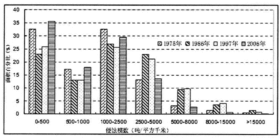
[0086] The experimental data of the present invention is based on the data and calculation results of the Gushanchuan River Basin, analyzes the temporal and spatial variation characteristics of soil erosion, and explores the reasons for the spatial variation characteristics.

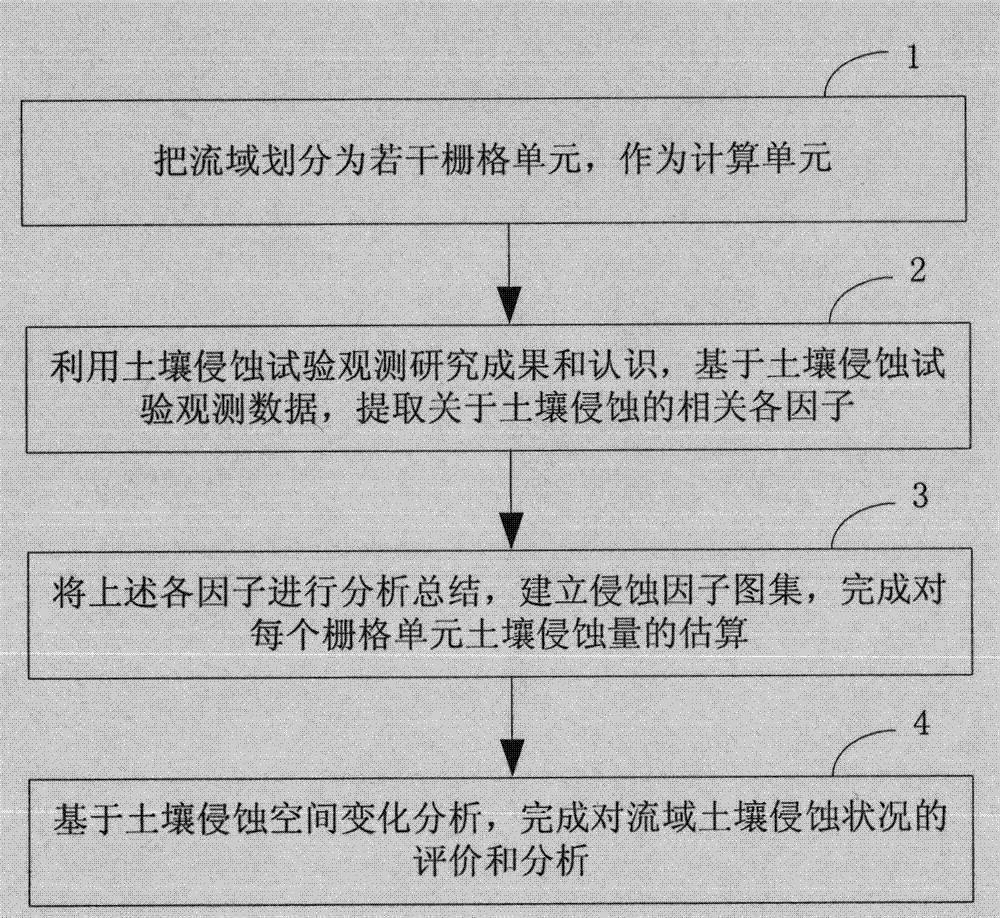
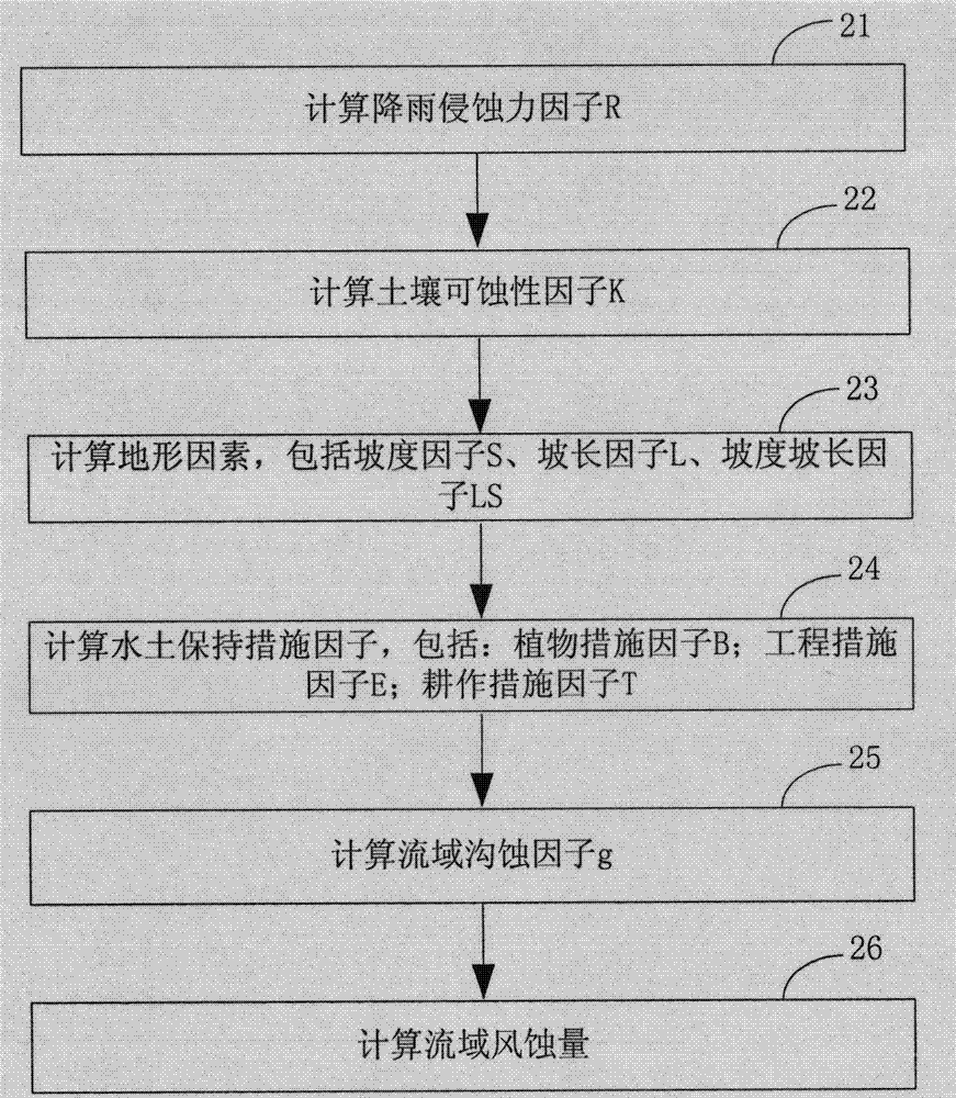
[0087] The calculation process of this model is:

[0088] Step 1, divide the watershed into several grid units;

[0089] Step 2, using the soil erosion test observation research results and understanding, based on the soil erosion test observation data, extractin...


PUM


Abstract

The invention relates to a spatio-temporal dynamic analysis method of soil erosion in meso-scale watershed based on GIS. The spatio-temporal dynamic analysis method comprises following specific steps: the meso-scale watershed is divided into a plurality of grid cells as calculation units; soil erosion experiments are used for measuring research results and knowledge, and a plurality of factors related to soil erosion are extracted based on soil erosion experiment observation data; the plurality of factors are subjected to analysis and summary, an erosion factor collective drawing is established, and estimation on soil erosion amount of each grid cell is finished; and evaluation and analysis on watershed soil erosion states are finished based on soil erosion space variation analysis. According to the spatio-temporal dynamic analysis method, space nonuniformity of soil erosion and the factors of soil erosion is taken into consideration, so that a slope surface model is combined with GIS, and calculation on each unit is finished; and substance transmission and migration are taken into consideration appropriately, distribution calculation on soil loss is finished, and a soil erosion figure is obtained.

Description

technical field [0001] The invention relates to the field of regional soil erosion, in particular to a GIS-based method for time-space dynamic analysis of mesoscale watershed soil erosion. Background technique [0002] Soil erosion is a multi-temporal and spatial-scale process, and the distribution of soil erosion has obvious temporal and spatial variation characteristics. To scientifically prevent and control soil erosion requires the study of its temporal and spatial variation. The soil erosion model includes the empirical model, that is, starting from the basic causes of erosion and sediment production, based on actual observation data, using the method of mathematical statistical analysis, the empirical relationship between the erosion and sediment production of slopes, watersheds or regions and their main influencing factors is established . [0003] At present, the USLE model has a wide range of applications. It can estimate the soil loss rate under different soils, s...

Claims


Application Information

Patent Timeline
IPC IPC(8): G01N33/24
Inventor 张宏鸣杨勤科李书琴韩文霆黄玉祥王美丽刘晴蕊程琳
Owner NORTHWEST A & F UNIV
Why Eureka
Try Eureka