Navigation radar image sea surface wind direction inversion method based on wave number energy spectrum

A technology of navigation radar and wavenumber energy, which is applied in the field of inversion of ocean surface wind direction, can solve problems such as the inability to automatically find reduced image resolution, the impossibility of practical application of the algorithm, and the instability of wind direction inversion error, etc.

Active Publication Date: 2014-07-23
哈尔滨哈船导航技术有限公司
View PDF7 Cites 21 Cited by
  • Summary
  • Abstract
  • Description
  • Claims
  • Application Information

AI Technical Summary

Problems solved by technology

However, there are still some insurmountable defects: For airborne remote sensing technology, aircraft navigation is greatly affected by weather, and it cannot work under severe marine weather conditions
However, the scale of the wind stripes is between 100 and 500. It

Method used


Image

  • Navigation radar image sea surface wind direction inversion method based on wave number energy spectrum
  • Navigation radar image sea surface wind direction inversion method based on wave number energy spectrum
  • Navigation radar image sea surface wind direction inversion method based on wave number energy spectrum

Examples


Embodiment Construction

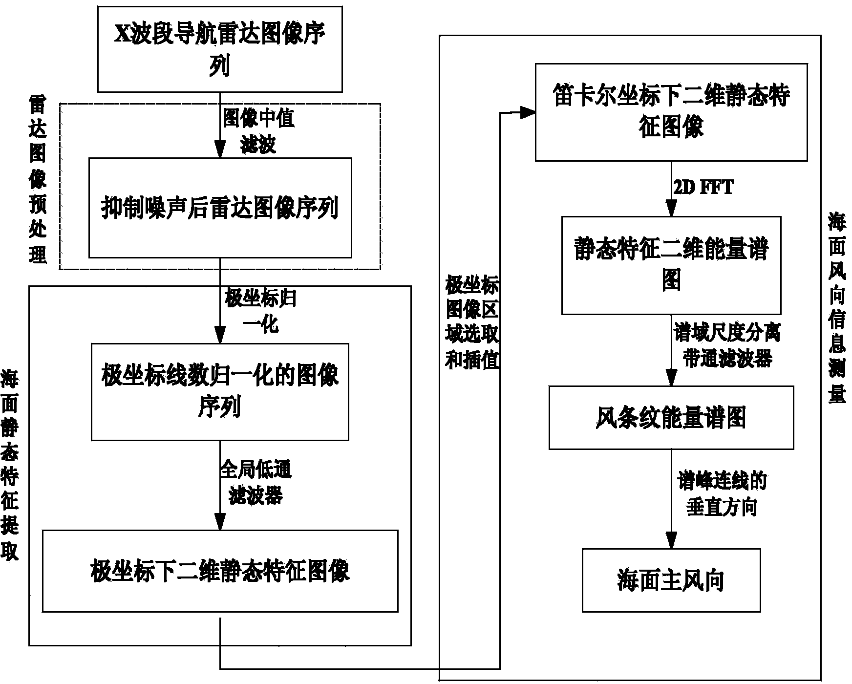
[0073] The present invention will be further described below in conjunction with the accompanying drawings.

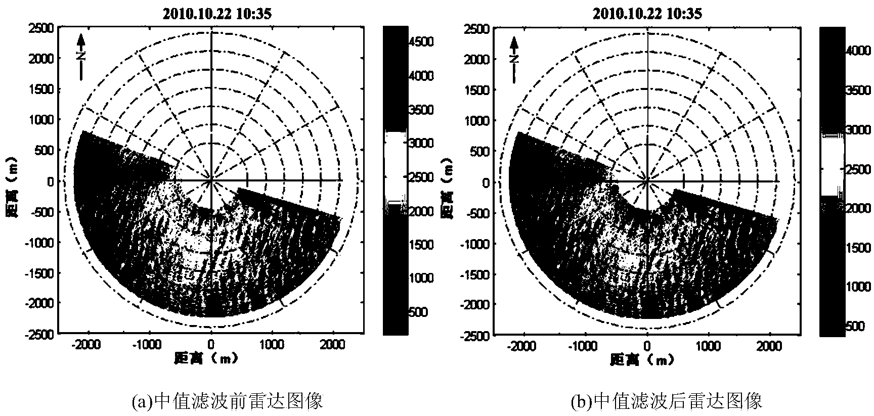
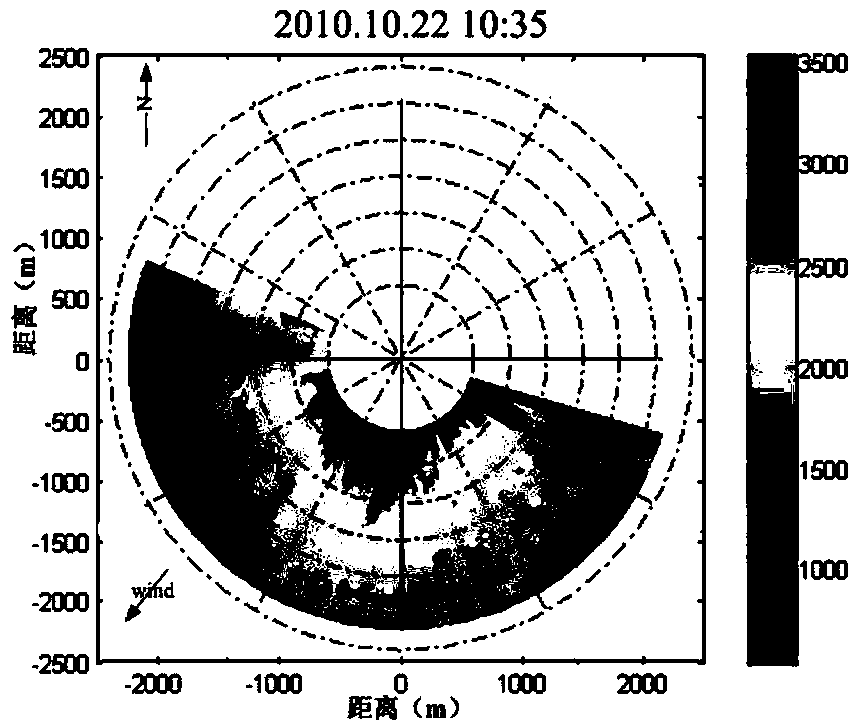
[0074]The invention discloses a method for retrieving sea surface wind direction based on navigation radar image of wave number energy spectrum, and belongs to the field of retrieving sea surface wind direction by means of remote sensing. The measurement method includes three parts: radar image preprocessing, sea surface static feature extraction, and sea surface wind direction information inversion. By establishing a global low-pass filter, the sea surface static feature signal in the radar image is extracted to provide a basis for subsequent sea surface wind field research. Foundation. The energy spectrum of two-dimensional static features is obtained by two-dimensional discrete fast Fourier transform. Combined with the scale of wind streaks of 100-500m, a wave number energy spectrum band-pass filter is established to separate the energy spectrum of wind streaks. Acc...


PUM


Abstract

The invention belongs to the field of sea surface wind direction inversion through a remote sensing means, and particularly relates to a navigation radar image sea surface wind direction inversion method based on a wave number energy spectrum. The method comprises the steps of preprocessing a radar image, extracting sea surface static characteristics and inverting sea surface wind direction information. According to the navigation radar image sea surface wind direction inversion method based on the wave number energy spectrum, a space domain does not need to be reduced, the space domain can automatically adapt to wind stripes of different scales, the wind direction can be measured under different sea conditions, an error result is stable, and engineering availability is high. According to the navigation radar image sea surface wind direction inversion method based on the wave number energy spectrum, only the wind stripe energy spectrum is extracted through wave number energy spectrum wave number scale separation, the wind direction inversion precision is improved, and the interference of the noise of other scales is reduced.

Description

technical field [0001] The invention belongs to the field of retrieving the sea surface wind direction by means of remote sensing, and in particular relates to a method for retrieving the sea surface wind direction based on a navigation radar image of a wave number energy spectrum. Background technique [0002] Sea surface wind field is an important source of power at the sea-steam interface, which is of great significance to navigation operations and ocean dynamics research. Sea surface wind field information mainly includes two aspects of sea surface wind direction and sea surface wind speed, and the present invention is used to invert the information of sea surface wind direction. [0003] Traditional wind direction information acquisition methods are mainly divided into two categories: site-based on-site measurement and remote sensing measurement. [0004] Site-based on-site measurement mainly includes shore-based wind vane single-point measurement, buoys, observation s...

Claims


Application Information

Patent Timeline
IPC IPC(8): G01S13/95
CPCG01P13/02G01S7/412G01S13/95Y02A90/10
Inventor 卢志忠王慧邱海洋熊平吕杰戴云桃葛琪卫延波冯海玉孙铎
Owner 哈尔滨哈船导航技术有限公司
Why Eureka
Try Eureka