Lane line detection and GIS map information development-based vision navigation method

Active Publication Date: 2014-07-30
长沙谱蓝网络科技有限公司
View PDF3 Cites 107 Cited by
  • Summary
  • Abstract
  • Description
  • Claims
  • Application Information

AI Technical Summary

Problems solved by technology

The current lane line detection system can meet the requirements in basic scenarios, but vision-based methods will be affected by many factors, such as road obstacles, unclear road markings, weather effects, and lighting changes.
These factors will lead to false detection and missed detection in the system, and the system lacks the evaluation of the verification and reliability of the detection results

Method used


Image

  • Lane line detection and GIS map information development-based vision navigation method
  • Lane line detection and GIS map information development-based vision navigation method
  • Lane line detection and GIS map information development-based vision navigation method

Examples


Embodiment Construction

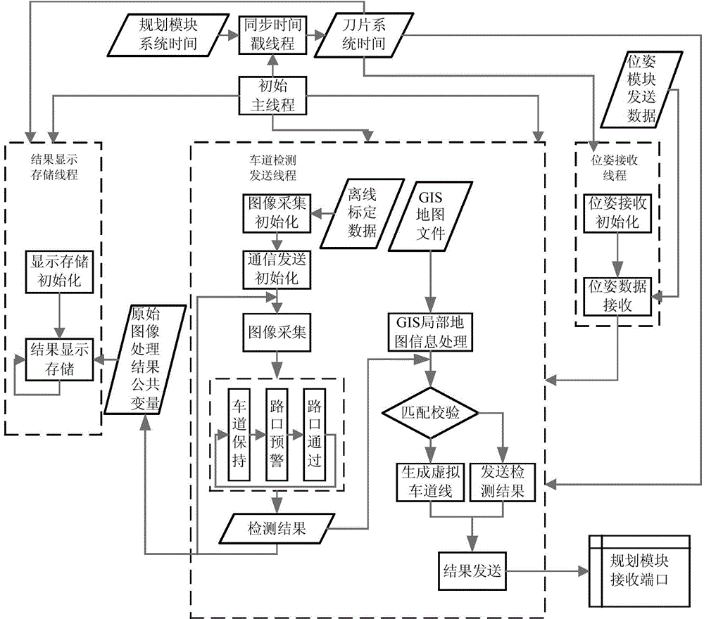
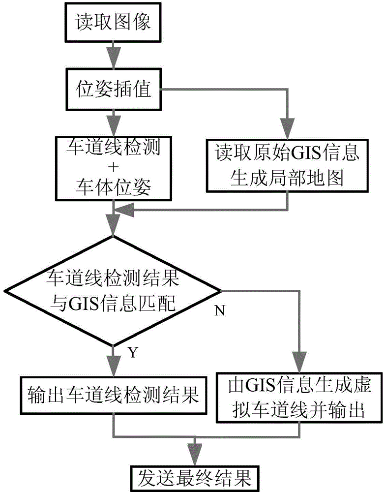
[0035] The present invention will be described in detail below in conjunction with the accompanying drawings.

[0036] see figure 1 as well as figure 2 , the method mainly includes the following steps:

[0037] 1) Collect and preprocess GIS map information in advance;

[0038] 2) Collect images in real time and perform lane line detection;

[0039] 3) Real-time generation of GIS local maps;

[0040] 4) The lane line detection result is matched with the GIS local map for verification;

[0041] 5) Generate a highly reliable lane line result based on the matching result.

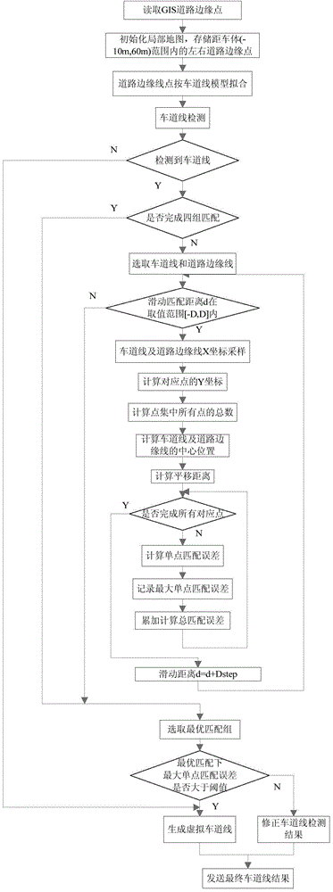
[0042] The GIS map road edge information to be used in the algorithm is realized through on-the-spot GPS data collection and map marking. During calibration, the left edge of the road and the right edge of the road are marked respectively, and the marked road is one-way, and each road section is arranged in the order of the predetermined driving route. The data form of the map information is given in th...


PUM


Abstract

The invention discloses a lane line detection and GIS map information development-based vision navigation method. The method comprises the following steps: acquiring GIS map information, preprocessing, carrying out real-time image acquisition and lane line detection to generate a GIS local map in real-time, carrying out coupling verification on a track line detection result and the GIS local map through an ICP algorithm, and generating a high-credibility track line result according to the coupling result. The method can realize the credibility evaluation of the lane line detection through a geographic information system, corrects when false detection or missing inspection appears, expands the application range of the lane detection algorithm, and also can improve the map positioning precision through visual perception information, so the performances of a vision navigation system in a whole intelligent driving and aided driving system are improved, thereby the system can adapt to more complex environments.

Description

technical field [0001] The invention belongs to the field of intelligent control of unmanned driving, and relates to a visual navigation method for vehicle intelligent driving, especially a visual navigation method developed based on the combination of lane line detection and geographic information system (Geographic Information System, GIS) map information, It is used to evaluate and verify the reliability of traditional lane line detection results in real time, and improve the accuracy of intelligent driving visual navigation. Background technique [0002] Visual navigation is a key technical step in intelligent driving and assisted driving. It extracts useful information from the environment by processing visual data (generally image data), and provides a reliable basis for driving decisions. Lane line detection is one of the important aspects. Generally, the front-view camera is used to collect images for image processing to obtain information on road conditions, includi...

Claims


Application Information

Patent Timeline
Patent Type & Authority Applications(China)
IPC IPC(8): G01C21/00
CPCG01C21/30G01C21/3658
Inventor 杜少毅沈雅清崔迪潇宋晔薛建儒
Owner 长沙谱蓝网络科技有限公司
Why Eureka
Try Eureka