Land surface temperature (LST) inversion method based on HJ-1B IRS satellite data

A technology of HJ-1BIRS and satellite data, applied in radiation pyrometry, measuring devices, instruments, etc., can solve the problems of low level of sensor temperature control technology, gaps, restrictions and quantitative applications, etc., and achieve the expansion of quantitative application value and accuracy high effect

Active Publication Date: 2014-08-13
INST OF REMOTE SENSING & DIGITAL EARTH CHINESE ACADEMY OF SCI
View PDF3 Cites 12 Cited by
  • Summary
  • Abstract
  • Description
  • Claims
  • Application Information

AI Technical Summary

Problems solved by technology

However, due to the low level of temperature control technology of the sensor itself and the inaccurate absolute calibration coefficient, the LST inversion accuracy of HJ-1B IRS data is not high and unstable, which seriously restricts its quantitative application.
[0004] In order to improve the LST inversion accuracy of HJ-1B IRS data, domestic scientists have done a lot of valuable work. For on-satellite calibration, some scholars use the 31-channel data of the US TERRA satellite MODIS sensor in different phase...

Method used


Image

  • Land surface temperature (LST) inversion method based on HJ-1B IRS satellite data
  • Land surface temperature (LST) inversion method based on HJ-1B IRS satellite data
  • Land surface temperature (LST) inversion method based on HJ-1B IRS satellite data

Examples


Embodiment Construction

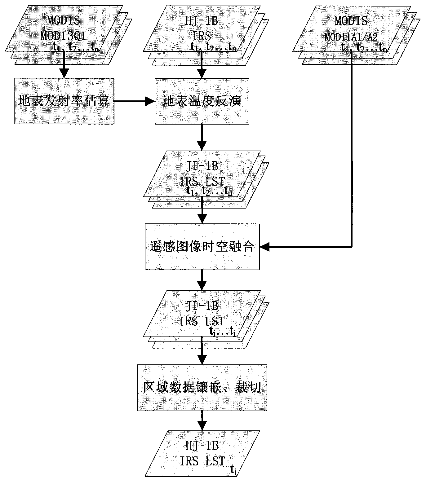
[0023] The implementation example of using the present invention to realize HJ-1B IRS satellite data inversion LST figure 1 Shown, it is described in conjunction with accompanying drawing now.

[0024] figure 1 The input data of the inversion process shown is the multi-view HJ-1B IRS satellite data in the same area. The IRS sensor of this data has 4 bands, and the fourth band with a wavelength of 10.5-12.5 μm can be used for LST inversion, and the spatial resolution The rate is 300 meters, the width is 720 kilometers, and the maximum field of view is 30°. The data acquisition time is different, which is t 1 , t 2 ,...t n The time is limited to within one month. Download the corresponding MODIS data according to the HJ-1B IRS satellite data, specifically the 16-day synthetic MOD13Q1 vegetation index product and the daily or 8-day synthetic MOD11A1 / A2 surface temperature product. Download MODIS data through the network, URL: http: / / reverb.echo.nasa.gov / reverb / .

[0025]...


PUM


Abstract

The invention provides a land surface temperature (LST) inversion technology based on domestic HJ-1B satellite IRS sensor data. The LST inversion method based on the HJ-1B IRS satellite data mainly comprises the following steps that the land surface emissivity (LSE) is inverted through a vegetation index product of a MODIS, the LST is inverted through a mono-window algorithm, LST data in different time phases are converted into a benchmark time phase through a sensing image time-space fusion technology, and inlaying and cutting of area data are carried out. The LST inversion method based on the HJ-1B IRS satellite data adopts the sensing image time-space fusion technology, improves the LST inversion accuracy of the HJ-1B IRS data through a foreign MODIS sensor high-accuracy LST product, and meanwhile achieves the purpose of producing large-area same-time-phase HJ-1B IRS LST products.

Description

technical field [0001] The invention relates to a method for retrieving LST based on HJ-1B IRS satellite data, which is a practical technical method for retrieving LST of surface temperature by using domestic HJ-1B satellite IRS sensor data, and can be applied in agriculture and environmental monitoring, etc. The field belongs to the field of satellite remote sensing technology. Background technique [0002] Land Surface Temperature (LST) is an important geophysical parameter. The technology of extracting Sea Surface Temperature (SST) from satellite remote sensing data is relatively mature and can achieve 1K accuracy on a global scale. Because the land surface is much more complex than the ocean surface, the accuracy of land surface temperature retrieval is low, and land surface temperature retrieval has become a scientific problem that needs to be solved urgently. [0003] With the development of remote sensing technology, geothermal infrared remote sensing plays an impor...

Claims


Application Information

Patent Timeline
IPC IPC(8): G01J5/00
Inventor 胡昌苗单小军李宏益唐亮赵理君郑柯
Owner INST OF REMOTE SENSING & DIGITAL EARTH CHINESE ACADEMY OF SCI
Why Eureka
Try Eureka