Multi-sensor data fusion aviation coil inertial navigation device

A data fusion, multi-sensor technology, used in navigation, measurement devices, ground navigation, etc., can solve the problems of accumulation, measurement value drift, not meeting the dynamic stability and robustness of the ZTEM aerial electromagnetic exploration system, and reduce weight. , Solve the effect of poor dynamic performance and convenient transportation

Inactive Publication Date: 2017-02-15
JILIN UNIV
View PDF2 Cites 0 Cited by
  • Summary
  • Abstract
  • Description
  • Claims
  • Application Information

AI Technical Summary

Problems solved by technology

Due to the use of a single or two sensors, there are inherent characteristics. With the external changes of time and temperature, the error will accumulate over time, and the measured value will drift. The accuracy can only be guaranteed in a short time, which does not meet ZTEM Requirements for Dynamic Stability and Robustness of Aeronautical Electromagnetic Surveying System

Method used


Image

  • Multi-sensor data fusion aviation coil inertial navigation device
  • Multi-sensor data fusion aviation coil inertial navigation device

Examples


Embodiment Construction

[0022] Below in conjunction with accompanying drawing and embodiment the present invention is described in further detail:

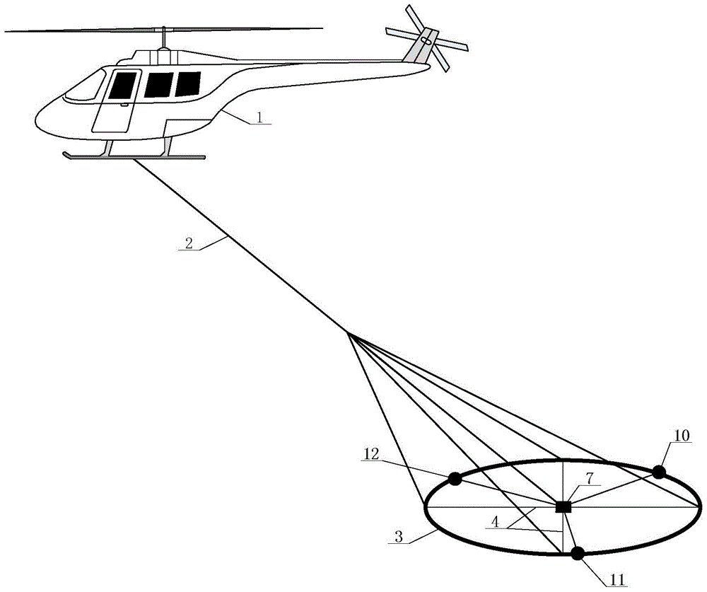
[0023] The aviation coil inertial navigation device with multi-sensor data fusion is that the upper end of the suspension rope 2 is tied to the bilge of the single-rotor unmanned helicopter 1, and the lower end of the suspension rope 2 is tied to the cross support 4 at equal angles, and the cross support 4 supports Z Component receiving coil 3, the first attitude sensor 10, the second attitude sensor 11 and the third attitude sensor 12 are equidistantly fixed on the Z component receiving coil 3, the attitude sensor 10, the attitude sensor 11 and the attitude sensor 12 communicate with each other through the signal transmission line 6 The attitude data recording system 7 fixed in the center of the cross-shaped bracket is connected to form.

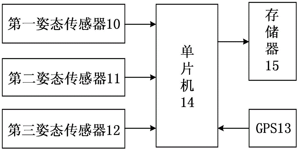
[0024] Attitude data collection system 7 is to be connected GPS13 and memory 15 respectively through single-chip mi...


PUM


Abstract

The invention relates to a multi-sensor data fused aviation coil inertial navigation device, wherein the upper end of a suspending rope is tied on the bottom of a single rotor unmanned helicopter, the lower end of the suspending rope is tied on a cross-shaped support in an equal angle, the cross-shaped support supports a Z-component receiving coil, and three altitude sensors are equidistantly fixed on the Z-component receiving coil and are connected with a posture data recording system through signal transmission lines; each posture sensor consists of an MEMS three-axis gyroscope, an MEMS three-axis accelerometer and an MEMS three-axis magnetoresistive sensor. According to the multi-sensor data fused aviation coil inertial navigation device, the measurement on an air posture deflection angle of an aviation coil is realized; the multi-sensor data fused aviation coil inertial navigation device has the characteristics of small size, quick response and low cost; in addition, after performing the data fusion processing, the influence on swinging posture of the aviation coil in the environment can be effectively reduced, and the corrected inversion magnetic field data can meet the precision requirement of a system at a strongly swinging environment.

Description

[0001] Technical field: [0002] The invention relates to an aerial geophysical exploration and detection device, in particular to a single-rotor unmanned helicopter ZTEM aerial electromagnetic exploration device. [0003] Background technique: [0004] The single-rotor unmanned helicopter ZTEM airborne electromagnetic exploration system uses a single-rotor unmanned helicopter as a flight carrier, uses an artificial magnetic field or a natural geomagnetic field as a field source, and receives the secondary field generated by the underground medium due to the eddy current effect through the Z component receiving coil, thereby Subsurface resistivity explained. The Z-component receiving coil is one of the core parts of the single-rotor unmanned helicopter ZTEM airborne electromagnetic survey system, which is suspended under the single-rotor unmanned helicopter. During the flight, due to the sudden stop, steering and tilting of the single-rotor unmanned helicopter, the attitude of...

Claims


Application Information

Patent Timeline
Patent Type & Authority Patents(China)
IPC IPC(8): G01C21/04G01C21/16
CPCG01C21/005G01C21/16G01V3/087G01V3/10
Inventor 陈晨王言章林君时洪宇刘飞
Owner JILIN UNIV
Why Eureka
Try Eureka