Space vector POI extracting method based on vehicle-mounted space information collection

A space vector and extraction method technology, applied in the field of POI map application, can solve problems such as poor accuracy, large amount of calculation, and increased cost, and achieve the effects of improving user experience, good viewing angle, and improving navigation accuracy

Inactive Publication Date: 2014-09-24
SUPER SCENE BEIJING INFORMATION TECH
View PDF5 Cites 13 Cited by
  • Summary
  • Abstract
  • Description
  • Claims
  • Application Information

AI Technical Summary

Problems solved by technology

[0004] The above POI search method achieves the query of POI points with orientation information by establishing four coordinate system maps; the above technical solution can only query POI points with clear orientation information, and cannot simult

Method used


Image

  • Space vector POI extracting method based on vehicle-mounted space information collection
  • Space vector POI extracting method based on vehicle-mounted space information collection
  • Space vector POI extracting method based on vehicle-mounted space information collection

Examples


Embodiment

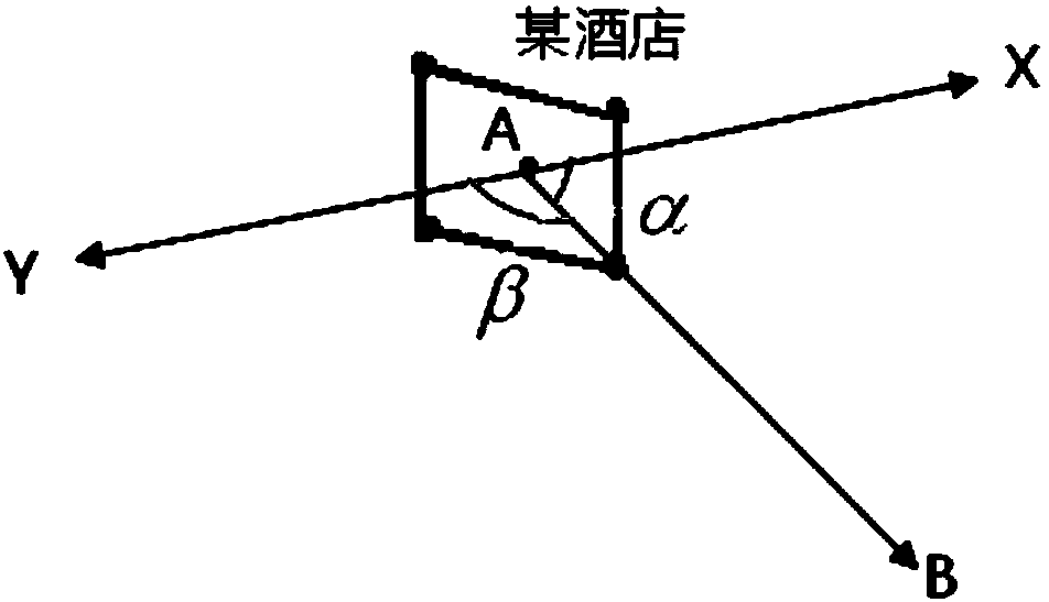
[0018] like figure 1 Shown, the technical scheme that the present invention adopts is that the technical scheme that the present invention adopts is a kind of space vector POI extracting method based on vehicle space information collection, comprises the following steps:

[0019] 1) adopt inertial navigation GPS / IMU combination and laser scanner to obtain street view data and laser cloud points on both sides of the city road, and match street view data and laser cloud points by inertial navigation GPS / IMU combination; The matrix matches the laser cloud points with the panoramic images in the street view data. The specific algorithm is as follows:

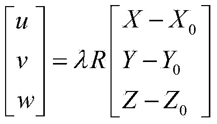
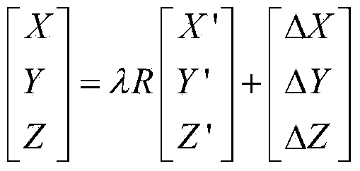
[0020] Let the initial coordinates of the panoramic image data center be [X 0 Y 0 Z 0 ] T , the spherical coordinates of the image point on the panoramic image are [u v w] T , the laser point cloud coordinates corresponding to the image point are [X Y Z] T , the scaling factor is λ, and the rotation matrix is ​​R. Since the ...


PUM


Abstract

The invention relates to a space vector POI extracting method based on vehicle-mounted space information collection. The space vector POI extracting method based on vehicle-mounted space information collection comprises the following steps that street scene data and laser cloud points on the two sides of an urban road are acquired and matched; positions of POI targets are selected in a clicked mode; space vector POIs are acquired; the POIs with space vector information are acquired and include horizontal coordinates, elevation information and orientation information. The space vector POI extracting method based on vehicle-mounted space information collection has the advantages that real three-dimensional POI information is provided for a user, and the accuracy of POI information displaying or skipping is improved.

Description

technical field [0001] The invention relates to the application field of POI maps, in particular to a space vector POI extraction method based on vehicle-mounted space information collection. Background technique [0002] In recent years, the map service has been more and more widely used, and it is mainly for searching information points (Point of Interest, referred to as POI), completing the search of the target or completing the route navigation query and so on. Route query is a widely used technology. At present, information points only contain coordinate information and name information. During the search process, a large number of information points emerge. Especially in route query, it is impossible to judge the direction and destination . [0003] In the Chinese patent literature, the invention patent with the publication number CN103150309A and the name of a spatial direction-aware map interest point search method and system discloses a technical solution (see the ...

Claims


Application Information

Patent Timeline
IPC IPC(8): G06F17/30
CPCG06F16/29
Inventor 陶永亮佘敏胡晓明
Owner SUPER SCENE BEIJING INFORMATION TECH
Why Eureka
Try Eureka