Real-time path planning method and system

A real-time path planning and routing technology, applied in the field of intelligent transportation, can solve problems such as limited range, sparse data information, poor road section prediction ability, etc., and achieve the effect of improving accuracy, wide data range, and uniform samples

Inactive Publication Date: 2014-10-29
BEIJING SOGOU INFORMATION SERVICE +1
View PDF6 Cites 79 Cited by
  • Summary
  • Abstract
  • Description
  • Claims
  • Application Information

AI Technical Summary

Problems solved by technology

[0006] The invention provides a method for real-time path planning, which solves the problems of sparse data inf

Method used


Image

  • Real-time path planning method and system
  • Real-time path planning method and system
  • Real-time path planning method and system

Examples


Embodiment 1

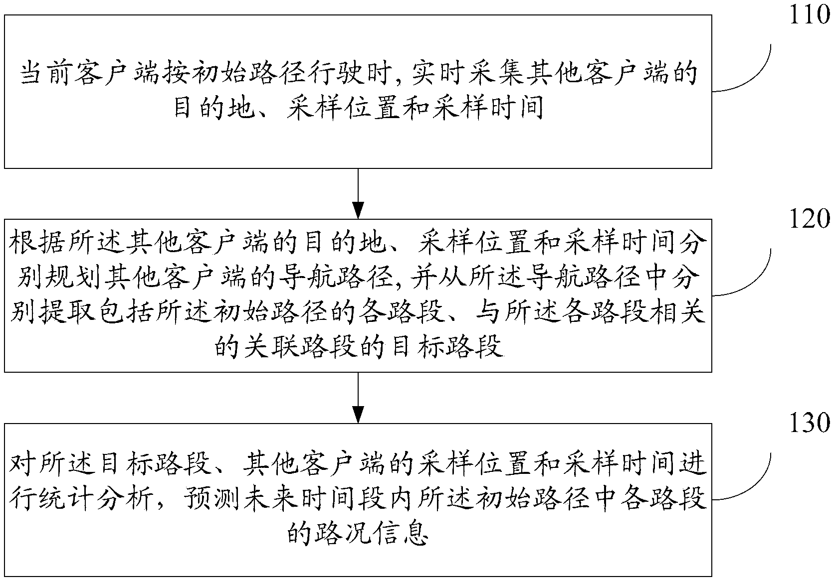
[0053] refer to figure 1 , which shows a schematic flowchart of a method for real-time path planning in Embodiment 1 of the present invention, which may specifically include:

[0054] Step 110, when the current client travels according to the initial route, collect the destination, sampling location and sampling time of other clients in real time;

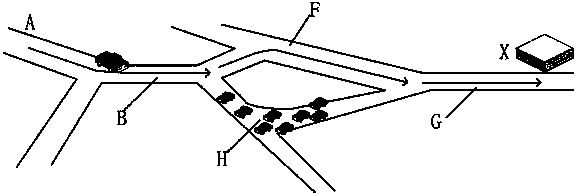
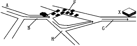
[0055] refer to figure 2 For example, when the current client starts from A to X, the initial path planned for the client is A-B-F-G, then after the initial path is obtained, the destination, sampling location and sampling time of other online clients are collected. In the present invention, It is stipulated to collect at regular intervals. When the current client plans the initial path, it can use general topology methods such as shortest time for planning, and of course other methods can also be used for planning. In the present invention, for the driving process of the vehicle, due to the time delay in the network, the real-...

Embodiment 2

[0098] refer to Figure 4 , which shows a schematic flowchart of a method for real-time path planning according to Embodiment 2 of the present invention.

[0099] In this embodiment, a road condition prediction model can be constructed based on the historical travel information of users in the entire network, and then referenced when planning a route for the client, further increasing data sources, increasing the breadth and depth of data, and further improving the route. planning accuracy.

[0100] This embodiment can specifically include:

[0101] Step 200, according to the sampling location, sampling time and destination of the current client, use the road condition prediction model to plan the optimal initial route;

[0102] In the embodiment of the present invention, the road condition prediction model is obtained by analyzing the user's travel information; the road condition prediction model is obtained by analyzing the user's historical travel information, including: ...

Embodiment 3

[0141] refer to Figure 5 , which shows a schematic structural diagram of a real-time path planning system according to Embodiment 3 of the present invention, which may specifically include:

[0142] The collection module 310 is used to collect destinations, sampling locations and sampling times of other clients in real time when the current client is traveling by the initial route;

[0143] The associated road segment extraction module 320 is used to plan the navigation paths of other clients respectively according to the destinations, sampling locations and sampling times of the other clients, and respectively extract each road segment including the initial path from the navigation path, and the Describe the target road section of the associated road section related to each road section;

[0144] The congestion judging module 330 is configured to perform statistical analysis on the target road section, sampling locations and sampling times of other clients, and predict road...


PUM


Abstract

Relating to the technical field of intelligent traffic, the invention provides a real-time path planning method and system. The method includes: when a current client drives according to an initial path, collecting the destinations, sampling locations and sampling time of other clients in real time; planning the navigation paths of the other clients according to the destinations, sampling locations and sampling time respectively, and extracting all sections containing the initial path and target sections of relevant sections associated with all the sections from the navigation paths respectively; and carrying out statistical analysis on the target sections and the sampling locations and sampling time of the other clients, and forecasting the traffic information of each section in the initial path in a future period of time. The method and system provided by the invention have the characteristics of wide data range and even sample, improve the accuracy of the path planning result, especially for traffic variation without obvious regularity, and improve the accuracy of path planning.

Description

technical field [0001] The invention relates to the technical field of intelligent transportation, in particular to a method and system for real-time path planning. Background technique [0002] Road path planning is a typical application in the field of GPS technology, and it has been widely used at present. In the existing technology, path planning is often based on the topological relationship of the road network, considering the basic attributes of the road network, such as the grade of the road, the number of lanes, the number of intersections, the number of traffic lights and other basic attributes, and using the topology algorithm to give the starting point and Path schemes such as the shortest total distance between the destinations or the shortest total time-consuming. [0003] The traditional path planning method is to use the speed of GPS historical records of some vehicles on the highway to judge the smoothness of this road section at the sampling time. If the s...

Claims


Application Information

Patent Timeline
IPC IPC(8): G01C21/34
CPCG01C21/3492G01C21/3415
Inventor 张帆柴思远张阔
Owner BEIJING SOGOU INFORMATION SERVICE
Why Eureka
Try Eureka