Registration method and system of remote sensing image and laser point cloud based on road features

A laser point cloud and remote sensing image technology, which is applied in image analysis, image data processing, instruments, etc., can solve the problem of uneven distribution of laser point cloud data, inability to extract the edges and corners of building structures, and the accuracy of building outlines. The problem of low detail, etc., can avoid the loss of precision, be more identified, and reduce the search range.

Inactive Publication Date: 2016-09-14
WUHAN UNIV
View PDF2 Cites 0 Cited by
  • Summary
  • Abstract
  • Description
  • Claims
  • Application Information

AI Technical Summary

Problems solved by technology

For urban areas with dense buildings, due to the discreteness and uneven distribution of laser point cloud data, the accuracy and detail of the extracted building outlines are not high; and because of the occlusion of aerial remote sensing images, the structure of some buildings Edges and corners cannot be extracted

Method used


Image

  • Registration method and system of remote sensing image and laser point cloud based on road features
  • Registration method and system of remote sensing image and laser point cloud based on road features
  • Registration method and system of remote sensing image and laser point cloud based on road features

Examples


Embodiment Construction

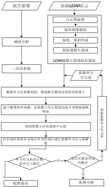
[0060] The method of the present invention extracts the point cloud road vector line based on the laser point cloud data, and uses it as a registration primitive, and uses the improved rectangular overall matching method to automatically extract the remote sensing image road information to obtain the image road centerline, that is, to realize the laser point cloud road vector The matching of the line and the image road centerline; finally, the outer orientation elements of the remote sensing image are recalculated using the feature endpoints of the line with the same name to complete the registration of the two data.

[0061] The extraction of point cloud road vector lines mainly analyzes the attribute characteristics and basic morphological features of the road, uses the three-dimensional coordinate information and intensity information of laser point cloud data, and combines mathematical morphology knowledge to extract the road centerline, that is, the feature of point cloud r...


PUM


Abstract

The invention provides a high-resolution remote sensing image and laser point cloud registration method and system based on road features, including steps: step 1, extracting point cloud road vector lines according to the laser point cloud; step 2, orthophoto of the remote sensing image Preprocess to obtain the binarized segmented image; Step 3, use the initial external orientation element to back-project the point cloud road vector line to the binarized segmented image, and use the rectangular overall matching method to obtain the image road centerline; Step 4, use the point cloud The endpoint of the road vector line is the ground control point, and the endpoint of the image road center line is the image point of the ground control point to realize the registration of the laser point cloud and the remote sensing image. The invention can realize fast, automatic and high-precision registration between multi-source data, and provide reference for the extraction of ground objects after fusion, three-dimensional reconstruction and change detection.

Description

technical field [0001] The invention belongs to the technical field of remote sensing and photogrammetry, in particular to a method and system for registering remote sensing images and laser point clouds based on road features. Background technique [0002] Unmanned aircraft (Unmanned Aerial Vehicle, UAV) is a powered, controllable, capable of carrying a variety of mission equipment, performing a variety of tasks, and reusable unmanned aerial vehicles. Through the combination of unmanned aerial vehicle technology and remote sensing sensor technology, telemetry and remote control technology, communication technology, GPS differential positioning technology and remote sensing application technology, the UAV remote sensing system can quickly obtain space remote sensing information of land, resources, environment, etc., through ground The receiving station performs remote sensing data processing to realize automation, intelligence, and thematic modeling and analysis. In particu...

Claims


Application Information

Patent Timeline
Patent Type & Authority Patents(China)
IPC IPC(8): G06T7/00
Inventor 万幼川何培培秦家鑫杨威
Owner WUHAN UNIV
Why Eureka
Try Eureka