
Method for monitoring forest fire by means of combination of infrared and multi-spectral wave bands

A forest fire and multi-spectral technology, applied in the field of forest fire monitoring, can solve the problems of not being able to identify the location of the fire point, misjudgment, and no spectral information, so as to facilitate the analysis and identification of fire development by leaders and reduce the effect of misjudgment

Active Publication Date: 2014-12-24
CHINA CENT FOR RESOURCES SATELLITE DATA & APPL
View PDF5 Cites 19 Cited by
  • Summary
  • Abstract
  • Description
  • Claims
  • Application Information

AI Technical Summary

Problems solved by technology

However, infrared images are black and white, without spectral information, which is prone to misjudgment of fire
[0004] The multi-spectral image of Environment-1B can identify the spreading fire and the smoke caused by the fire, and can also extract the affected area of ​​the forest fire that has been extinguished and calculate the fire area, but due to the influence of smoke, it cannot be used in the multi-spectral image The location of the ignition point is clearly identified on the

Method used


Image

  • Method for monitoring forest fire by means of combination of infrared and multi-spectral wave bands
  • Method for monitoring forest fire by means of combination of infrared and multi-spectral wave bands
  • Method for monitoring forest fire by means of combination of infrared and multi-spectral wave bands

Examples


Embodiment Construction

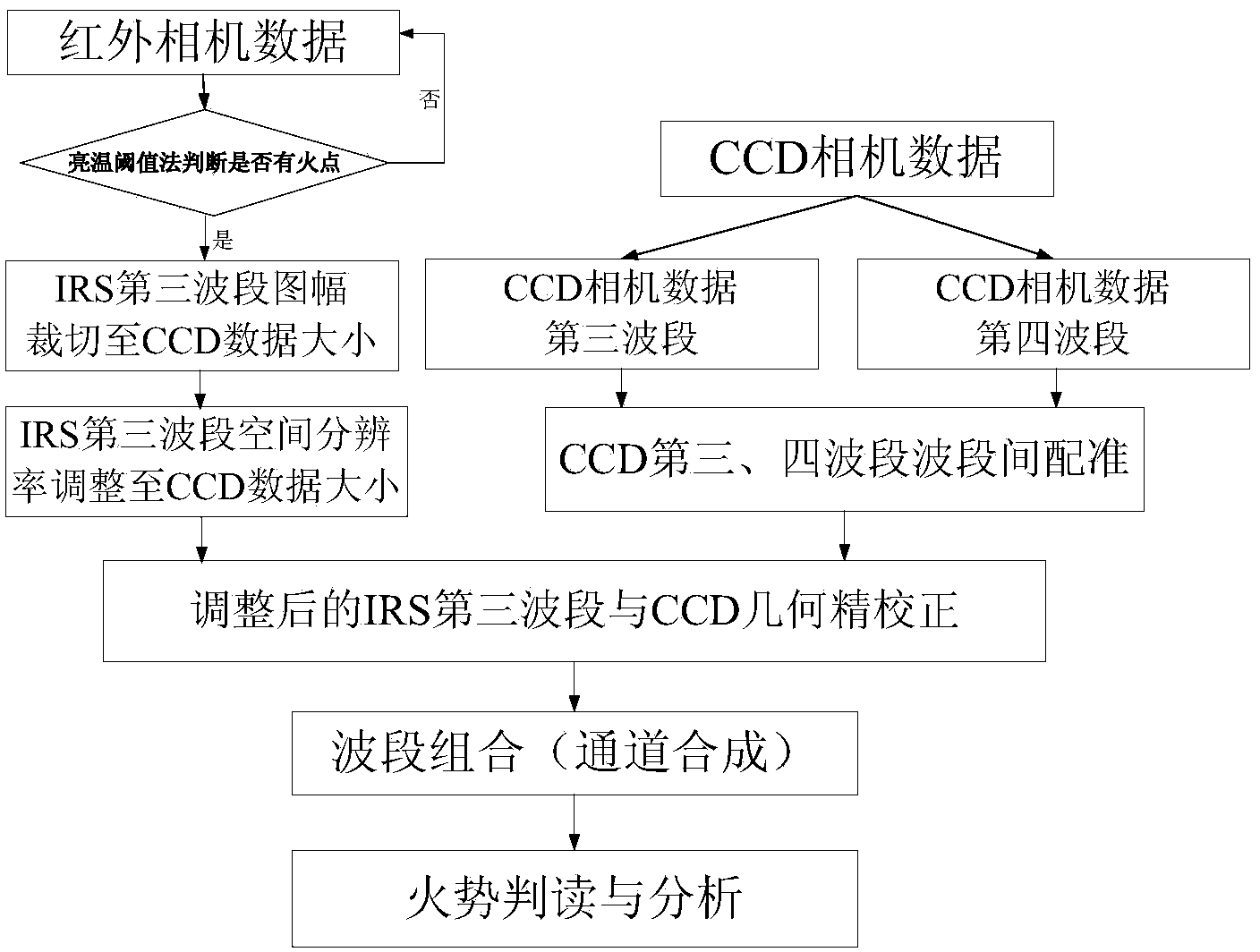
[0023] The present invention will be described in detail below in conjunction with the drawings, such as figure 1 As shown, the steps are as follows:

[0024] (1) Select the CCD data and infrared IRS data collected by the HJ-1B satellite (HJ-1B) on the same day. Among them, the third band of the CCD camera is the red band, the fourth band is the near-red band, the third band of the IRS camera is the mid-infrared band, and the fourth band is the thermal infrared band. According to the characteristics of the fire, the third and fourth bands of the CCD camera and the third band of the IRS camera are selected as the raw data.

[0025] (2) Calculate the radiance of the infrared camera data collected in step (1), and judge whether there is a fire spot in the image, if there is a fire spot, go to step (3), otherwise return to step (1) to perform data collection again;

[0026] When a fire occurs, the flame temperature can even reach about 1000K, and the temperature between the flame and th...


PUM


Abstract

The invention provides a method for monitoring a forest fire by means of combination of infrared and multi-spectral wave bands. The method includes the steps that (1) CCD camera data and infrared camera data collected by an environment satellite on the same day are selected; the third wave band namely an infrared wave band and the fourth wave band namely a near infrared wave band of a CCD camera and the third wave band namely an infrared wave band of an infrared camera are selected; (2) radiation brightness calculation is carried out on the collected infrared camera data, whether fire points exist is judged primarily, if the answer is positive, the step (3) is carried out and otherwise, the step (1) is carried out again for data collection; (3) data of the third wave band of the infrared camera are adjusted so that the infrared camera can keep consistent with the CCD camera in mapsheet and space resolution ratio; (4) precise geometric rectification is carried out on the adjusted CCD camera data and the adjusted infrared camera data; (5) the third wave band of the CCD undergoing precise geometric rectification serves as a new first wave band, the fourth wave band serves as a new second wave band, the third wave band of the infrared camera serves as a new third wave band and the forest fire is monitored by means of a newly obtained image.

Description

Technical field [0001] The invention relates to a method for monitoring forest fires. Background technique [0002] Forest fires are a kind of worldwide major disasters that occur every year and endanger forest resources. Every forest fire brings serious damage and loss to forest vegetation, forest ecosystems, global ecological environment, and human life and property. The destructive impact on ecosystems may last dozens to hundreds of years. [0003] The third-band spectral range of the infrared multi-spectral camera of Environmental One B star is 3.50μm~3.90μm. It is sensitive to the identification of high-temperature targets such as fires and active volcanoes. Especially for forest fires, it can not only clearly display fire points and lines of fire. The shape, size, and location of the fire, and also has a strong ability to recognize small hidden fires and overfires. However, the infrared image is black and white, and there is no spectral information, which is prone to misjud...

Claims


Application Information

Patent Timeline
IPC IPC(8): G08B17/12G01J5/60
Inventor 龚亚丽郭朝辉李杏朝傅俏燕潘志强
Owner CHINA CENT FOR RESOURCES SATELLITE DATA & APPL
Learn More