A method for on-orbit evaluation of remote sensing image change detection performance

A remote sensing image and change detection technology, applied in image enhancement, image analysis, image data processing, etc., can solve problems such as automatic and accurate evaluation difficulties, and achieve reliable evaluation, reduced computing time, and strong robustness

Active Publication Date: 2017-05-10
INST OF AUTOMATION CHINESE ACAD OF SCI
View PDF4 Cites 0 Cited by
  • Summary
  • Abstract
  • Description
  • Claims
  • Application Information

AI Technical Summary

Problems solved by technology

However, the above-mentioned particularities of on-orbit change detection make it very difficult to evaluate change detection performance on-orbit, automatically, and accurately only by relying on images

Method used


Image

  • A method for on-orbit evaluation of remote sensing image change detection performance
  • A method for on-orbit evaluation of remote sensing image change detection performance
  • A method for on-orbit evaluation of remote sensing image change detection performance

Examples


Embodiment Construction

[0017] The technical problems involved in the technical solution of the present invention will be described below in conjunction with the accompanying drawings. It should be pointed out that the described embodiments are only intended to facilitate the understanding of the present invention, rather than limiting it in any way.

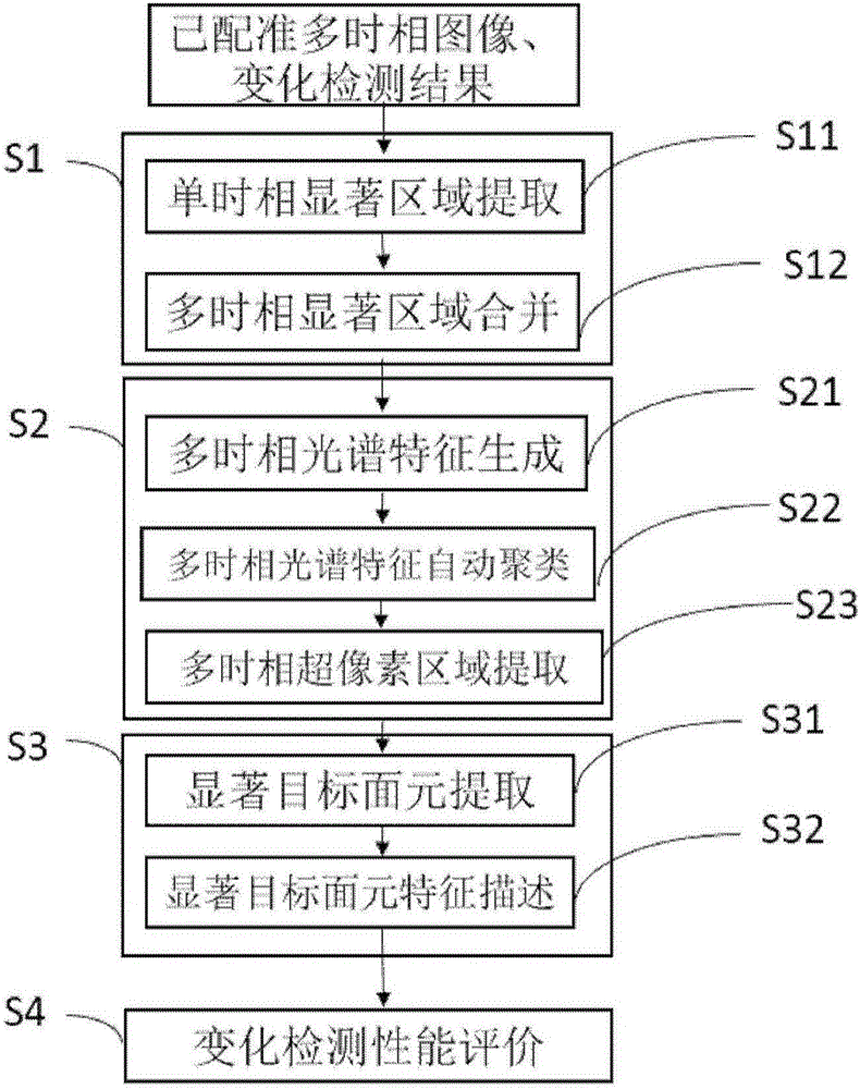
[0018] Such as figure 1 It shows that the present invention proposes a method for on-orbit evaluation of remote sensing image change detection performance, which method includes the following steps:

[0019] Step S1: Multi-temporal salient region extraction uses the sign function of the discrete cosine transform of image grayscale as the saliency metric, first extracts salient regions on the current remote sensing image and historical remote sensing images, and then takes the union of the salient regions as a multi-temporal Salient regions of the phase image. The specific process of extracting the multi-temporal salient region is as follows:

[0020...


PUM


Abstract

The invention relates to a method for on-orbit evaluation of remote sensing image change detection performance. The method includes the steps: step S1, taking a sign function of discrete cosine transform of remote sensing image gradation as a significance measurement standard to respectively extract significant areas on a current remote sensing image and a historical remote sensing image, and taking a union set of the significant areas as a significant area of a multi-temporal image; step S2, performing automatic clustering on multi-temporal image spectral signatures generated by the current remote sensing image and the historical remote sensing image, and extracting multi-temporal ultra-pixel areas according to clustering classes and spatial position relation; step S3, respectively extracting significant target surface elements in the multi-temporal ultra-pixel areas of the current remote sensing image and the historical remote sensing image, and describing each significant target surface element with structural features; step S4, carrying out on-orbit evaluation of to-be-evaluated target area change detection result performances according to inter-class separability of change class and non-change class of structural features of each significant target surface element.

Description

technical field [0001] The invention relates to the technical fields of remote sensing image processing and target online monitoring, in particular to an on-orbit evaluation method for change detection performance of spaceborne multi-temporal remote sensing images. Background technique [0002] Change detection refers to the process of detecting the change area by using the registered multi-temporal remote sensing images of the same location. Change detection is a key technique for numerous applications such as object discovery, disaster monitoring, and urban geographic information updating. At present, with the development of remote sensing satellites with high spatial resolution and high temporal resolution, there is a strong application demand for on-orbit and automatic change detection of remote sensing satellites. [0003] On-orbit change detection has special requirements compared to traditional change detection tasks performed on ground processing systems. First of ...

Claims


Application Information

Patent Timeline
Patent Type & Authority Patents(China)
IPC IPC(8): G06T7/00
CPCG06T7/0002G06T2207/10032
Inventor 霍春雷潘春洪周志鑫
Owner INST OF AUTOMATION CHINESE ACAD OF SCI
Why Eureka
Try Eureka