
Pole tower microgravity altitude measurement method based on Beidou satellite system

A Beidou satellite and microgravity technology, applied in the field of satellite altimetry, can solve the problems of untimely and inaccurate detection data, and cannot grasp the operation status well, and achieve the effects of easy observation, accident avoidance and accurate data

Inactive Publication Date: 2015-02-25
STATE GRID CORP OF CHINA +2
View PDF0 Cites 1 Cited by
  • Summary
  • Abstract
  • Description
  • Claims
  • Application Information

AI Technical Summary

Problems solved by technology

[0003] Most of the existing tower measurement methods have limitations and are affected by geographical factors and the surrounding environment; or the detection data is not timely and accurate enough to grasp its operating status well

Method used


Image

  • Pole tower microgravity altitude measurement method based on Beidou satellite system

Examples


Embodiment Construction

[0012] In order to make the object, technical solution and advantages of the present invention clearer, the present invention will be further described in detail below in conjunction with the accompanying drawings and embodiments. It should be understood that the specific embodiments described here are only used to explain the present invention, not to limit the present invention.

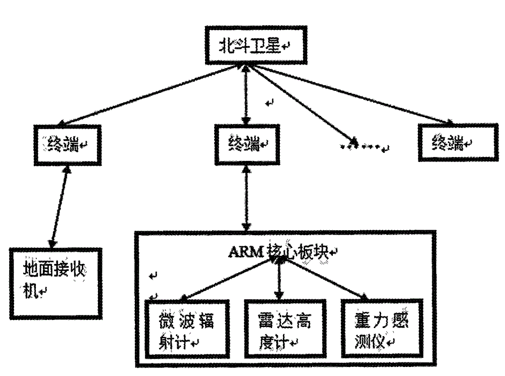
[0013] A microgravity altimetry method for towers based on the Beidou satellite system, comprising Beidou satellites, Beidou terminals, monitoring node equipment and ground receivers, characterized in that: the Beidou satellites and Beidou terminals form a Beidou information communication system, and the ground receivers can be The data monitored by the monitoring node equipment is received through the Beidou communication system. The monitoring node equipment has an ARM core board that is interactively connected with the Beidou communication terminal. The ARM core board in the monitoring node devic...


PUM


Abstract

The present invention discloses a pole tower microgravity altitude measurement method based on a Beidou satellite system. According to the pole tower microgravity height measurement method, a Beidou satellite, a Beidou terminal, monitoring node equipment and a ground receiver are adopted, wherein the Beidou satellite and the Beidou terminal form a Beidou information communication system, the ground receiver can receive the data monitored by the monitoring node equipment through the Beidou communication system, the monitoring node equipment is provided with an ARM core plate connected with the Beidou communication terminal, and the ARM core plate in the monitoring node equipment is further connected with a microwave radiometer, a radar altimeter and a gravity sensing instrument. According to the invention, with the detection on the microgravity, the altitude of the pole tower can be accurately determined, wherein the altitude measurement resolution can be 3.24 mm, such that the pole tower operating condition can be effectively controlled, and the appropriate measures can be taken before the accident so as to avoid the occurrence of the accident.

Description

technical field [0001] The invention relates to the field of satellite height measurement, in particular to a tower microgravity height measurement method based on the Beidou satellite system. Background technique [0002] Many power facilities are built in areas with unstable surface, such as areas prone to geological disasters. Due to factors such as landslides and continuous subsidence of the ground, power facilities (such as transmission line towers) will sink. Once the subsidence exceeds the limit, the transmission line towers will be damaged. will collapse. Secondly, natural disasters such as freezing rain also increase the ice and snow load on the power transmission line. When the load exceeds a certain limit, the power transmission line tower is overwhelmed, deformed, and even collapsed, causing huge losses. Therefore, it is necessary to monitor the height of transmission line towers in real time, grasp their operating status in time, and take corresponding measures...

Claims


Application Information

Patent Timeline
Patent Type & Authority Applications(China)
IPC IPC(8): G01C5/00G08C17/02G01S19/01
CPCG01C5/00G01S19/01
Inventor 郭振河盛俊英张峻林朱兵邵名声程升平程金松凌晓斌
Owner STATE GRID CORP OF CHINA
Learn More