

Precision evaluation method and system for remote sensing estimation of surface sensible heat/latent heat flux
Patent Information
- Authority / Receiving Office
- CN · China
- Current Assignee / Owner
- CHONGQING SURVEY INST
- Publication Date
- 2015-03-11
- Estimated Expiration
- Not applicable · inactive patent
Smart Images
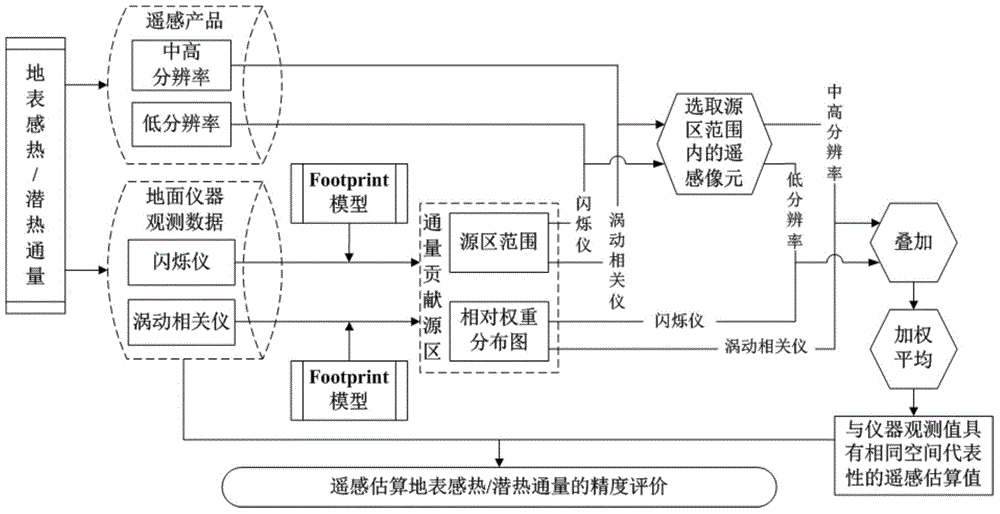
Figure 1 
Figure 2 
Figure 3
Abstract
Description
technical field
[0001] The invention relates to the technical field of verification of remote sensing products, in particular to a precision evaluation method and system for remote sensing estimation of surface sensible / latent heat flux. Background technique
[0002] For surface sensible heat and latent heat flux, the remote sensing estimation results are arranged in pixels, and the size of each pixel is fixed. On the other hand, the flux values observed by ground instruments, the size and position of the spatial range represented by them are not fixed, and are generally related to the height of the instrument, wind direction and speed, atmospheric stability, and the condition of the underlying surface, etc., and will continue to change over time. . Therefore, in the process of verification, there is a problem of mismatching of spatial representative ranges, and it is impossible to make one-to-one correspondence on the pixel scale. At present, for the verification of sur...