Air-ground coordinated multi-constellation satellite navigation integrity multi-stage monitoring method

A technology of satellite navigation and air-ground coordination, applied in satellite radio beacon positioning systems, measurement devices, radio wave measurement systems, etc., can solve problems such as limited performance, inability to guarantee navigation integrity, and huge cost, so as to ensure navigation integrity Effect

Active Publication Date: 2015-04-01
天宇航空数据科技(合肥)有限责任公司
View PDF4 Cites 38 Cited by
  • Summary
  • Abstract
  • Description
  • Claims
  • Application Information

AI Technical Summary

Problems solved by technology

The traditional navigation autonomous integrity monitoring method can meet the integrity requirements of civil aviation for non-precision approaches in the route and terminal area, but it still has the following two limitations: First, the traditional navigation autonomous integrity monitoring method is mainly aimed at single navigation system, when the visibility of navigation satellites decreases or the geometric characteristics of navigation satellites are not ideal, traditional navigation autonomous integrity monitoring methods cannot achieve efficient satellite fault detection, and thus cannot guarantee navigation integrity; secondly, due to limited performance, traditional The existing navigation autonomous integrity monitoring method cannot meet the integrity requirements of APV, LPV200 and other flight phases
The traditional satellite navigation autonomous integrity monitoring method (RAIM) realizes the detection of satellite faults by establishing a statistical detection model of navigation quantity measurement and estimation errors. The performance of this method is affected by the aircraft operating environment and the computing power of airborne equipment. Under the reference of satellite state prior information, this method cannot meet the high integrity requirements
Although researchers have successively proposed Ground Integrity Channel (GIC) and Satellite-Based Augmentation System (SBAS) to enhance integrity, these methods require the deployment of more ground stations, and the system is complex and costly

Method used


Image

  • Air-ground coordinated multi-constellation satellite navigation integrity multi-stage monitoring method
  • Air-ground coordinated multi-constellation satellite navigation integrity multi-stage monitoring method
  • Air-ground coordinated multi-constellation satellite navigation integrity multi-stage monitoring method

Examples


Embodiment Construction

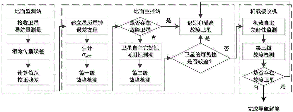
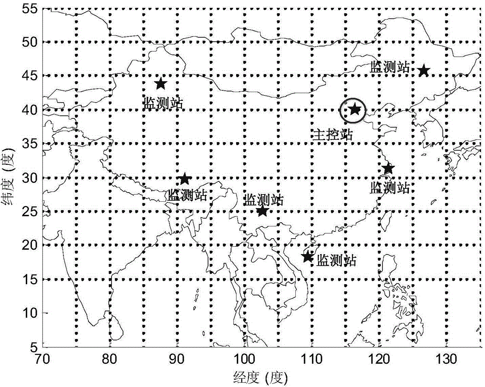
[0059] The specific implementation of the present invention will be described in detail below in conjunction with the accompanying drawings. The description takes the autonomous integrity monitoring of GPS and Beidou dual constellations as an example. The operating scenario considers LPV200 and selects 7 ground monitoring stations. The distribution diagram is as follows figure 2 shown.

[0060] The pseudorange measurement of each ground monitoring station can be expressed as:

[0061] Where j represents the satellite number, m represents the ground monitoring station number, For pseudorange measurement, is the geometric distance between the satellite and the monitoring station. ΔE j Indicates the satellite ephemeris error, represents the ionospheric error, Indicates the tropospheric error. b m Indicates the receiver clock bias, B j is the satellite clock error, is the pseudorange residual caused by multipath and thermal noise.

[0062] The following scheme is...


PUM


Abstract

The invention discloses an air-ground coordinated multi-constellation satellite navigation integrity multi-stage monitoring method. The method is suitable for monitoring multi-constellation satellite navigation integrity. The method comprises the following steps: receiving navigation observation quantity through a ground monitoring station; estimating and monitoring an ephemeris error and a star clock error of a satellite space signal, and carrying out availability prediction of satellite navigation autonomous integrity monitoring on an air route in a region, and broadcasting the result to an airplane. Airborne navigation equipment detects whether a fault exits in a received navigation satellite or not by using prior information of terrestrial broadcasting, so as to determine the navigation integrity of the flight. Compared with a traditional RAIM detection method, the detection probability of satellite faults can be improved; the requirements of relatively low false alarm probability and false dismissal probability can be met, thus the navigation continuity and availability are improved; through multi-constellation joint integrity monitoring, relatively high navigation availability can be obtained; relatively good navigation reliability, and performance analysis of a positioning error caused by the minimum detection deviation can be realized.

Description

technical field [0001] The invention relates to the field of autonomous integrity monitoring of aviation navigation, in particular to a multi-level monitoring method for air-ground coordination multi-constellation satellite navigation integrity. Background technique [0002] In recent years, the demand for integrity monitoring in aviation navigation has been increasing. The airborne system not only needs to receive navigation observations, but also needs to identify whether the received navigation observations can meet the high-security positioning requirements. The traditional navigation autonomous integrity monitoring method can meet the integrity requirements of civil aviation for non-precision approaches in the route and terminal area, but it still has the following two limitations: First, the traditional navigation autonomous integrity monitoring method is mainly aimed at single navigation system, when the visibility of navigation satellites decreases or the geometric ...

Claims


Application Information

Patent Timeline
Patent Type & Authority Applications(China)
IPC IPC(8): G01S19/20
CPCG01S19/20
Inventor 刘杨薛瑞方堃
Owner 天宇航空数据科技(合肥)有限责任公司
Why Eureka
Try Eureka