Method for determining quasigeoid models by utilizing deviation of plumb line and gravity anomaly

A geoid and vertical line deviation technology, applied in surveying and navigation, height/horizontal measurement, measuring devices, etc., can solve the problem of high cost, low resolution of gravity data grid, and high-frequency information that is difficult to resemble the actual geoid Control and other issues, to achieve the effect of high precision and high efficiency

Inactive Publication Date: 2015-05-13
THE PLA INFORMATION ENG UNIV
View PDF2 Cites 27 Cited by
  • Summary
  • Abstract
  • Description
  • Claims
  • Application Information

AI Technical Summary

Problems solved by technology

[0004] At present, the general quasi-geoid modeling method is to directly calculate the elevation anomaly of a point according to the Molodensky theory combined with the earth's gravity field model, gravity, terrain and other data, and then use GPS / leveling to fit the poor system, because the quasi-geoid cannot effectively absorb High-frequency information such as terrain and it is difficult to use GPS / leveling data to actually control the quasi-geoid, so it is difficult to greatly improve the accuracy of the quasi-geoid
The method of determining the quasi-geoid mainly relies on dense GPS / leveling, which is not only costly, but also has a low resolution of the quasi-geoid model due to the low resolution of the gravity data grid used
[0005] Since the vertical deviation is sensitive to high-frequency topographical information, a high-precision numerical model of the vertical deviation can be established based on the Molodensky theory combined with data such as the earth's gravity field model, gravity, and topography. The method of gravity leveling calculates the relative elevation anomaly difference, and then imposes constraints on it with GPS / leveling control points, and finally adopts the method of adjustment to obtain the elevation anomaly, so as to establish a high-precision and high-resolution quasi-geoid model, but so far it has not See a public report on the method of determining quasi-geoid model using vertical deviation and gravity anomaly

Method used


Image

  • Method for determining quasigeoid models by utilizing deviation of plumb line and gravity anomaly
  • Method for determining quasigeoid models by utilizing deviation of plumb line and gravity anomaly
  • Method for determining quasigeoid models by utilizing deviation of plumb line and gravity anomaly

Examples


Embodiment Construction

[0025] The specific implementation of the present invention will be described in detail below in conjunction with the accompanying drawings and specific conditions.

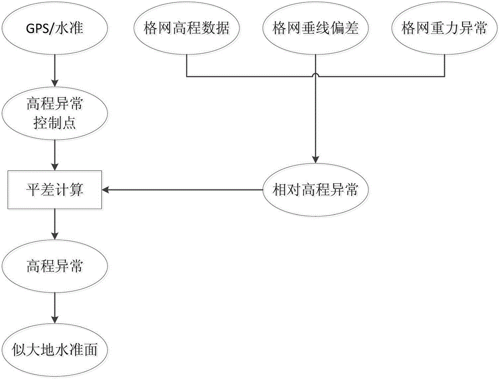
[0026] Depend on figure 1 As shown, the present invention includes setting GPS / leveling points, elevation abnormal control points, calculation of grid elevation data, grid vertical deviation, and grid gravity anomalies in the specific implementation, and obtaining relative elevation anomaly difference and elevation anomaly control points The elevation anomaly is obtained through the adjustment calculation, so as to construct the quasi-geoid model, which is specifically realized by the following steps:

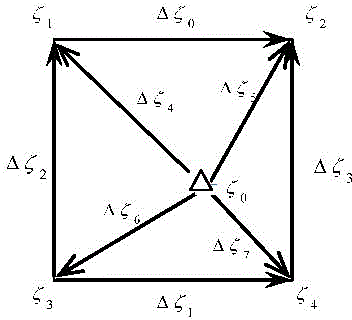
[0027] 1. Calculation of the relative elevation anomaly difference of the grid: According to the differential relationship of the elevation anomaly, the grid relative elevation anomaly difference is calculated from the grid vertical line deviation and the gravity anomaly, and the calculation formula is:

[0028] ...


PUM


Abstract

The invention relates to a method for determining quasigeoid models by utilizing deviation of plumb line and gravity anomaly, and aims at effectively improving the modeling precision of quasigeoid and solving the determination problem of height datum in geodetic surveying. The method comprises the following steps: by adopting the differential relation of height anomalies, computing the grid relative height anomaly difference via the deviations of plumb lines and gravity anomalies of the grids; imposing restriction through a GPS / benchmark to obtain height anomaly of grid nodes, and computing the relative height anomaly difference between adjacent nodes by utilizing the deviation of plumb line, gravity anomaly and digital height data of each node; computing the height anomaly difference of adjacent grids, carrying out adjustment computation by a parameter adjustment model and determining the quasigeoid models; selecting three million-sheet 4 DEG*6 DEG areas with deviations of plumb lines, gravity anomalies and terrain grid data to respectively computing and establishing the quasigeoid models of the three areas, and analyzing the precision. The method provided by the invention is novel, unique, high in efficiency and high in precision, and is an innovation in geodetic surveying.

Description

technical field [0001] The invention relates to the field of geodesy, in particular to a method for determining a quasi-geoid model by using vertical line deviation and gravity anomaly. Background technique [0002] The quasi-geoid is a geometric surface formed by measuring the normal height from the ground point, which can be regarded as the starting surface of the ground point elevation in the normal height system. The traditional elevation datum is established by leveling and represented by leveling stones, but today, this traditional way is changing. The digital elevation datum represented by the grid geoid established by the gravity field data has become a development trend. It provides the necessary basis for three-dimensional measurement using satellite positioning technology, and also avoids the maintenance difficulties of leveling stones. Establishing a high-resolution and high-precision quasi-geoid model has become one of the main tasks of current geodetic survey...

Claims


Application Information

Patent Timeline
Patent Type & Authority Applications(China)
IPC IPC(8): G01C5/00
CPCG01C5/00
Inventor 李姗姗吴晓平柴洪洲王庆宾邢志斌孙文赵东明李新星王伟张金辉
Owner THE PLA INFORMATION ENG UNIV
Why Eureka
Try Eureka