Supercharge Your Innovation With Domain-Expert AI Agents!

A Method of Quickly Loading Spatial Data in 3D GIS

A technology for loading space and spatial data, applied in image data processing, structured data retrieval, electronic digital data processing, etc., can solve the problems of high maintenance costs, achieve the effects of reducing maintenance costs, satisfying real-time display, and improving loading speed

Active Publication Date: 2018-08-03
KARAMAY HONGYOU SOFTWARE
View PDF6 Cites 0 Cited by
  • Summary
  • Abstract
  • Description
  • Claims
  • Application Information

AI Technical Summary

Problems solved by technology

[0004] Therefore, a technical problem that needs to be solved urgently by those skilled in the art is: how to find a method for real-time and fast loading of spatial data, so as to effectively solve the problem of high maintenance cost existing in the current method of loading spatial data based on raster data

Method used


Image

  • A Method of Quickly Loading Spatial Data in 3D GIS

Examples


Embodiment Construction

[0034] The present invention is described in detail below in conjunction with accompanying drawing:

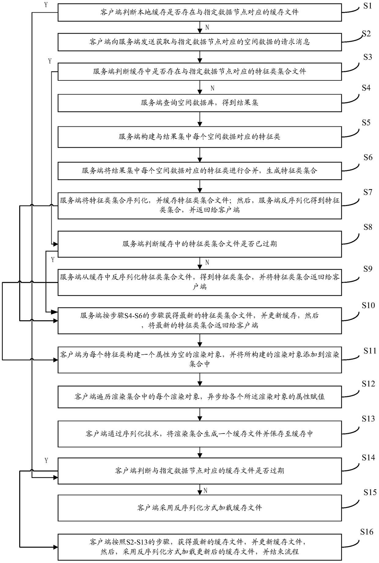
[0035] Such as figure 1 As shown, the present invention provides a kind of method of three-dimensional GIS fast loading space data, comprises the following steps:

[0036] S1, when the client needs to load and display the spatial data corresponding to the specified data node, the client first reads the local cache to determine whether there is a cache file corresponding to the specified data node in the local cache, if not, then Execute S2-S13; if exists, execute S14;

[0037] S2. The client sends to the server a request message for acquiring spatial data corresponding to the specified data node;

[0038] S3, the server reads the local cache, and judges whether there is a feature class collection file corresponding to the specified data node in the cache; if it does not exist, execute S4-S7; if it exists, execute S8;

[0039] S4, the server queries the spatial database base...


PUM


Abstract

The invention provides a method for quickly loading space data through a three-dimensional GIS (global information system). The method comprises the following steps: inquiring a database based on a determined data node through a service side to obtain a result set; constructing characteristic sets; returning the characteristic sets to a client side through the service side; constructing a rendering object with null attributes is constructed for each characteristic set through the client side, and adding the constructed rendering object into a rendering set; scanning each rendering object in the rendering set through the client side, asynchronously assigning the attribute of each rendering object; generating a cache file for the rendering object and storing the cache file into a cache. According to the method for quickly loading space data through the three-dimensional GIS, various technical means are adopted, the space data loading rate is completely increased, the real-time display needs of the space data are met better, and the maintenance cost of the space data is effectively lowered.

Description

technical field [0001] The invention belongs to the technical field of computer graphics, and in particular relates to a method for quickly loading spatial data in a three-dimensional GIS. Background technique [0002] At present, the known three-dimensional GIS (Geographic Information System, Geographic Information System) method for loading spatial data is: first, the spatial data stored in the spatial database is rasterized; then, the generated raster data is published on the server ; Finally, the client directly reads the raster data on the server and loads it into the image. [0003] The main problem of this method is: because the raster data is static pre-processed data, the raster data will not read the spatial database in real time, and it is published to the server in the form of a file. Therefore, when updating When the spatial database is used, it cannot be reflected in the raster data. Therefore, when the spatial database is updated, the rasterized data must be ...

Claims


Application Information

Patent Timeline
Patent Type & Authority Patents(China)
IPC IPC(8): G06T17/05G06F17/30
CPCG06F16/29G06T17/05
Inventor 郭勇
Owner KARAMAY HONGYOU SOFTWARE
Features
  • R&D
  • Intellectual Property
  • Life Sciences
  • Materials
  • Tech Scout
  • Unparalleled Data Quality
  • Higher Quality Content
  • 60% Fewer Hallucinations
Learn More