Urban digital map three-dimensional modeling manufacturing method

A digital map and 3D modeling technology, applied in 3D modeling, image data processing, instruments, etc., can solve the problems of inconvenient extraction, inconvenience in life and work, large storage space, etc., and achieve convenient storage and transmission, map capacity, etc. Small, good user experience

Active Publication Date: 2015-05-27
南京市测绘勘察研究院股份有限公司
View PDF6 Cites 48 Cited by
  • Summary
  • Abstract
  • Description
  • Claims
  • Application Information

AI Technical Summary

Problems solved by technology

Common digital maps are mainly represented by picture format files. The data volume of picture format files is very large, requiring a large storage space, and it is difficult to achieve scaling and high resolution. Large data volume means longer transmission time. In the case of limited network transmission speed, users have to wait for a long time for the display of the map, which will seriously affect the customer experience
Secondly, the current digital maps (such as Google Maps, Baidu Maps, etc.) only focus on roads and rivers, ignoring urban maps in the map, such as urban landforms, urban buildings, urban greening, regional management, economic circles, The drawing and representation of business circles, in today’s digital age, is inconvenient for users to extract urban planning and construction information such as urban landforms, urban buildings, urban greening, regional management, economic circles, and business circles from existing digital maps. Bring a lot of inconvenience to people's life and work

Method used


Image

  • Urban digital map three-dimensional modeling manufacturing method

Examples


Embodiment Construction

[0030] In order to clarify the technical scheme and technical purpose of the present invention, the present invention will be further introduced below in conjunction with the accompanying drawings and specific implementation methods.

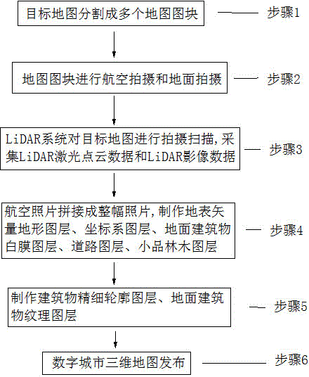
[0031] Such as figure 1 As shown, a method for making three-dimensional modeling of a city digital map of the present invention, in order to facilitate the technical points of the technical solution of the present invention, the following uses the three-dimensional modeling of a city digital map of a certain city as an example to illustrate, in this example Among them, the coordinate system of the map adopts the 92 local coordinate system, and the elevation system adopts the Wusong elevation system; depending on the preference of the maker or user, different coordinate system transformations can be carried out. The coordinate transformations are all recorded in the literature, and will not be stated here. . The image processing software used in...


PUM


Abstract

The invention discloses an urban digital map three-dimensional modeling manufacturing method which comprises the following steps: encoding and identifying map blocks divided from a target map; acquiring aerial images and ground shot images of the map blocks; shooting and scanning the target map by using a LiDAR system, so as to acquire LiDAR laser point cloud and LiDAR image data; splicing the aerial images so as to generate a whole image of the target map; performing vectorization processing on the whole image so as to obtain an earth surface vectorization topographic map layer of the target map; manufacturing a coordinate system map layer and an earth surface elevation map layer reflecting the earth surface height by using LiDAR laser point cloud data; respectively manufacturing map layers of roads, small items, forests, ground building elevation and ground building texture according to the ground images, and finally fusing the map layers on a map publication platform so as to establish a three-dimensional digital map of the target map. The urban map manufactured by using the method comprises urban ground elevation, ground building texture, urban road surface texture, road materials, small urban items and urban gardening, and a user can conveniently check and use the urban map.

Description

technical field [0001] The invention relates to a city map making technology, in particular to a method for making a three-dimensional modeling of a city digital map. Background technique [0002] Digital maps, also known as electronic maps, are stored and consulted digitally using computer information technology. The scale of the map can be enlarged, reduced or rotated without affecting the display effect. Digital maps are more and more widely used. Compared with traditional paper maps, digital maps have the advantages of wide coverage, easy search, modification and update. Common digital maps are mainly represented by picture format files. The data volume of picture format files is very large, requiring a large storage space, and it is difficult to achieve scaling and high resolution. Large data volume means longer transmission time. In the case of limited network transmission speed, users have to wait for a long time for the display of the map, which will seriously affec...

Claims


Application Information

Patent Timeline
Patent Type & Authority Applications(China)
IPC IPC(8): G06T17/05
CPCG06T17/05
Inventor 储征伟胡春霞张凤梅许培培张天纯王庆朱佳提
Owner 南京市测绘勘察研究院股份有限公司
Why Eureka
Try Eureka