Aerial cloud platform for shooting in all directions

An all-round, aerial photography technology, applied in the field of aerial photography gimbals, can solve the problems of large size, complex structure, inconvenient control, etc.

Active Publication Date: 2015-06-10
GUANGZHOU REDBIRD HELICOPTER REMOTE SENSING TECH
View PDF5 Cites 12 Cited by
  • Summary
  • Abstract
  • Description
  • Claims
  • Application Information

AI Technical Summary

Problems solved by technology

[0004] In order to solve the above technical problems of large volume, complex mechanism structure, large mass and inconvenient control, the present invention pro

Method used


Image

  • Aerial cloud platform for shooting in all directions
  • Aerial cloud platform for shooting in all directions
  • Aerial cloud platform for shooting in all directions

Examples


Example Embodiment

[0043] The preferred embodiments of the present invention will be described below in conjunction with the accompanying drawings. It should be understood that the preferred embodiments described here are only used to illustrate and explain the present invention, and are not intended to limit the present invention.

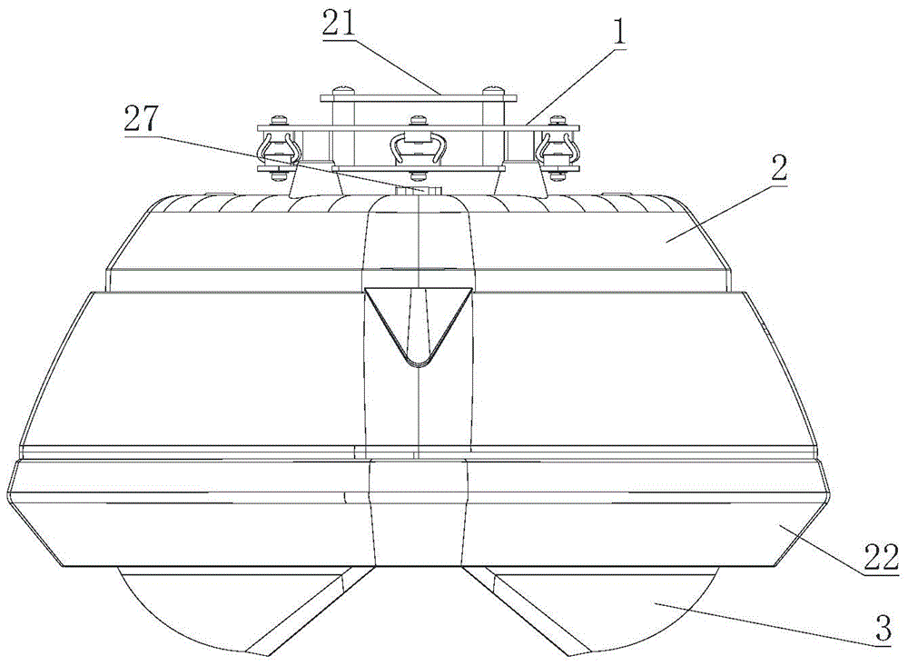
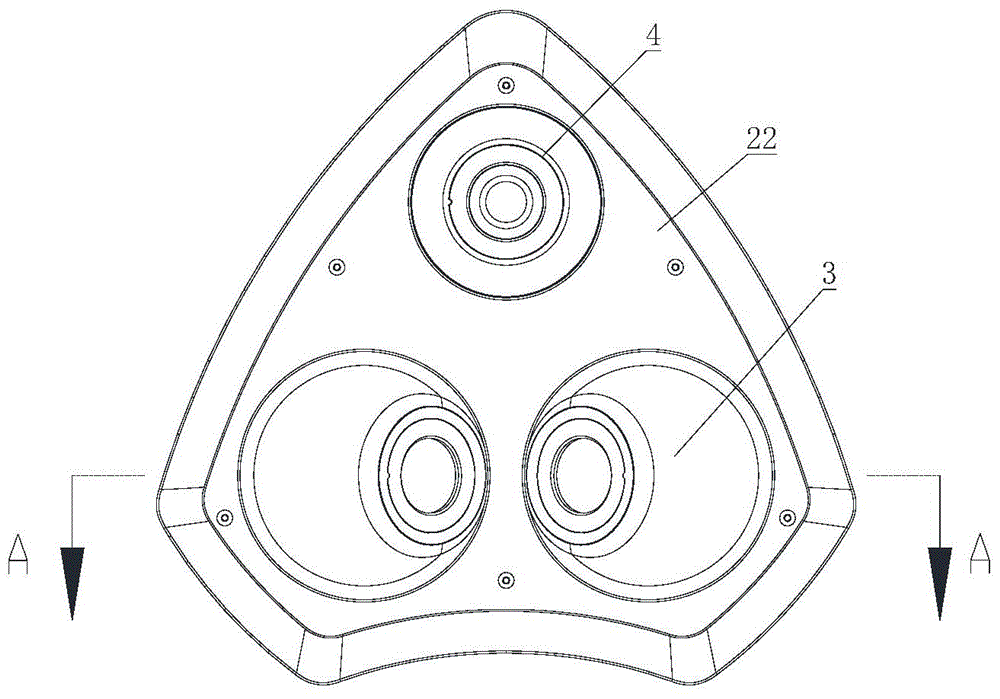
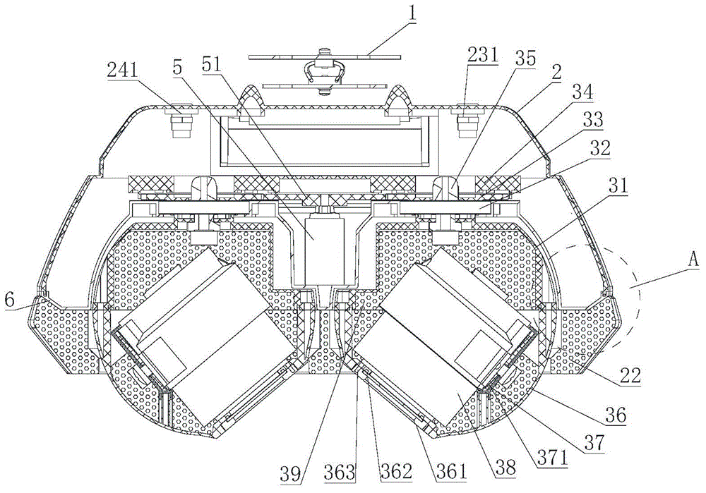
[0044] like Figure 1 to Figure 6As shown, the omni-directional aerial photography platform of the present invention includes an upper casing 2, a lower casing 6, a first camera 4 fixedly arranged in the lower casing, and a movable device below the lower casing 6. A rotating camera 3, a controller 7 for controlling the rotating camera 3 and the first camera 4, a driving mechanism for driving the rotating camera 3 to rotate along a horizontal plane; the visual axis direction of the first camera 4 is vertical down. The upper casing 2 and the lower casing 6 form a cavity for installing the controller 7 and the driving mechanism.

[0045] The controller 7 is used to r...


PUM

PropertyMeasurementUnit
Angleaaaaaaaaaa

Abstract

The invention discloses an aerial cloud platform for shooting in all directions. The aerial cloud platform comprises a casing, a camera group and a controller used for controlling the operation of the camera group, wherein the camera group comprises a first camera fixedly mounted in the casing, more than one rotary camera movably arranged below the casing, and a driving mechanism used for driving the rotary cameras to rotate along a horizontal plane; the optical axis direction of the first camera is vertically downward; each rotary camera comprises a camera casing, and a second camera obliquely arranged in the camera casing; a shooting hole corresponding to the lens of the second camera is formed in the camera casing; the optical axis direction of the second camera is vertically downward and forms an included angle with the optical axis direction of the first camera; the driving mechanism comprises a motor, and a transmission mechanism connected with the motor and the rotary cameras. The aerial cloud platform has a simple structure, can flexibly control the shooting angle of the second camera, has good anti-vibration property, guarantees the shooting quality, and is good in leakproofness, waterproof and dustproof, and compact in structure.

Description

technical field [0001] The invention belongs to the technical field of aerial photography platforms, and in particular relates to an aerial photography platform for omnidirectional shooting. Background technique [0002] UAV low-altitude remote sensing system is developing into the special field of photogrammetry and stereo mapping on the basis of realizing image map production. Oblique photography technology is a high-tech developed in the field of international surveying and mapping in recent years. It subverts the previous limitation that orthophoto images can only be taken from vertical angles. By carrying multiple sensors on the same flight platform and collecting images from one vertical, four oblique and five different angles at the same time, it introduces users to the The real and intuitive world of human vision. Aerial oblique images can not only truly reflect the situation of ground objects, but also can embed precise geographic information, richer image informa...

Claims


Application Information

Patent Timeline
IPC IPC(8): B64D47/08G03B17/56
Inventor 徐鹏
Owner GUANGZHOU REDBIRD HELICOPTER REMOTE SENSING TECH
Why Eureka
Try Eureka