Remote-sensing image coastline extracting method based on information vector machine

An information vector machine and remote sensing image technology, which is applied to computer components, instruments, character and pattern recognition, etc., can solve the problems of low precision and low efficiency of coastline extraction

Inactive Publication Date: 2015-06-24
GUANGXI UNIV
View PDF3 Cites 34 Cited by
  • Summary
  • Abstract
  • Description
  • Claims
  • Application Information

AI Technical Summary

Problems solved by technology

[0006] The purpose of the present invention is to provide a remote sensing image coastline extraction method based on in...

Method used


Image

  • Remote-sensing image coastline extracting method based on information vector machine
  • Remote-sensing image coastline extracting method based on information vector machine
  • Remote-sensing image coastline extracting method based on information vector machine

Examples


Embodiment Construction

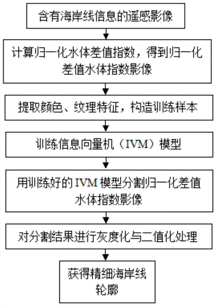
[0040] The present invention will be described in detail below in combination with specific embodiments. Such as figure 1 Shown is the flow of steps of the technical solution of the present invention. The present invention carries out according to the following steps:

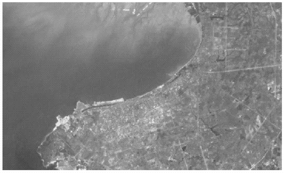
[0041] Step 1) Obtain the TM images of Beihai City, Guangxi and its nearby sea areas, and perform preprocessing such as band combination, geometric correction, and cropping in the remote sensing image processing software ERDAS IMAGINE 9.0, and obtain the remote sensing images containing coastline information to be extracted ( figure 2 ).

[0042] The band combination adopts TM4, 3, 2 (TM4 is near-infrared band, TM3 is red band, TM2 is green band) standard false color combination. Band combination, geometric correction, and cropping are all completed in the remote sensing image processing software ERDAS IMAGINE 9.0, and the specific implementation methods are well known to those skilled in the art. The imag...


PUM


Abstract

The invention discloses a remote-sensing image coastline extracting method based on an information vector machine. The remote-sensing image coastline extracting method includes the steps of firstly obtaining a remote-sensing image containing coastline information, calculating the normalization difference water body index according to wave band information of the remote-sensing image, and obtaining a NDWI image; then selecting sample points on the NDWI image, extracting the color characteristics, the textural characteristics and the types to construct a training sample, and training an IVM model; then automatically classifying all pixels of the image through the trained IVM model, and partitioning seawater from land of the remote-sensing image; finally extracting a coastline with the graying and binarization image processing technology. The remote-sensing image coastline extracting method has the advantages that the coastline extracting accuracy under noise pollution is remarkably improved, the coastline is rapidly and accurately extracted, and an efficient technological means is provided for measuring, identifying and analyzing the coastline.

Description

technical field [0001] The invention belongs to the technical field of remote sensing image coastline extraction, and relates to an information vector machine-based remote sensing image coastline extraction method. Background technique [0002] The coastline is the baseline for dividing ocean and land management areas. It is an important content for human to study the interaction between land and sea, the impact of sea-use activities on the coastal zone, the integrated management of the coastal zone and the ecosystem of the near-shore marine area. Its changes directly change the intertidal tidal zone The amount of resources and the environment of the coastal zone affect the survival and development of the people, so it is of great significance to quickly and accurately monitor the dynamic changes of the coastline. [0003] The more common method of traditional coastline extraction is to use manual field GPS measurement, but this method is time-consuming, laborious, inefficie...

Claims


Application Information

Patent Timeline
IPC IPC(8): G06K9/00G06K9/62
Inventor 苏国韶胡小川翟少彬尹宏雪赵盈胡李华彭立峰
Owner GUANGXI UNIV
Why Eureka
Try Eureka