Rendering method and device of three-dimensional space data

A three-dimensional space and data technology, applied in the field of communication, can solve the problems of unfavorable large-scale automatic operation, low data production accuracy, increase the complexity of model production uncertainties and data production, so as to ensure the accuracy of data display and reduce the complexity degree, eliminating the effect of manual intervention

Active Publication Date: 2015-07-08
TENCENT TECH (SHENZHEN) CO LTD +1
View PDF3 Cites 17 Cited by
  • Summary
  • Abstract
  • Description
  • Claims
  • Application Information

AI Technical Summary

Problems solved by technology

[0004] In the process of research and practice of the prior art, the inventors of the present invention have found that this method increases the uncertainty factors of model making an

Method used


Image

  • Rendering method and device of three-dimensional space data
  • Rendering method and device of three-dimensional space data
  • Rendering method and device of three-dimensional space data

Examples


no. 1 example

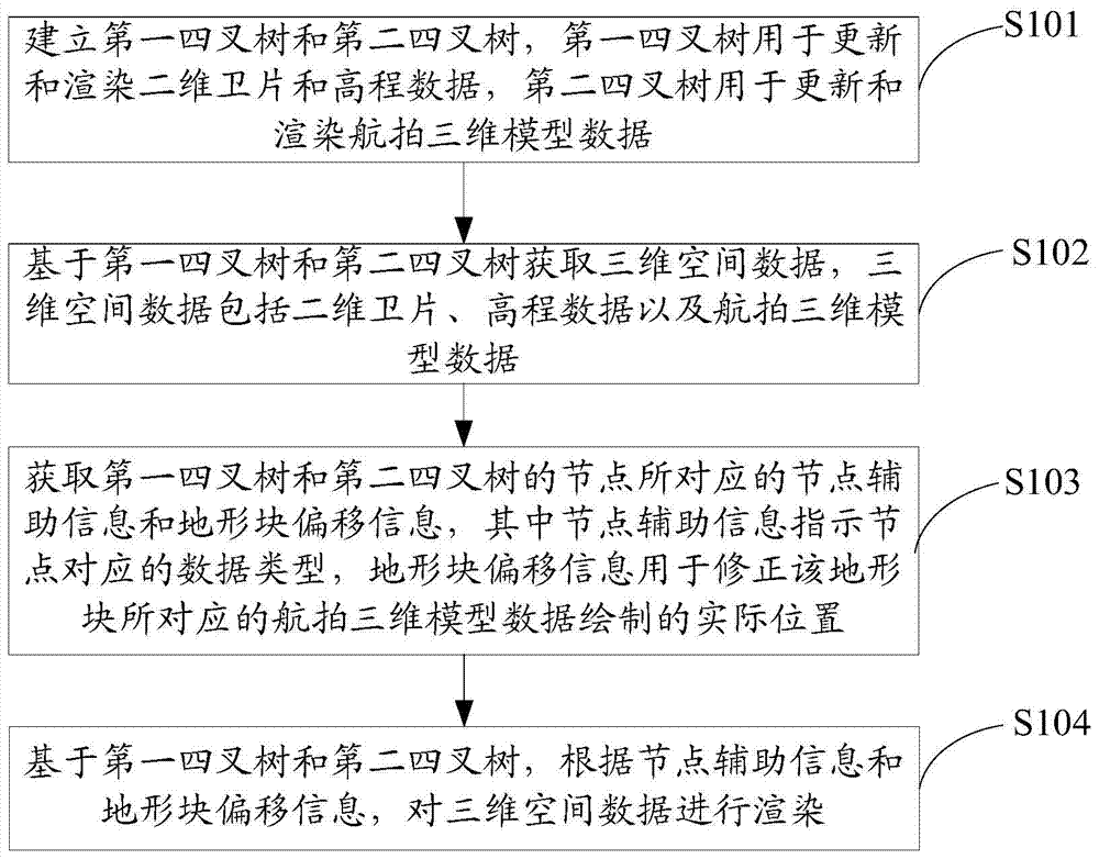
[0035] see figure 1 , figure 1 It is a schematic flowchart of the three-dimensional spatial data rendering method provided by the first embodiment of the present invention. The methods include:

[0036] In step S101, a first quadtree and a second quadtree are established, the first quadtree is used for updating and rendering two-dimensional satellite image and elevation data, and the second quadtree is used for updating and rendering Aerial 3D model data.

[0037]In step S102, three-dimensional space data is obtained based on the first quadtree and the second quadtree, and the three-dimensional space data includes two-dimensional satellite images, elevation data and aerial three-dimensional model data.

[0038] Wherein, the steps S101 and S102 may specifically be:

[0039] It can be understood that the rendering method of the three-dimensional space data can be based on running on a server, establishing the first quadtree and the second quadtree, and setting the first quad...

no. 2 example

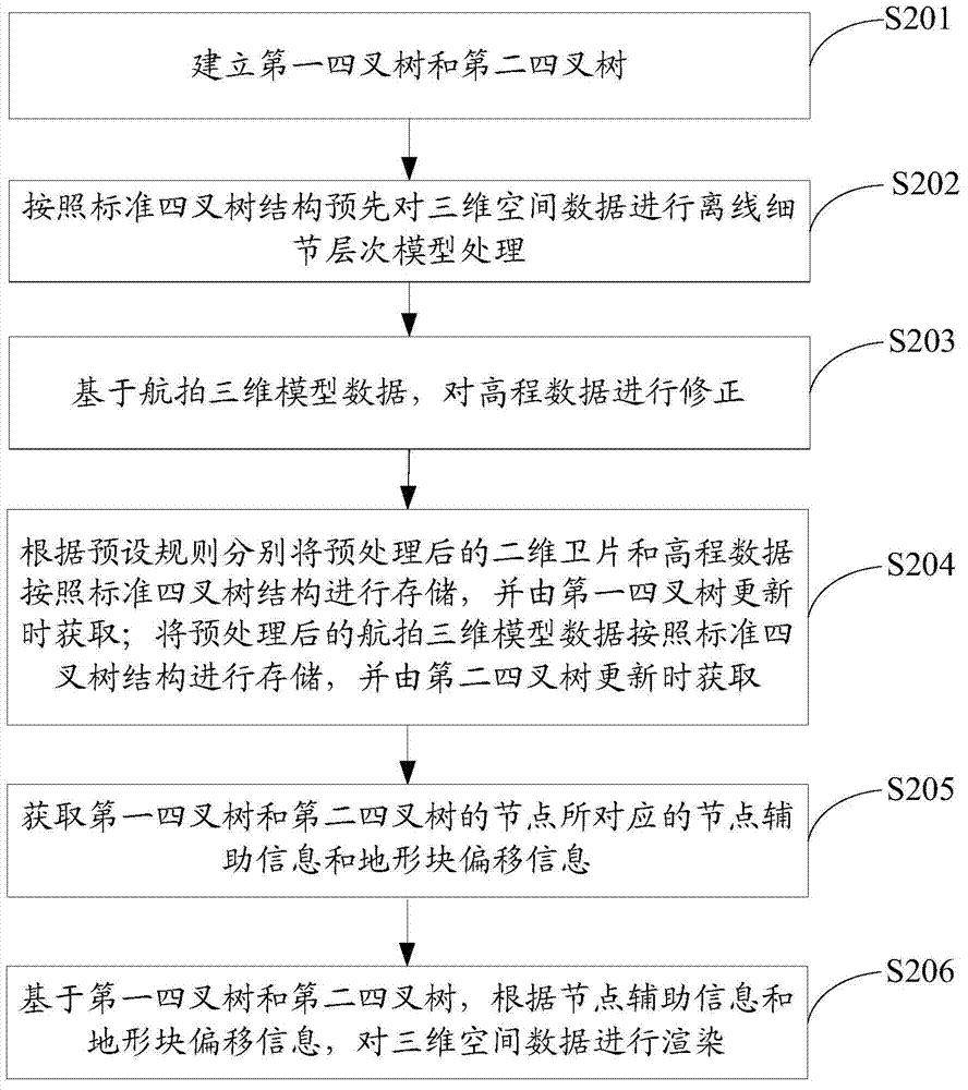
[0049] see Figure 2a , Figure 2a It is a schematic flowchart of a rendering method for three-dimensional spatial data provided by the second embodiment of the present invention. Wherein, the rendering method of the three-dimensional spatial data is based on running on a server, establishing the first quadtree and the second quadtree, and setting the first quadtree to be responsible for updating and rendering the two-dimensional satellite image and elevation data. In the three-dimensional earth space, the second quadtree is specially responsible for updating and rendering the aerial photography 3D model data; in the case of double quadtrees, two trees are used to update and draw in parallel, independent of each other, so that the aerial photography 3D model data can be superimposed Simultaneously draw on the 2D satellite image and elevation data deflected by coordinate encryption.

[0050] Different from the first embodiment, this embodiment mainly describes in detail the p...

no. 3 example

[0069] see Figure 3a , Figure 3a It is a schematic flow chart of the three-dimensional spatial data rendering method provided by the third embodiment of the present invention. Same as the above-mentioned embodiment, the rendering method of the three-dimensional spatial data is based on running on a server, establishes the first quadtree and the second quadtree, and sets the first quadtree to be responsible for updating and rendering the two-dimensional satellite image and In the three-dimensional earth space composed of elevation data, the second quadtree is responsible for updating and rendering the aerial photography 3D model data; in the case of double quadtrees, two trees are used to update and draw in parallel, independent of each other, making the aerial photography 3D model The data can be superimposed on the two-dimensional satellite image and elevation data after coordinate encryption and deflection, and draw simultaneously.

[0070] Different from the second embo...


PUM


Abstract

The invention discloses a rendering method and device of three-dimensional space data. The method includes the steps that the three-dimensional space data are obtained; a first quadtree for updating and rendering two-dimensional satellite images and altitude data is set, and a second quadtree for updating and rendering aerial photo three-dimensional model data is set; node auxiliary information and terrain block offset information corresponding to nodes of the two quadtrees are obtained, the three-dimensional space data are rendered according to the node auxiliary information and the terrain block offset information, the node auxiliary information indicates data types corresponding to the nodes, and the terrain block offset information is used for correcting drawn practical positions of the aerial photo three-dimensional model data corresponding to the terrain blocks. According to the method, updating and drawing are conducted simultaneously through the two quadtrees, the two quadtrees are independent from each other, so the aerial photo three-dimensional model data can be overlapped on the two-dimensional satellite images and the altitude which are subjected to data coordinate encryption deflection to be drawn at the same time; accordingly, in the scene transition and splicing process of a three-dimensional electronic map, manual intervention is eliminated, and uncertain factors of model making and the complexity of data making are reduced on the premise of guaranteeing data display accuracy.

Description

technical field [0001] The invention belongs to the technical field of communications, and in particular relates to a rendering method and device for three-dimensional spatial data. Background technique [0002] With the rapid development of computer graphics, three-dimensional simulation technology and virtual reality technology, the traditional two-dimensional electronic map has been injected with new vitality, and the three-dimensional electronic map carried on the Internet is becoming an important direction of electronic map development. [0003] At present, the general practice of 3D electronic maps is to construct a 3D earth space based on satellite images and elevation data in 2D electronic maps, and then superimpose or replace the 3D model data on this basis. This is especially true for electronic maps, where a scene transition and splicing problem is involved. Due to the consideration of national security, in order to prevent the leakage of basic geographic informa...

Claims


Application Information

Patent Timeline
IPC IPC(8): G06T15/00G06T17/00
Inventor 付玉锦吴伟李成军
Owner TENCENT TECH (SHENZHEN) CO LTD
Why Eureka
Try Eureka