
Urban fire disaster monitoring system based on the Internet of Things architecture and WebGIS

A monitoring system and Internet of Things technology, applied in transmission systems, fire alarms, instruments, etc., can solve the problems of inaccurate buildings, unfavorable targeted prevention, and large coverage, and achieve low power consumption, system cost and expansion Low time, adaptable effect

Inactive Publication Date: 2015-07-08
HOHAI UNIV
View PDF4 Cites 15 Cited by
  • Summary
  • Abstract
  • Description
  • Claims
  • Application Information

AI Technical Summary

Problems solved by technology

[0003] The existing urban fire danger level model is based on the city as the unit of forecast, which covers a large area and cannot be accurate to specific buildings. The prediction effect is small, which is not conducive to carrying out specific targeted prevention work

Method used


Image

  • Urban fire disaster monitoring system based on the Internet of Things architecture and WebGIS
  • Urban fire disaster monitoring system based on the Internet of Things architecture and WebGIS
  • Urban fire disaster monitoring system based on the Internet of Things architecture and WebGIS

Examples


Embodiment Construction

[0025] A kind of urban fire monitoring system based on the Internet of Things architecture and WebGIS provided by the present invention will be further described below in conjunction with the accompanying drawings.

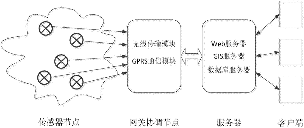
[0026] The system structure block diagram of the present invention is as figure 1 As shown, it includes four parts: sensor node, gateway coordinating node, WebGIS server and network client.

[0027] The sensor node includes a digital temperature and humidity sensor and a wireless transmission module, which is used to measure the temperature and humidity data and add the location information indicated by the short address to send to the gateway coordinating node. Sensor nodes can also act as routing nodes for other nodes to forward data, expanding the coverage of sensor nodes. The sensor nodes can be arranged in residential corridors, factory buildings, school teaching buildings, shopping malls and other buildings, and the number of nodes can be set according to t...


PUM


Abstract

The invention discloses an urban fire disaster monitoring system based on the Internet of Things architecture and the WebGIS, and belongs to the field of environmental monitoring. The urban fire disaster monitoring system comprises a sensor node, a gateway coordinating node, a server and a client side. The sensor node comprises a humiture sensor and a wireless transmission module, and is used for measuring humiture data and sending the data to the gateway coordinating node, or is regarded as a routing node to forward the data. The gateway coordinating node comprises a wireless transmission module and a GPRS communication module, and is used for receiving and analyzing data of a child node and sending the data to the server. The server comprises a Web server, a GIS server and a database server, and is used for analyzing and processing the data of the sensor and generating an urban fire risk level model map which comprises a fire risk level and positional information. The client side is used for remote detection, prevention and positioning on fire risk data, setting of remote parameters and the like. The system construction cost is low, network nodes can be rapidly expanded, and remote monitoring, predicting and positioning on urban fire disasters of different areas in a network are achieved.

Description

technical field [0001] The invention relates to an urban fire monitoring system based on the Internet of Things framework and WebGIS, belonging to the field of environmental monitoring. Background technique [0002] Urban fires are different from forest fires. Factors such as complex terrain, high-rise buildings and public facilities, dense population, and traffic congestion often make it difficult for people to escape and rescue in the event of urban fires, resulting in casualties and huge economic losses. There are many reasons for the occurrence of urban fires, and the main reasons can be roughly divided into natural reasons and human-made reasons. Natural causes are difficult to prevent, and are mostly caused by natural disasters such as lightning. Only certain technical means can be used to monitor and improve the protection of fire-prone areas; while fires caused by human factors are mostly caused by long-term lack of maintenance of circuits and violations of safety by...

Claims


Application Information

Patent Timeline
IPC IPC(8): H04L29/08
CPCG08B17/00H04L67/12
Inventor 李昌利王清云
Owner HOHAI UNIV
Learn More