Atmospheric pollution data acquisition method for industrial park based on unmanned aerial vehicle

A technology for data collection and air pollution, applied in the field of atmospheric environment science, can solve the problems of not taking into account the constraints of coverage and time, collecting data is not comprehensive enough, and the data collection process is not scientific and reasonable.

Inactive Publication Date: 2015-08-26
SHANGHAI JIAO TONG UNIV
View PDF10 Cites 34 Cited by
  • Summary
  • Abstract
  • Description
  • Claims
  • Application Information

AI Technical Summary

Problems solved by technology

However, this technology does not take into account the constraints of drone flight coverage and time, and cannot take into account the emission contributions of different pollution sources and...

Method used


Image

  • Atmospheric pollution data acquisition method for industrial park based on unmanned aerial vehicle
  • Atmospheric pollution data acquisition method for industrial park based on unmanned aerial vehicle
  • Atmospheric pollution data acquisition method for industrial park based on unmanned aerial vehicle

Examples


Embodiment 1

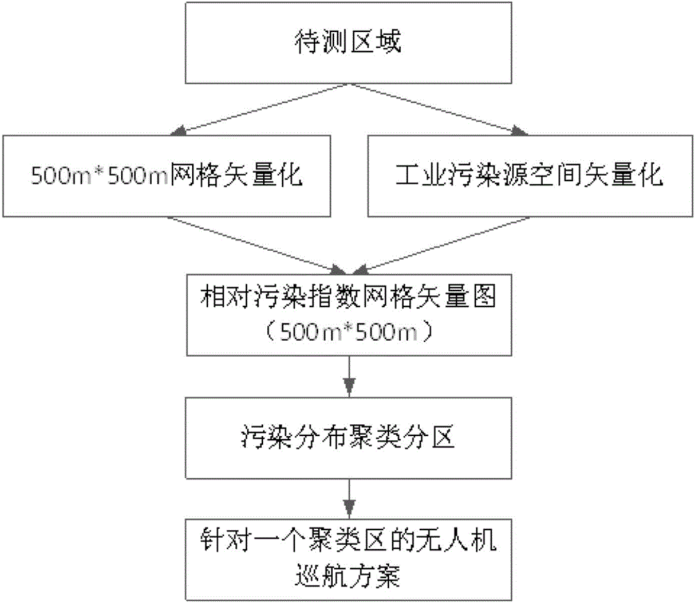
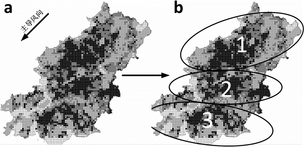
[0030] Such as figure 1 As shown, this embodiment includes: 1) regular grid vectorization of the area to be measured, 2) spatial vectorization of industrial pollution sources, 3) calculation of the relative pollution index of the grid unit, 4) pollution clustering division of the area to be measured, 5) Develop a drone cruise plan for each pollution cluster area.

[0031] This embodiment specifically includes the following steps:

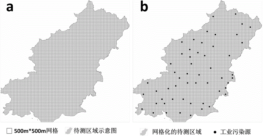
[0032] 1) Regular grid vectorization of the area to be measured. Such as figure 2 As shown in a, the area to be measured is uniformly gridded, and the grid unit is set to 500m*500m regular polygon elements. The specific steps include: first obtain the vector map of the area to be measured containing the projected coordinate system (unit: Meter), and then Use the Fishnet tool in the ArcMap platform to generate a 500m*500m grid vector map covering the entire area to be tested.

[0033] 2) Spatial vectorization of industrial pollution sources. Perform a ...


PUM


Abstract

The invention discloses an atmospheric pollution data acquisition method for an industrial park based on an unmanned aerial vehicle. The atmospheric pollution data acquisition method comprises the following steps: performing grid distribution on zones to be tested and pollution sources; setting that the influence of the pollution sources on the adjacent zones is inversely proportional to a distance, and considering the importance of the pollution sources and the influence of seasonal wind directions; calculating the relative pollution index of each of the pollution sources to each grid unit, and further dividing the zones to be tested into a plurality of pollution gathering zones; making a cruise plan of the unmanned aerial vehicle for each pollution zone, wherein the unmanned aerial vehicle carries a portable detector, and automatically cruises from the leeward boundary of the flight area to the upper boundary in an S-shaped trace; enabling the acquired pollutant data to perform association in time with the GPS positioning data of the unmanned aerial vehicle; matching the pollutant monitoring data with a grid vector map of the zone to be tested; taking the average value of all pollutant sample data in each unit grid as the final value of the unit grid. Through the adoption of the atmospheric pollution data acquisition method disclosed by the invention, the data acquisition is more optimal and scientific, and convenient for environment management and decision making.

Description

Technical field [0001] The invention relates to a technology in the field of atmospheric environment science, in particular to a method for collecting air pollution data in an industrial park based on a drone. Background technique [0002] Industrialization has promoted the rapid growth of society and economy, and at the same time it has also brought about increasingly severe air pollution problems. Taking urban industrial parks as an example, environmental problems such as malodorous gas pollution are increasingly being complained by surrounding residents, which has become a bottleneck problem in the development of the park. At present, sparse ground monitoring stations can no longer monitor the air pollution in the park in an all-round way, and it is difficult to measure the impact of complex and scattered pollution sources on the surrounding area, which makes it impossible to scientifically and reasonably evaluate the air pollution status in the park, which makes it impossible...

Claims


Application Information

Patent Timeline
IPC IPC(8): G01N33/00
Inventor 彭仲仁王占永王东生柏丛路庆昌高雅
Owner SHANGHAI JIAO TONG UNIV
Why Eureka
Try Eureka