Satellite remote sensing data order service system

A satellite remote sensing data and service system technology, which is applied in the field of satellite remote sensing data ordering service system, can solve problems such as inability to modify and limit user needs, and achieve high flexibility and convenience

Inactive Publication Date: 2015-09-23
INST OF REMOTE SENSING & DIGITAL EARTH CHINESE ACADEMY OF SCI +1
View PDF0 Cites 13 Cited by
  • Summary
  • Abstract
  • Description
  • Claims
  • Application Information

AI Technical Summary

Problems solved by technology

[0003] The current satellite remote sensing data service system mainly includes two parts: user management and product query. After the user logs in to the system, the user can only query the produced data products in the designated area. The product area and preprocessing method have been determined and cannot be m...

Method used


Image

  • Satellite remote sensing data order service system
  • Satellite remote sensing data order service system
  • Satellite remote sensing data order service system

Examples


Embodiment Construction

[0026] In order to make the object, technical solution and advantages of the present invention clearer, the present invention will be further described in detail below in conjunction with specific embodiments and with reference to the accompanying drawings.

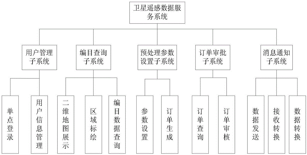
[0027] The logical relationship of the satellite remote sensing data ordering service system of the present invention is as follows: figure 1 As shown, the satellite remote sensing data service system includes: user management subsystem, catalog query subsystem, preprocessing parameter setting subsystem, order approval subsystem and message notification subsystem, and each component will be described in detail below.

[0028] (1) User management subsystem

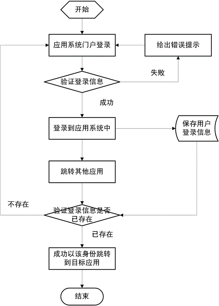
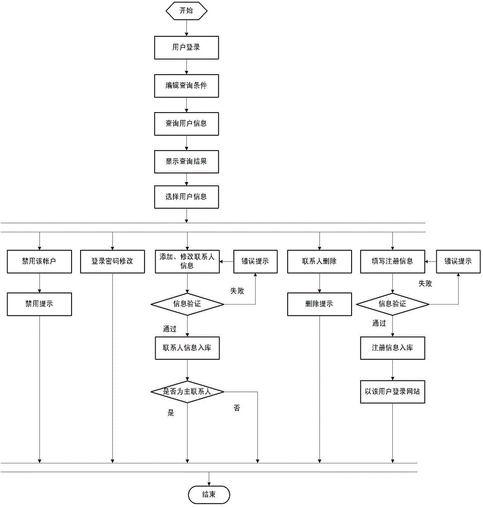
[0029] The user management subsystem consists of two parts: single sign-on and user information management. Single sign-on is used to provide a unified portal framework, and each application software attached to the portal framework realizes the seamless connection amo...


PUM


Abstract

The invention discloses a satellite remote sensing data order service system. The satellite remote sensing data order service system comprises a user management subsystem, a catalogue query subsystem, a pretreatment parameter setting subsystem, an order approval subsystem, and a message notification subsystem. According to the order service system, the order data area can be flexibly selected, the selecting method includes: administrative division, polygonal area, Shp file, satellite sensor selection, and time quantum, pre-processed parameters of configuration data can be defined by users, and the remote sensing data order service system capable of flexibly selecting the preprocessed parameters is provided.

Description

technical field [0001] The invention relates to the field of remote sensing information processing, and more particularly relates to a satellite remote sensing data ordering service system, which can provide an ordering service supporting preprocessing settings under the conditions of various satellites, sensors and working modes. Background technique [0002] Satellite data are now playing an increasingly important role in various fields. The satellite data reception management system receives the remote sensing data downloaded from various satellites, catalogs and processes the remote sensing data, and obtains the cataloged data. The satellite remote sensing data service system can preprocess the catalog data according to the needs of different users, and provide products to users. The current satellite remote sensing data service system can provide processing and application services for the data of the LandSat series of the United States, the SPOT series of France, the ...

Claims


Application Information

Patent Timeline
IPC IPC(8): G06Q30/06
Inventor 周彤章文毅冯阳黄鹏崔庆丰陈金勇冯柯过西荣马广彬颜博孔庆玲厉为裴艳峰卢明方王伟星
Owner INST OF REMOTE SENSING & DIGITAL EARTH CHINESE ACADEMY OF SCI
Why Eureka
Try Eureka