
A tourist location positioning communication management system and positioning communication management method

A technology of geographic location positioning and geographic location information, which is applied in the direction of location-based information-based services, near-field transmission systems using transceivers, and comprehensive factory control. , raise the voice and other issues, to reduce potential safety hazards, standardize tour behavior, and reduce mutual interference

Active Publication Date: 2018-12-28
天津智博源科技发展有限公司
View PDF4 Cites 0 Cited by
  • Summary
  • Abstract
  • Description
  • Claims
  • Application Information

AI Technical Summary

Problems solved by technology

However, when the distance is too far, it is difficult to find the tour guide because the people are scattered and cannot hear the call, or the tourists do not have a mobile phone or the mobile phone is out of battery, which may delay the tour of the whole group. Unable to determine the specific location and find the correct route due to unfamiliarity with the environment, this also brings objective difficulties for tourists to return to the group smoothly
In addition, with the development of the tourism industry, there are now a large number of tourists in various scenic spots, and multiple tour guides explaining at one scenic spot at the same time cannot give directional explanations, so they have to raise their voices or even use tweeters, resulting in noise pollution and reducing the tourist environment of the scenic spot and tourist experience
In addition, the existing tour group management methods cannot monitor and manage potential safety accidents caused by tourists maliciously leaving the group. When an emergency occurs, such as earthquakes and other natural disasters, the existing management system cannot provide assistance for tourist rescue

Method used


Image

  • A tourist location positioning communication management system and positioning communication management method

Examples


Embodiment Construction

[0024] In order to further understand the content of the invention, characteristics and effects of the present invention, the following examples are described in detail as follows:

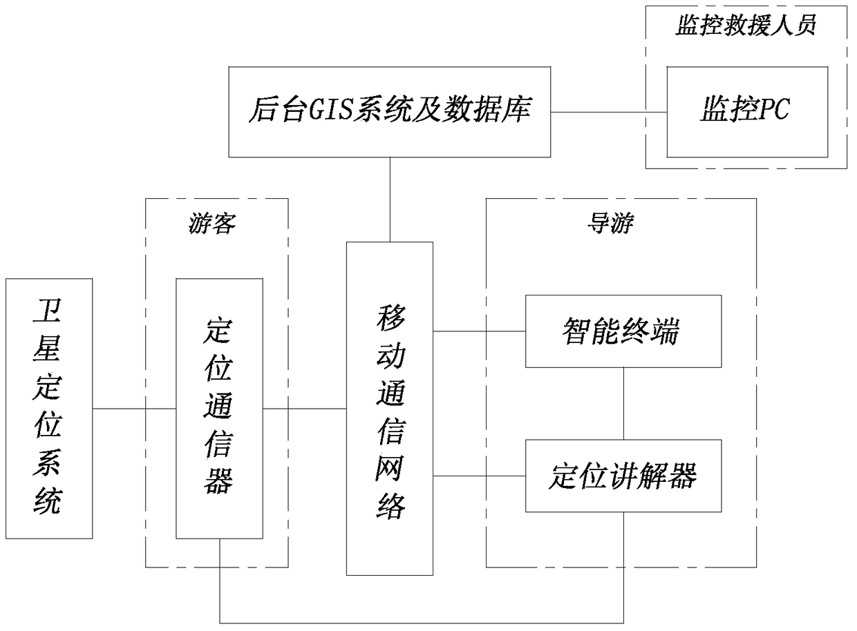
[0025] See figure 1 , the present invention includes a mobile communication network, a positioning communicator held by tourists, an intelligent terminal held by a tour guide, a positioning explainer, a background GIS system and a database, and a monitoring PC held by supervisory rescuers. in,

[0026] The positioning communicator held by the tourists is carried by the tourists after the tour group is formed, and the structure includes a positioning module, a communication module, a bluetooth module and a voice module. The positioning module obtains the current geographic location information from the satellite positioning system, where the geographic location information can be selected as longitude and latitude data information; the communication module sends and Receive data, these data can i...


PUM


Abstract

The invention relates to a tourist geographical location positioning communication management system. It includes mobile communication networks, positioning communicators held by tourists, smart terminals and positioning guides held by tour guides, background GIS systems and databases, and monitoring PCs held by supervisory and rescue personnel; the positioning communicator uses a positioning module to obtain the current geographical location. , the communication module is used to transmit data with the intelligent terminal and the background GIS system and database, and the Bluetooth module is used to exchange data with the positioning interpreter; the intelligent terminal transmits data with the positioning communicator and the background GIS system and database; the positioning interpreter obtains the current geographical location information, The communication module is used to send and receive data to the smart terminal and the back-end GIS system and database; the back-end GIS system and database receive the returned geographical location information and perform visual positioning; the monitoring PC retrieves the tourist's geographical location information from the back-end GIS system and database Monitor. The invention also relates to a tourist geographical location positioning communication management method.

Description

technical field [0001] The invention relates to a tourist location positioning communication management system and a positioning communication management method. Background technique [0002] When tourists get lost or lose contact with the group when they are traveling with a group, the tour guide can only contact the tourists by shouting or calling and regulate the tourists' tour behavior. However, when the distance is too far, it is difficult to find the tour guide because the people are scattered and cannot hear the call, or the tourists do not have a mobile phone or the mobile phone is out of battery, which may delay the tour of the whole group. Due to unfamiliarity with the environment, it is impossible to determine the specific location and find the correct route, which also brings objective difficulties for tourists to return to the group smoothly. In addition, with the development of the tourism industry, there are now a large number of tourists in various scenic sp...

Claims


Application Information

Patent Timeline
Patent Type & Authority Patents(China)
IPC IPC(8): H04W4/02H04W4/06H04B5/02G05B19/418H04B5/48
CPCH04W4/022H04W4/026H04W4/06G05B19/4185H04B5/48Y02P90/02
Inventor 贺晓龙
Owner 天津智博源科技发展有限公司
Learn More