
Low-cost GPS and INS integrated navigation system for multi-rotor aircrafts

A multi-rotor aircraft and integrated navigation system technology, applied in the field of integrated navigation, can solve the problems of high cost and poor accuracy of navigation system

Inactive Publication Date: 2015-11-04
UNIV OF ELECTRONICS SCI & TECH OF CHINA
View PDF9 Cites 26 Cited by
  • Summary
  • Abstract
  • Description
  • Claims
  • Application Information

AI Technical Summary

Problems solved by technology

[0005] The purpose of the present invention is to solve the problems of poor accuracy or high cost of existing navigation systems

Method used


Image

  • Low-cost GPS and INS integrated navigation system for multi-rotor aircrafts
  • Low-cost GPS and INS integrated navigation system for multi-rotor aircrafts
  • Low-cost GPS and INS integrated navigation system for multi-rotor aircrafts

Examples


Embodiment Construction

[0040] The present invention will be described in detail below in combination with specific embodiments.

[0041]The integrated navigation system of the present invention is designed for multi-rotor aircraft, and the most common type of multi-rotor aircraft is a quad-rotor aircraft (Quad-Rotor). Quadrotor aircraft, also known as quadcopter, is a vertical take-off and landing (VTOL) unmanned aircraft, and its derivatives also include multi-rotor aircraft such as six-axis, eight-axis or even sixteen-axis. This kind of aircraft is usually composed of mechanical structure, flight control and navigation system, power system, communication system and mission module, and can realize remote control or autonomous flight. Compared with fixed-wing UAVs, quadrocopters have the advantages of flexibility and hovering of rotor UAVs; compared with traditional rotor UAVs, quadrocopters have greater load, simpler mechanical structure and A more flexible way of flying.

[0042] hardware system...


PUM


Abstract

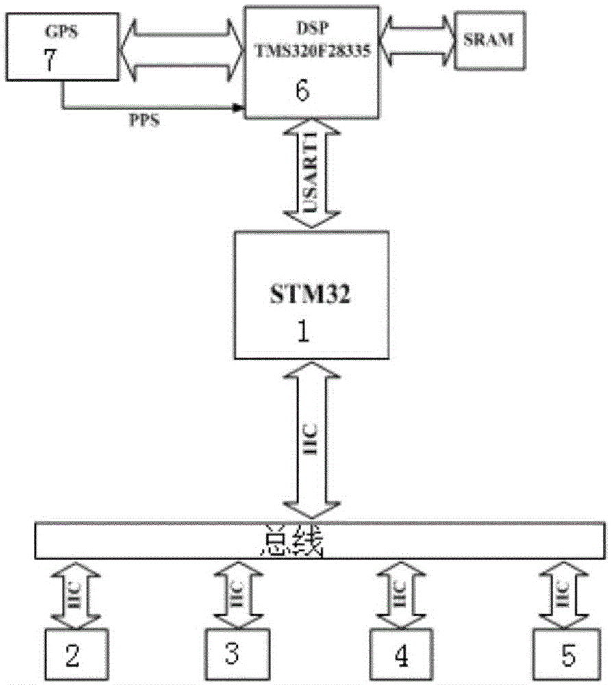
The present invention discloses a low-cost GPS and INS integrated navigation system for multi-rotor aircrafts. The system includes a data acquisition processor; the data acquisition processor is respectively connected to a gyroscope, an accelerometer, a magnetometer and a barometer via an IIC bus; the data acquisition processor controls the gyroscope, accelerometer, magnetometer, and barometer for data collection, and sends the collected sensor data to a DSP controller; the GPS module sends the positioning data to the DSP controller; and the DSP controller conducts navigation calculation on the sensor data and location data. The invention has the beneficial effects that according to the dynamic characteristics of the multi-rotor aircraft and error characteristics of the low-cost sensor, the navigation system provides accurate attitude, speed and location information for the aircraft.

Description

technical field [0001] The invention belongs to the technical field of integrated navigation and relates to a low-cost integrated navigation system for multi-rotor aircraft based on the loose coupling mode of GPS and INS. Background technique [0002] Among the various existing navigation technologies, inertial navigation, satellite navigation and their combined navigation are the most widely used in current research and application. Inertial Navigation System (INS) is a three-dimensional dead reckoning (DR) navigation system based on classical physics theory, using inertial sensors and navigation computers to calculate the user's attitude angle, speed and position. The advantage of INS lies in its high-bandwidth navigation results and short-term accuracy. The disadvantage is that the error of INS will accumulate over time, and the price of INS with higher accuracy is also very expensive. The global navigation satellite system (GNSS) is a direct positioning system that is f...

Claims


Application Information

Patent Timeline
IPC IPC(8): G01C21/00G01C21/16G01S19/49
CPCG01C21/165G01S19/49
Inventor 白金平武俊兵李亚军张剑锋
Owner UNIV OF ELECTRONICS SCI & TECH OF CHINA
Learn More