Agricultural unmanned aircraft controlled by Beidou satellite and GPS (global positioning system)

A technology of unmanned aircraft and Beidou satellites, applied in aircraft parts, transportation and packaging, launch devices, etc., can solve problems such as crashes, loss of accurate control of unmanned aircraft, and achieve the effect of high navigation performance

Inactive Publication Date: 2015-11-11
胡茂东
View PDF0 Cites 23 Cited by
  • Summary
  • Abstract
  • Description
  • Claims
  • Application Information

AI Technical Summary

Problems solved by technology

However, for large-scale agricultural spraying, it is necessary to accurately locate the flight trajectory of the UAV, otherwise it will lead to the loss of accurate control of the UAV, and even cause a crash
Most of the current drones use a single navigation system. Since any single navigation system inevitably has its own shortcomings, only a single navigation system cannot meet the requirements of large-scale agricultural spraying on the accuracy of drone control.

Method used


Image

  • Agricultural unmanned aircraft controlled by Beidou satellite and GPS (global positioning system)

Examples


Embodiment Construction

[0018] The technical solutions in the present invention will be clearly and completely described below in conjunction with the accompanying drawings. Apparently, the described embodiments are only some of the embodiments of the present invention, not all of them. Based on the embodiments of the present invention, all other embodiments obtained by persons of ordinary skill in the art without making creative efforts belong to the protection scope of the present invention.

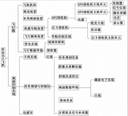
[0019] Such as figure 1 As shown, the application provides an agricultural unmanned aircraft controlled by Beidou satellite and GPS double star, the unmanned aircraft includes: an aircraft and a ground control system, and the ground control system includes a mission planning and control station, a power supply vehicle and an antenna system. The power supply vehicle is used to provide power for the ground control system, and the antenna system is used to receive signals emitted by the aircraft to realize two-...


PUM


Abstract

The invention discloses an agricultural unmanned aircraft controlled by a Beidou satellite and a GPS (global positioning system). The agricultural unmanned aircraft comprises an aircraft body and a ground control system, wherein the ground control system comprises a task planning and control station, a power supply cart and an antenna system; the aircraft body comprises an airplane body, a propelling device, a chemical spraying device, a flight manipulating device, a power supply system, an airplane-borne navigation device and a flight data terminal; the task planning and control station comprises a task planning device, a control and display control platform, an image and remote measuring facility, a computer, a signal processor, a ground data terminal and a communication device; the airplane-borne navigation device comprises a GPS receiver, a Beidou receiver and a navigation control system; the GPS receiver comprises a GPS receiver antenna unit, a GPS receiver host unit and a power supply; the Beidou receiver comprises a receiving antenna, a transmitter and a Beidou receiver host unit; the navigation control system is used for preprocessing the GPS navigation information and Beidou navigation information and uniformly changing a coordinate system and a datum point.

Description

technical field [0001] The invention relates to an agricultural unmanned aircraft controlled by a Beidou satellite and a GPS double star, and belongs to the intersecting field of satellite positioning and navigation technology and agricultural flying machine technology. Background technique [0002] With the development of science and technology, the traditional agricultural production mode is gradually replaced by mechanization and informationization. The use of drones for low-altitude operations has the characteristics of flexible use, small size, and low cost, which can greatly improve the efficiency of agricultural, forestry and plant protection flight operations. and precision. At present, the domestic unmanned light and small aircraft industry for agricultural use is in the research and preliminary trial stage, and my country's agricultural aviation technology is still in its infancy. [0003] Drones can provide detailed information in three areas in agriculture: Firs...

Claims


Application Information

Patent Timeline
Patent Type & Authority Applications(China)
IPC IPC(8): B64D43/00B64D1/18
Inventor 周俊胡茂东刘标
Owner 胡茂东
Why Eureka
Try Eureka