Atmospheric radar image interpolation method and device based on Fourier spectrum analysis

A technology of radar image and interpolation method, which is applied in measurement devices, climate sustainability, reflection/re-radiation of radio waves, etc. It can solve problems affecting radar data assimilation, disaster warning, and revealing strong convective weather.

Active Publication Date: 2015-11-18
NANJING UNIV OF INFORMATION SCI & TECH
View PDF4 Cites 5 Cited by
  • Summary
  • Abstract
  • Description
  • Claims
  • Application Information

AI Technical Summary

Problems solved by technology

This leads to the absence of some possible strong echo centers on the long-distance echo map. These strong echo centers cannot be displayed when making radar puzzles, which makes the echo appear

Method used


Image

  • Atmospheric radar image interpolation method and device based on Fourier spectrum analysis
  • Atmospheric radar image interpolation method and device based on Fourier spectrum analysis
  • Atmospheric radar image interpolation method and device based on Fourier spectrum analysis

Examples


Embodiment Construction

[0043] The present invention will be described in further detail in conjunction with the accompanying drawings and specific embodiments.

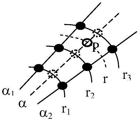
[0044] The essence of the method of the invention is to use Fourier spectral analysis to obtain the spectral features of the temporal and spatial variation of the echo intensity, further use the spectral features to fit the discrete points of the observation data, and then perform re-sampling. Therefore, it is beneficial to show some strong echo centers that cannot be detected due to the low resolution of the radar.

[0045]Fourier spectrum analysis is a commonly used method in data signal analysis. It uses frequency, amplitude and phase to describe the vibration waveform in the time domain or space domain, and then analyzes the laws and characteristics of the data. It has been widely used in meteorology. Applications. The present invention regards radar observation data as time series, as, on given radar observation direction, take Δt=1 l...


PUM


Abstract

The invention discloses an atmospheric radar image interpolation method and an atmospheric radar image interpolation device based on Fourier spectrum analysis, which obtain spectral characteristics of temporal and spatial variation of echo intensity by utilizing Fourier spectrum analysis, further apply the spectral characteristics to fit observation data discrete points, and then carry out resampling. The atmospheric radar image interpolation method can make structural characteristics of a strong echo region prominent when processing radar echo data with prominent strong echo center characteristics in a convection region, especially can interpolate an strong echo center which cannot be detected due to low radar resolution at a place far away from a radar, provides reference for further identifying position and intensity of the strong echo center accurately, can solidifying an algorithm program of the atmospheric radar image interpolation method into a chip so as to manufacture a chip device which is fast in operation speed and can satisfy real-time requirements.

Description

technical field [0001] The invention relates to an atmospheric radar image interpolation method and device based on Fourier spectrum analysis, and belongs to the technical field of weather radar image processing. Background technique [0002] The commonly used interpolation methods in weather radar network observation data processing are: 1) nearest neighbor method; 2) linear interpolation method; 3) Cressman weight method; 4) Barnes method or exponential weight method. The interpolation methods involved in the gridding of image data (often called PPI) obtained by radar observation at a given elevation angle are mainly the nearest neighbor method and bilinear interpolation method. Among them, the nearest neighbor method directly takes the observation value closest to the interpolation point, which takes the least time but has the least interpolation meaning; the bilinear interpolation method uses the distance as the weight to calculate the weighted average of the four observ...

Claims


Application Information

Patent Timeline
IPC IPC(8): G01S13/95
CPCG01S13/95Y02A90/10
Inventor 王振会焦鹏程朱艺青韩静楚志刚
Owner NANJING UNIV OF INFORMATION SCI & TECH
Why Eureka
Try Eureka