Method for processing open-type geological geographic information and system thereof

An information processing method and geographic information technology, applied in the open geological geographic information system processing method and its system field, can solve the problems of limited data volume, waste, and geological databases not open to the outside world, so as to achieve environmental protection and improve environmental protection. The degree of utilization and the effect of saving social resources

Inactive Publication Date: 2015-11-25
HENNAN ELECTRIC POWER SURVEY & DESIGN INST
View PDF4 Cites 6 Cited by
  • Summary
  • Abstract
  • Description
  • Claims
  • Application Information

AI Technical Summary

Problems solved by technology

[0003] At present, there are many large and small geological databases in various countries, industries, regions, and units, but there is still a large amount of basic geological data that has not been included. Users generally need to inquire and pu

Method used


Image

  • Method for processing open-type geological geographic information and system thereof

Examples


Embodiment Construction

[0020] The present invention will be described in further detail below in conjunction with the accompanying drawings and specific embodiments.

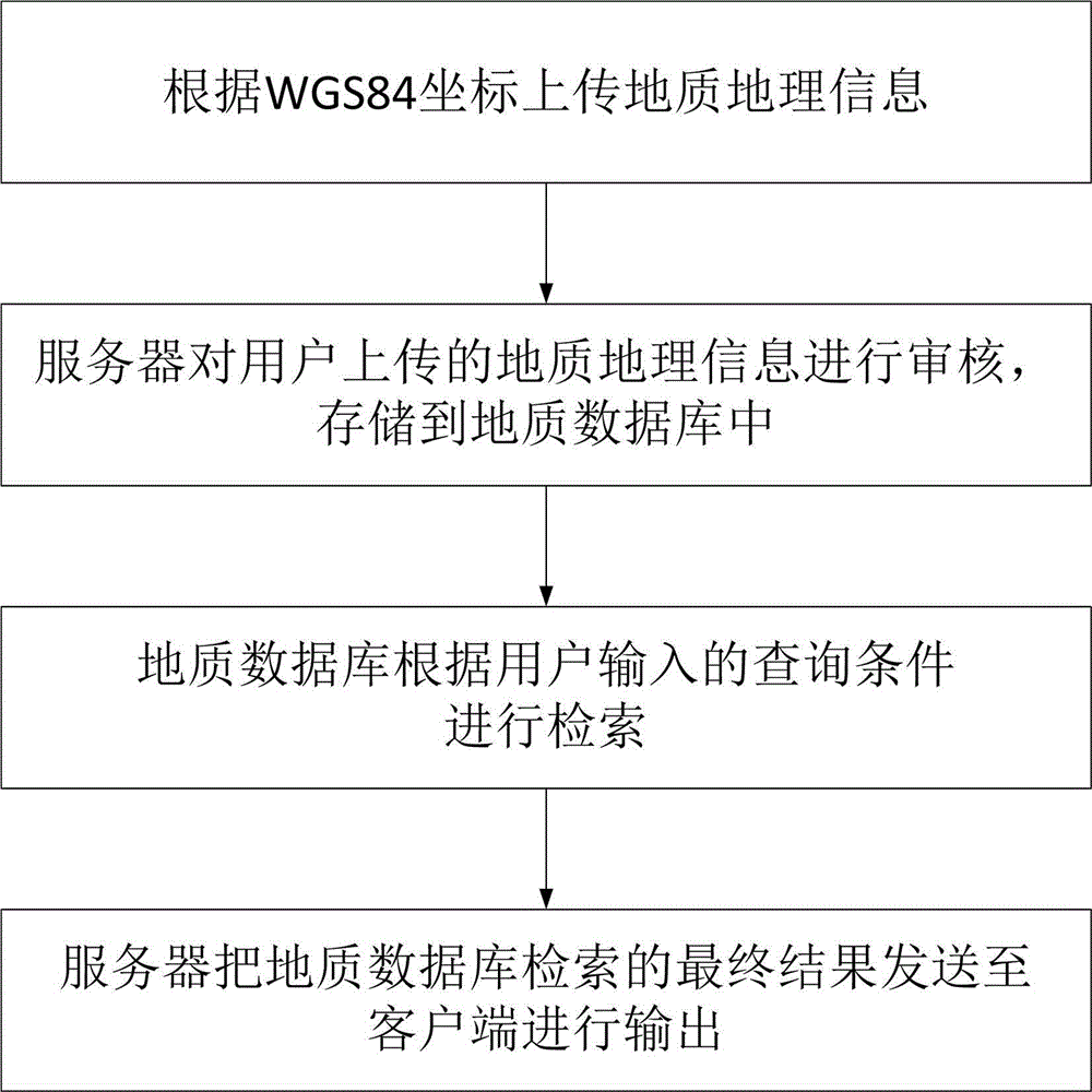
[0021] An open geological geographic information processing method is characterized in that it comprises the following steps:

[0022] A: The user marks the WGS84 coordinate position on the client, and uploads the geological and geographical information at the WGS84 coordinate position to the server.

[0023] The client uses a 3D globe that can be rotated arbitrarily as a user interface, similar to Google Earth. The upload of geological and geographic information is open. Geologists, survey units and scientific research institutes around the world can mark the coordinate position on the "3D Earth" according to the WGS84 coordinates, and upload various geological data, including the original data of engineering survey , technologically processed reconnaissance reports, and public geological data that are not confidential or involve in...


PUM


Abstract

The invention discloses a method for processing open-type geological geographic information, which comprises following steps: a. WGS84 coordinate position is marked on a client by a user and geological geographic information of the WGS84 coordinate position is uploaded to a server; b. the geological geographic information uploaded by the user is checked by the server and the geological geographic information is stored to a geological database; c. the geological database is used to research based on query conditions inputted by the user; d. and the final result researched by the geological database in c step is sent by the server to the client for output. The invention also discloses a system adopting the above method. By using the method and the system provided herein, based on the WGS84 coordinates, worldwide users can mark positions on the three-dimensional earth and upload various geological datum; and only need to browse the three-dimensional earth, worldwide users can research and download coordinates based on the WGS84 coordinates, thus the query and download are more convenient; the reusing degree of the geological datum is greatly enhanced; and not only the geological geographic information can be shared and the social resources are saved, but also the environment is conducive to be protected.

Description

technical field [0001] The invention relates to an information processing method, in particular to an open geological geographic information system processing method and its system. Background technique [0002] In the past century, with the construction of global infrastructure, the geological industry has achieved unprecedented development, and a large number of basic geological data have been preserved, including information on geology, engineering geology, seismic geology, environmental geology, and structural geology. . [0003] At present, there are many large and small geological databases in various countries, industries, regions, and units, but there is still a large amount of basic geological data that has not been included. Users generally need to inquire and purchase on-site, and the data volume is limited. The geological database is not open to the outside world, which seriously restricts the reuse of geological data. A large number of engineering survey work n...

Claims


Application Information

Patent Timeline
IPC IPC(8): G06F17/30
CPCG06F16/29
Inventor 张石友孙海建高首都张思军汪保明王宇张险峰王松江王庆环张中原王瑞来陈艳国李爱国刘明亮郭军辉张明赵自文
Owner HENNAN ELECTRIC POWER SURVEY & DESIGN INST
Why Eureka
Try Eureka