Geological disaster predication system

A technology for geological disasters and prediction systems, applied in instruments, alarms, etc., can solve problems such as low accuracy, failure to consider the relationship between precipitation and landslides and other geological disasters, and failure to realize early warning for end users, so as to achieve the effect of improving accuracy

Inactive Publication Date: 2015-11-25
XI'AN PETROLEUM UNIVERSITY
View PDF5 Cites 30 Cited by
  • Summary
  • Abstract
  • Description
  • Claims
  • Application Information

AI Technical Summary

Problems solved by technology

The current geological disaster early warning system integrates a variety of environmental data measurement components, and uses the communication network to transmit the data and images measured by the measurement components from the on-site monitoring device to the main monitoring device, and then transmit the monitoring information to the responsible unit to speed up the process. Disaster relief work, but the system cannot predict the precipitation in the monitoring area, monitor the quantitative displacement information of the monitoring area or objects in real time, and automatically warn according to the precipitable precipitation and spatial displacement information; at the same time, the system needs to install a large number of sensors, which is costly ; or use rainfall and infrared displacement sensors to transmit to the data center through the wireless network to monitor the actual rainfall intensity, rainfall duration, landslide and subsidence status information and dangerous rock sliding information of landslides and subsidence areas in real time, and comprehensively monitor and evaluate objectively Critical landslide rainfall threshold, landslide evolution process, state, and landslide and collapse grades, but the syste

Method used


Image

  • Geological disaster predication system

Examples


Embodiment Construction

[0033] In order to make the objects and advantages of the present invention clearer, the present invention will be further described in detail below in conjunction with the examples. It should be understood that the specific embodiments described here are only used to explain the present invention, not to limit the present invention.

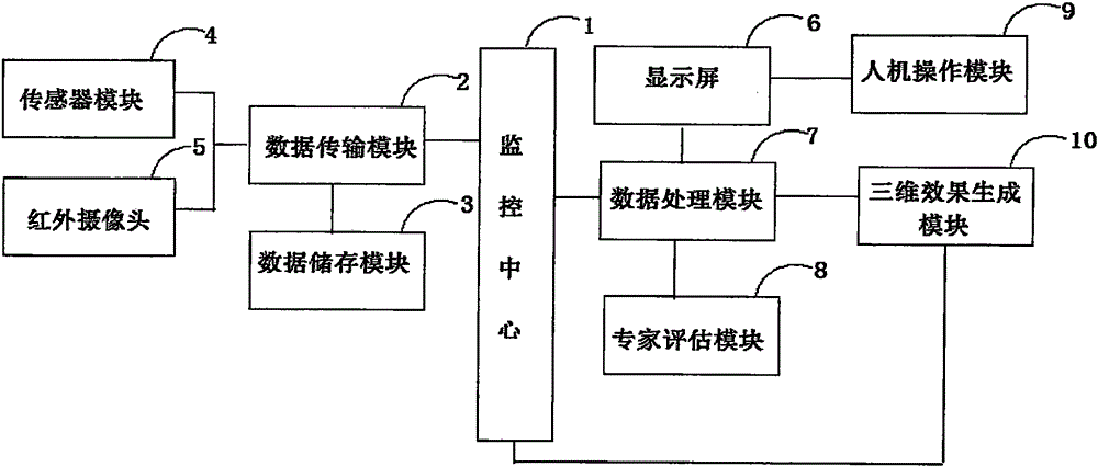
[0034] Such as figure 1 As shown, the embodiment of the present invention provides a geological disaster prediction system, including

[0035] The sensor module 4 is used for real-time acquisition of geological environment data;

[0036] Infrared camera 5 is used to collect video data of the geological environment in real time;

[0037] The data transmission module 2 is used to transmit the obtained geological environment data and video data to the data storage module 3 for storage through the network, send them to the monitoring module for data processing, and send them to the expert assessment module for risk assessment and early warning;

...


PUM


Abstract

The invention discloses a geological disaster predication system which comprises a sensor module, an infrared camera, a data transmission module, a monitoring center, a data processing module, an expert assessment module, a 3D effect generation module, a display screen and a man-machine operation module. The system can accurately predict the time and geological range of a geological disaster, the geological state can be presented for a worker via the 3D generation module, so that the worker can observe and sense geological change, and the prediction accuracy is further improved.

Description

technical field [0001] The invention relates to the field of geological disaster monitoring, in particular to a geological disaster prediction system. Background technique [0002] Geological disasters refer to phenomena or events that cause sudden or gradual damage to the geological environment due to geological action (natural, man-made or comprehensive), and cause loss of human life and property. In recent years, geological disasters such as mudslides, landslides, and ground subsidence have occurred frequently, which have brought huge losses to people's lives and property. How to deal with various geological disasters, improve the disaster prevention and control of the whole society and reduce disaster losses is an urgent task we are facing. The current geological disaster early warning system integrates a variety of environmental data measurement components, and uses the communication network to transmit the data and images measured by the measurement components from th...

Claims


Application Information

Patent Timeline
IPC IPC(8): G08B21/10
CPCG08B21/10
Inventor 杨斌谊
Owner XI'AN PETROLEUM UNIVERSITY
Why Eureka
Try Eureka