Dual-mode real-time pseudo-range differential positioning system and pseudo-range correction data generation method

A real-time pseudorange difference, positioning system technology, applied in satellite radio beacon positioning systems, radio wave measurement systems, measurement devices and other directions, can solve the problems of low navigation accuracy, unable to achieve accurate vehicle navigation, and achieve a simple system. Effective and easy to implement and promote, and improve the effect of positioning accuracy

Inactive Publication Date: 2015-12-23
GUILIN UNIV OF ELECTRONIC TECH
View PDF2 Cites 23 Cited by
  • Summary
  • Abstract
  • Description
  • Claims
  • Application Information

AI Technical Summary

Problems solved by technology

[0006] In the field of vehicle navigation, because the navigation accuracy of GPS or BDS system is not high, the

Method used


Image

  • Dual-mode real-time pseudo-range differential positioning system and pseudo-range correction data generation method
  • Dual-mode real-time pseudo-range differential positioning system and pseudo-range correction data generation method
  • Dual-mode real-time pseudo-range differential positioning system and pseudo-range correction data generation method

Examples


Embodiment Construction

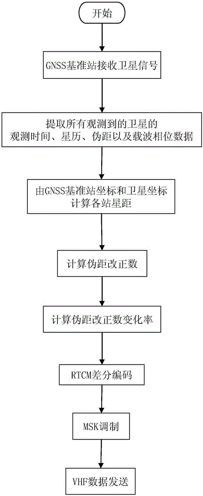
[0031] The present invention will be further elaborated below in conjunction with the embodiments and the accompanying drawings.

[0032] Embodiment of dual-mode real-time pseudorange differential positioning system

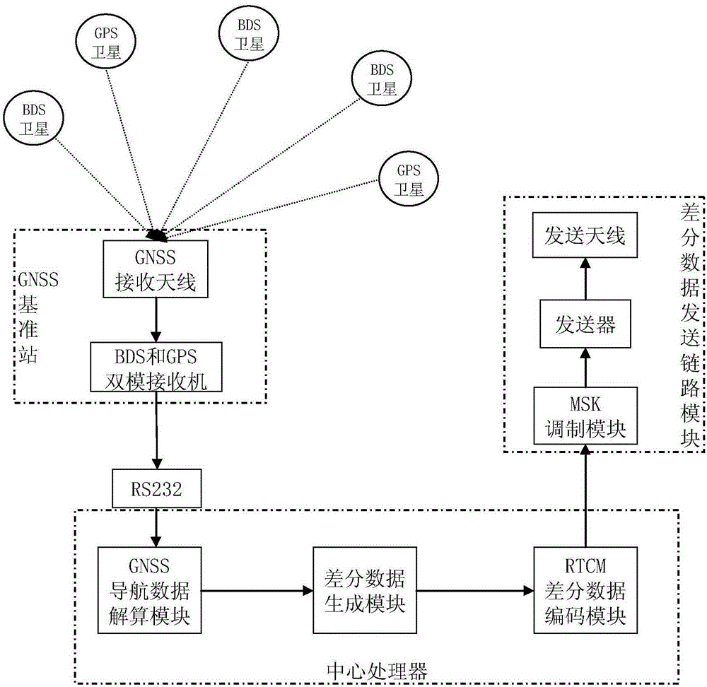
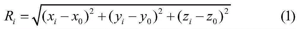
[0033] The structure of this BDS and GPS dual-mode real-time pseudorange differential positioning system embodiment is as follows figure 1 As shown, it includes the central processor and its connected GNSS reference station and differential data transmission link module. In this example, the GNSS reference station includes a BDS and GPS dual-mode receiver and its configured GNSS receiving antenna. The GNSS reference station is fixedly installed at a certain location, and its coordinate position is known accurately. The GNSS reference station receives multiple satellites in real time through the GNSS receiving antenna. Signals from GPS and BDS satellites.

[0034] In this example, the central processor includes a GNSS navigation data calculation module, a differ...


PUM


Abstract

The invention relates to a dual-mode real-time pseudo-range differential positioning system and a pseudo-range correction data generation method. The system comprises a central processor, a GNSS reference station, and a differential data transmitting link module, wherein the GNSS reference station and the differential data transmitting link module are connected with the central processor. The GNSS reference station comprises a BDS, a GPS dual-mode receiver, and a GNSS receiving antenna, wherein the coordinate precision of installation points is known. The central processor comprises a GNSS navigation data resolving module, a differential data generation module, and an RTCM differential data coding module. The differential data transmitting link module comprises an MSK modulation module, a transmitter, and a transmitting antenna, wherein the MSK modulation module, the transmitter and the transmitting antenna are connected sequentially. The method comprises the steps: enabling the GNSS reference station to receive the ephemeris and navigation data, obtained through observation at the same moment, of all GPS and BDS satellites, and transmitting the data to the central processor in real time; extracting data of all satellites; calculating the distances from the station to the satellites; obtaining a pseudo-range correction value and a pseudo-range correction value change rate; and transmitting the data to a peripheral GNSS user after RTCM differential coding and MSK modulation. The system and method greatly improve the real-time navigation positioning precision.

Description

technical field [0001] The invention relates to the technical field of high-precision navigation and positioning, in particular to a dual-mode real-time pseudo-range differential positioning system using BDS and GPS satellites and a method for generating pseudo-range correction data. Background technique [0002] Global Satellite Positioning System (GPS) is a navigation, positioning, timing, and speed measuring system developed by the U.S. military in the early 1970s based on the "meridian satellite navigation and positioning" technology with global, all-round, and all-weather advantages. It has been widely used in people's daily life, especially in the fields of vehicle navigation and precise positioning, and even some military fields have a strong dependence on the GPS system. [0003] my country's second-generation Beidou satellite navigation system (BDS), as one of the most important infrastructures for national space security and economic development, has officially pro...

Claims


Application Information

Patent Timeline
IPC IPC(8): G01S19/42G01S19/41G01S19/33
CPCG01S19/425G01S19/33G01S19/41
Inventor 符杰林蒙聚杰王俊义刘争红杨飞
Owner GUILIN UNIV OF ELECTRONIC TECH
Why Eureka
Try Eureka